![]()
![]()
![]()
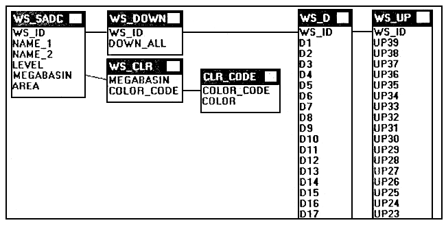
The complete database holds the following fields:
| NAME | TYPE | WIDTH | DESCRIPTION |
| WS_ID | text | 4 | numeric identifier in text format |
| NAME_1 | text | 30 | name of major outflowing river |
| NAME_2 | text | 100 | name of secondary river(s) |
| LEVEL | integer | 3 | level (distance from final sink in number of basins) |
| MEGABASIN | text | 30 | name of megabasin |
| AREA | real | 15 | surface area in km2 |
| COLOR_CODE | integer | 1 | colour coding (numerical) |
| COLOR | text | 9 | colour |
| DOWN_ALL | text | 180 | combined string of all downstream basin ID's |
| D1…D39 | text | 4 | downstream basin ID's |
| UP0..UP39 | text | 4 | upstream basin ID's |
Figure 1: Linking of the separate database files is done as follows:
An installation file (install bat) file has been provided on disk for automatic installation on the C: drive only. Files will then be expanded to the C:\ALCOMWRD\WS\ directory with specific subdirectories for each type of file. The \DBASE, \DOC and \MAP subdirectories respectively hold database files (extension DBF and APR), document files (DOC and TXT) and mapping files (BNA, GSM, PRJ, CUR, BAS and BAT). The complete interface will be available only for users who have Lotus approach by opening the WS_SADC.APR file but a similar interface in other database packages can be developed rather easily following the instructions in this document on the interface.
![]()
![]()
![]()