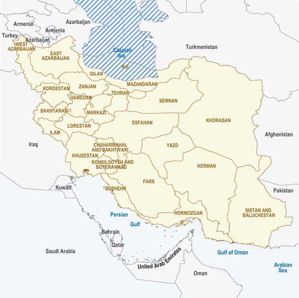
With an area of more than 1.6 million square km Iran is the sixteenth largest country in the world. The country is situated in the eastern part of the northern hemisphere, in southwest Asia (Figure 1).
The elevation ranges from below sea level to more than 5 000 metres above sea level. The temperature varies between minus 30°C and plus 50°C. Annual precipitation varies from about 25 mm in the Central Plateau to over 2 000 mm in the Caspian Coastal Plain, with a national annual average of 250 mm. Central Iran is a steppe-like plateau with a hostile climate, surrounded by desert and mountains (Zagros on the western border and Alborz to the north). Approximately 90 percent of the country is arid and semi-arid.
FIGURE 1
Map of Iran

Underground water irrigates the oases where a wide variety of grains and fruit trees are cultivated. The shores of the Caspian Sea have a humid climate and are suited to tropical and subtropical crops (citrus, cotton, rice and tea). The annual evaporation loss is high, ranging from about 700 mm along the Caspian Sea shores to over 4 000 mm in the Central Plateau and southern part of the Khuzestan and Southern Coastal Plains in the southwest, more than 16 times the annual average rainfall (Moameni, 2000).
In 2002, the population of Iran amounted to 68 million people, the rural population being about 23 million. The food sector accounts for about 40 percent of Iran's gross national product (GNP) and 40 percent of the "added value" in the national economy. The farming subsector contributes 57 percent of the added value of the food sector. Food security has a high priority in the country.
According to FAO statistics, in 2001 the cultivated area amounted to 16.5 million ha, of which 14.3 million ha were planted to arable crops and fallow and 2.3 million ha to permanent crops. The irrigated area in 2001 amounted to 7.5 million ha. Agricultural land availability is not a major constraint in the development of Iranian agriculture. The major constraint is the availability of water.
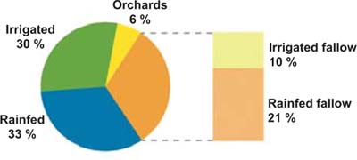
About 90 percent of the irrigated land is under annual crops (including fallow), the remaining 10 percent being used for the production of perennial crops (mostly orchards). In rainfed areas, annual crops constitute about 98 percent of the total production (Moameni, 2000). During dry years, about 8 to 12 percent of the total production comes from dry land areas. However, in wet years this figure can rise to 35 percent. Figure 2 shows the land use distribution.
In many regions of the world, the increasing demand for food in the coming decades cannot be met by extending the area of land under cultivation but only by increasing the intensity of their agriculture. A more efficient use of the land as a result of intensification requires less forest to be cleared for farming purposes and preserves a greater genetic diversity of plant species. In Iran the cultivable land area could in principle be increased but an intensification of crop production is needed to compensate in particular for water scarcity.
FIGURE 2
Distribution of major categories of
agricultural land use

It is unlikely that the required level of crop production could be obtained simply by increasing the irrigated area. An intensification of production is necessary. This involves several factors, such as land consolidation, leveling, improved irrigation methods, balanced fertilization, improved seeds, disease and pest control and mechanization. Balanced fertilization is an essential factor for achieving yield and quality improvements (Malakouti et al., 2004).