![]()
![]()
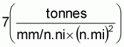
Table 1. Areas of recordings (in thousand square nautical mile), average integrator deflection in mm/nautical mile (INT) and indices of abundance (IND) in each sub-area.
|
SUB AREA
|
AREA OF REC
|
SMALL PEL FISH |
DEM FISH |
AREA OF REC
|
MESOPEL FISH |
"0-GR" FISH/PLANKTON |
||||||||||||
|
SPRING |
AUTUMN |
SPRING |
AUTUMN |
SPRING |
AUTUMN |
SPRING |
AUTUMN |
|||||||||||
|
INT |
IND |
INT |
IND |
INT |
IND |
INT |
IND |
INT |
IND |
INT |
IND |
INT |
IND |
INT |
IND |
|||
|
1 |
3.0 |
9.4 |
28 |
3.1 |
9 |
2.7 |
8 |
2.9 |
9 |
22.0 |
123.0 |
2700 |
29.1 |
640 |
46.4 |
1000 |
96.8 |
2100 |
|
2 |
3.4 |
2.4 |
8 |
2.4 |
8 |
4.1 |
14 |
20.1 |
68 |
40.0 |
106.0 |
4200 |
42.9 |
1700 |
39.2 |
1600 |
45.6 |
1800 |
|
3 |
5.0 |
5.5 |
28 |
5.1 |
26 |
3.8 |
19 |
1.3 |
7 |
43.0 |
93.5 |
4000 |
54.0 |
2300 |
64.0 |
2800 |
61.2 |
2600 |
|
4 |
2.1 |
5.8 |
12 |
1.3 |
3 |
1.4 |
3 |
1.5 |
3 |
40.0 |
265.1 |
17800 |
120.8 |
8100 |
77.1 |
3100 |
62.6 |
2500 |
|
5 |
2.1 |
6.5 |
14 |
3.3 |
7 |
1.9 |
4 |
1.0 |
2 |
27.0 |
69.9 |
1900 |
42.3 |
1100 |
||||
|
6 |
5.6 |
6.3 |
35 |
9.7 |
54 |
3.9 |
22 |
1.5 |
8 |
68.0 |
83.7 |
5700 |
68.9 |
4700 |
27.5 |
1900 |
39.4 |
2700 |
|
7 |
6.6 |
1.1 |
7 |
13.2 |
87 |
2.7 |
18 |
1.6 |
11 |
90.0 |
106.5 |
9600 |
121.2 |
10900 |
38.6 |
3500 |
61.2 |
5500 |
|
8 |
2.3 |
1.2 |
3 |
2.1 |
5 |
2.5 |
6 |
1.9 |
4 |
44.0 |
383.7 |
16900 |
92.2 |
4100 |
41.5 |
1800 |
30.3 |
1300 |
|
9 |
1.4 |
1.9 |
3 |
1.3 |
2 |
2.6 |
4 |
0.5 |
1 |
43.0 |
146.4 |
6300 |
45.3 |
1900 |
23.1 |
1000 |
8.4 |
400 |
|
10 |
8.4 |
8.1 |
68 |
1.8 |
15 |
10.0 |
84 |
2.2 |
18 |
18.0 |
67.6 |
1200 |
5.3 |
200 |
31.2 |
600 |
7.2 |
100 |
|
SUM INDEX |
|
206 |
|
216 |
|
182 |
|
131 |
|
|
68400 |
|
35400 |
|
19200 |
|
20100 |
|
 .
.
|
SUB-AREA |
SMALL PELAGIC FISH |
DEMERSAL FISH |
|||||||
|
SPRING |
AUTUMN |
SPRING |
AUTUMN |
||||||
|
1. |
Somali coast 2°-5°N |
196 |
Porcupine fish |
63 |
Herring |
56 |
Snappers, Groupers |
63 |
Various |
|
2. |
Somali coast 5°-10°N |
56 |
Porcupine fish, mackerel |
56 |
Various |
98 |
Groupers |
476x |
|
|
3. |
North-east Somali coast |
200 |
Sardinella |
182 |
Sardinella scad |
133 |
Scavengers, sharks |
49 |
Scavengers |
|
4. |
North Somali coast |
84xx |
Various |
21 |
Horse mack. (o-gr.) |
21 |
Groupers |
21 |
Ponyfish |
|
5. |
West Yemen coast |
98 |
Sardinella, scad |
49 |
Shad, scad |
28 |
Various |
14 |
Various |
|
6. |
East Yemen coast |
245 |
Sardinella, Horse mackerel |
378 |
Sardinella, Horse mack. |
154 |
Ponyfish, shark |
56 |
Catfish |
|
7. |
South-east Oman coast |
49 |
Sardinella, Anchovy |
609 |
Sardinella |
126 |
Ponyfish |
77 |
Threadfin bream |
|
8. |
Gulf of Oman |
21 |
Horse mackerel |
35 |
Scad |
42 |
Threadfin bream |
28 |
Threadfin bream |
|
9. |
West Pakistan coast |
21 |
Various |
14 |
Anchovy, scad |
28 |
Catfish, Croaker |
7 |
Catfish, Croaker |
|
10. |
South Pakistan coast |
476 |
Anchovy, sardine |
105 |
|
588 |
|
126 |
|
|
TOTAL WEIGHT |
1446 |
|
1512 |
|
1274 |
|
917 |
|
|
x Not identified due to bad weatherTable 3. Maximum catch rates (tonnes/hour trawling) and dominant species of pelagic and demersal fish.
xx Including a large portion of mesopelagic fish
|
|
SPRING |
AUTUMN |
|||||||
|
Pelagic trawl |
Bottom trawl |
Pelagic trawl |
Bottom trawl |
||||||
|
1. |
Somali coast 2°-5°N |
0.4 |
Porcupine |
0.3 |
Snapper |
- |
|
- |
|
|
2. |
Somali coast 5°-10°N |
0.5 |
Porcupine |
1.3 |
Mackerel |
- |
|
0.8 |
Scavenger |
|
3. |
North-east Somali coast |
5.4 |
Porcupine |
0.4 |
Boarfish |
0.5 |
Sardinella |
1.0 |
Scad |
|
4. |
North Somali coast |
- |
|
0.8 |
Lizard fish |
- |
|
2.2 |
Golden toothless trevally |
|
5. |
West Yemen coast |
0.1 |
Scad |
- |
|
0.6 |
Shad |
0.5 |
Lizard fish |
|
6. |
East Yemen coast |
0.6 |
Horse mackerel |
6.6 |
Horse mackerel |
2.9 |
Catfish |
4.6 |
Palinurichthys sp. |
|
7. |
South-east Oman coast |
- |
|
1.9 |
Ponyfish |
8.0 |
Threadfin bream |
8.0 |
Threadfin bream |
|
8. |
Gulf of Oman |
- |
|
0.7 |
Scavenger |
- |
|
0.8 |
Crevalle |
|
9. |
West Pakistan coast |
- |
|
1.2 |
Croaker |
- |
|
- |
|
|
10. |
South Pakistan coast |
0.5 |
Anchovy |
1.9 |
Malabar cavalla |
1.5 |
Scad |
7.0 |
Anchovy, catfish |
|
SUB-AREA |
SPRING |
AUTUMN |
|||
|
1. |
Somali coast 2°-5°N |
- |
|
- |
|
|
2. |
Somali coast 5°-10°N |
0.1 |
Lantern fish |
- |
|
|
3. |
North-east Somali coast |
0.5 |
Lantern fish |
- |
|
|
4. |
North Somali coast |
4.5 |
Cardinal fish |
0.8 |
Cardinal fish |
|
5. |
West Yemen coast |
0.1 |
Lantern fish |
9.8 |
Lantern fish |
|
6. |
East Yemen coast |
1.5 |
Cardinal fish |
- |
|
|
7. |
South-east Oman coast |
0.2 |
Lantern fish |
3.0 |
Lantern fish |
|
8. |
Gulf of Oman |
0.2 |
Lantern fish |
1.2 |
Lantern fish |
|
9. |
West Pakistan coast |
- |
|
- |
|
|
10. |
South Pakistan coast |
- |
|
0.1 |
Lantern fish |
Fig. 1. The survey area. Sub-areas are indicated.
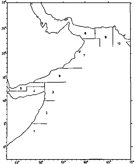
Fig. 2. The distribution of small pelagic fish. 1) Very scattered, 2) scattered, 3) dense. The survey area is indicated. (A)
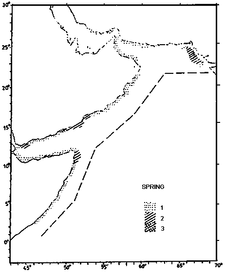
Fig. 2. The distribution of small pelagic fish. 1) Very scattered, 2) scattered, 3) dense. The survey area is indicated. (B)
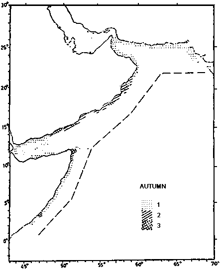
Fig. 3. The distribution of mesopelagic fish. 1) Very scattered, 2) scattered, 3) dense. (A)
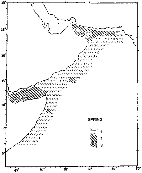
Fig. 3. The distribution of mesopelagic fish. 1) Very scattered, 2) scattered, 3) dense. (B)
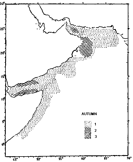
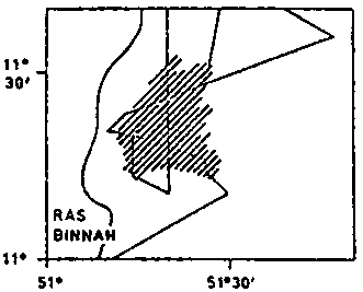
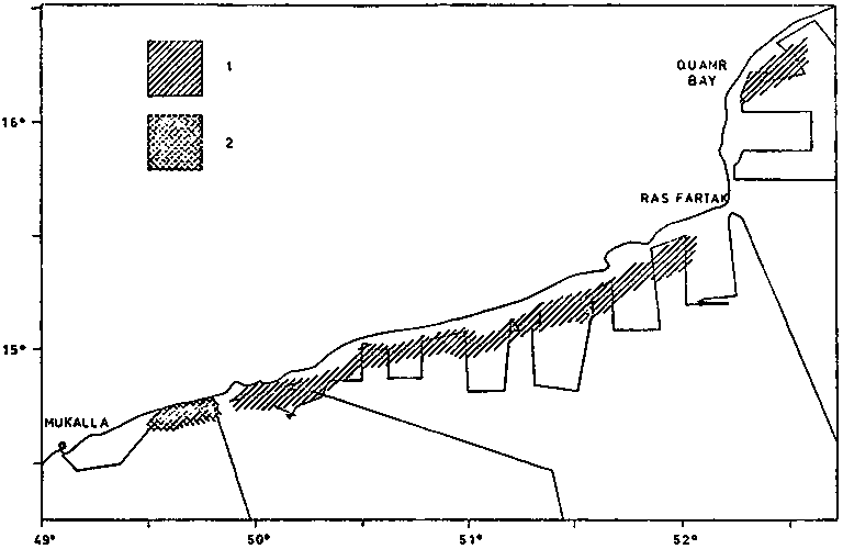
Fig. 4 The distribution of small pelagic fish in spring.
A) North-east Somali coast
B) west coast of Peoples Democratic Republic of Yemen.
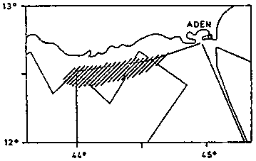
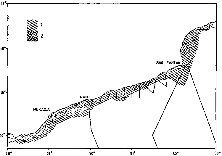
Fig. 5. The distribution of small pelagic fish in autumn at the north-east Somali coast. A) 20 August - 2 September, B) 2 - 5 October.
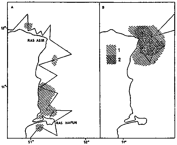
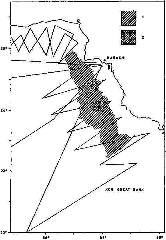
Fig. 9. The distribution of small pelagic fish off the south coast of Pakistan in spring. 1) Scattered, 2) dense.
![]()
![]()