![]()
![]()
![]()
1. Introduction
2. Narrative
3. Ship to ship intercalibration
4. Simultaneous comparative surveys
ANNEX I
ANNEX II
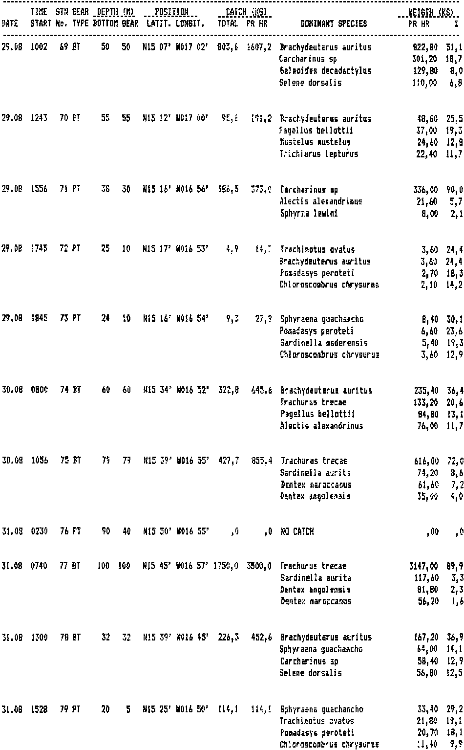
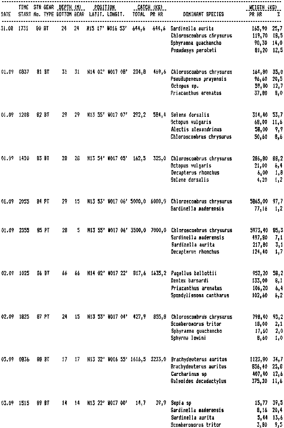
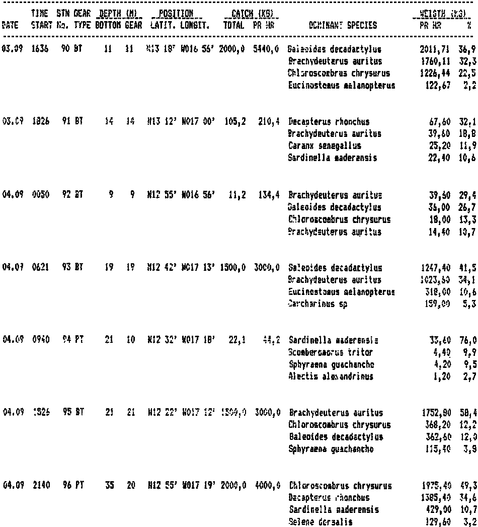
ANNEX III. Abbreviated records of fishing stations
ANNEX IV. Pooled frequency distributions of length of common species
The task during this period of the cruise was to take part In an intercalibration programme with the three vessels CORNIDE DE SAAVEDRA, LOUIS SAUGER AND NDIAGO. The detailed plan for the programme was prepared at a meeting in Dakar on August 28 where the following participated:
Ms. J. Lopez, Jean Jaques Levenez, B. Samb, Senegal;The programme was to include two stages of intercalibration: ship to ship intercalibration for which it was proposed that back scattering from the bottom could be used as reference target if suitable layers of fish was not available, and secondly the simultaneous conduct of surveys of defined areas offish aggregations (mini-surveys.).
E. Josse, Ibrahima Ba, Mauritania:
P. Oliver, J. Miguel, Spain;
Ansa Emmim and fishery biologist, CECAF Secretariat.
Since only 1.5 days was available for CORNIDE DE SAAVEDRA one agreed to start working north of Dakar to save time for her return trip to St. Cruz. All four vessels would participate in the north. LOUIS SAUGER and DR FRIDTJOF NANSEN would continue a simultaneous survey in the south in an area with fish aggregations already identified by the Senegal vessel.
Participants on board the DR FRIDTJOF NANSEN during this part were: B. Samb, Senegal; J. Ndene, Gambia; A.P.J. Da Silva Guinea-Bissau. The vessels own scientific staff were:
G. Sætersdal, A. Abella, O. Alvheim, T. Haugland and E. Molvær.
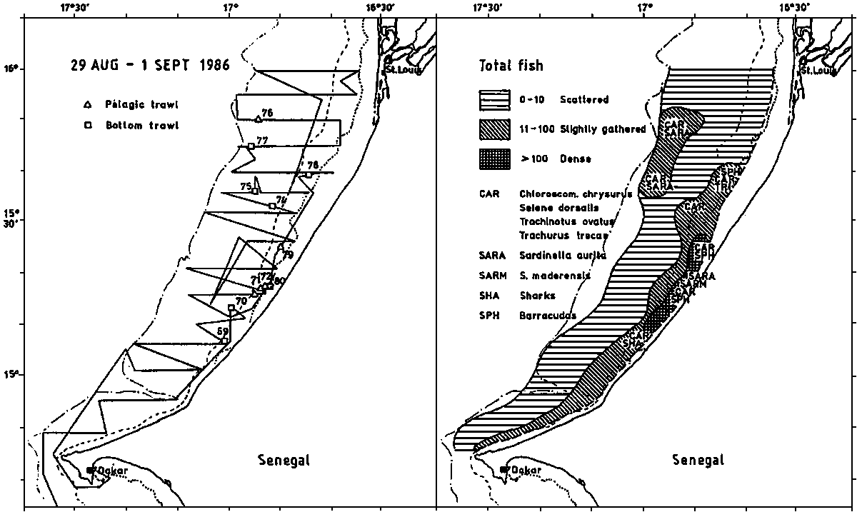
The vessel left Dakar on August 29 at 0100 hrs and Joined CORNIDE DE SAAVEDRA off Cayar at 06 hrs. The two vessels conducted a simultaneous survey of the shelf up to 16° 35 N with an intercalibration exercise at abt. 16° 20 using the sea bottom as reference target. LOUIS SAUGER and NDIAGO then joined and a second intercalibration on bottom back scattering was performed August 30 at abt. 16° 40 between all four vessels. CORNIDE DE SAAVEDRA left for St Cruz and the three remaining vessels surveyed the shelf up to St. Louis.
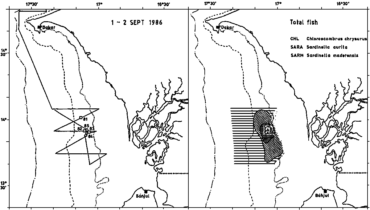
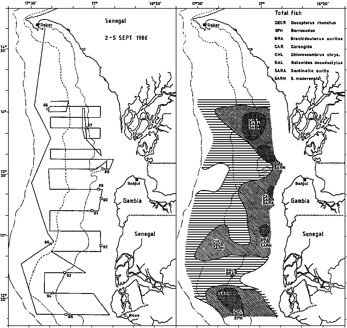
On September 1st. DR FRIDTJOF NANSEN made a preliminary coverage of the indicated school area south of Dakar. Good aggregations were confirmed and on September 2 - 3 the area between 14° 02.5 N and 13° 32.5 N was covered in a joint survey with LOUIS SAUGER. An intercalibration between the two vessels was made with fish layers as reference target from 22 hrs September 2nd to 02 hrs September 3rd. A survey with 10 nm transects of the shelf between l3° 30 N and Cape Roxo was made with DR FRIDTJOF NANSEN on 3-5 Aug.
The organization of the intercalibration based on bottom back scattering was successfully accomplished. The observations from all vessels are recorded in Annex I.
An intercalibration based on suitable fish targets is even especially when different sound frequencies are being used. The LOUIS SAUGER - DR FRIDTJOF NANSEN trial was made in an area with fish layers and schools of varying density. Also plankton of varying density was present and recorded especially by the 38 kHz system. Annex II presents the observations from DR FRIDTJOF NANSEN during the three runs made.
It is expected that when elaborated these data will provide important information on the comparability of the survey results of the vessels.
4.1. Area Cayar - St Louis
4.2. Area south of Dakar; coverage 1st September, Dr F N only
4.3. Area south of Dakar; coverage 2-3 September (Dr FN and LS) and Gambia to Cape Roxo 3-5 September (Dr FN only)
4.4. Biomass estimates
Figure 1 shows the survey tracks and fishing stations worked by DR FRIDTJOF NANSEN in this area, and the main features of the fish distribution found. An aggregation of schools was located inshore between 15° 10 and 15° 30. Catches included sardinellas, various carangids, barracudas and sharks.
Estimates of acoustic abundance in units 1/10 x m2 per nm2 are as follows: (Number of observations represents mean over 5 nm).
|
Range |
N obs. |
Mean |
Area |
Abundance |
|
0-10 |
51 |
3.2 |
795.9 |
2 547 |
|
11-100 |
33 |
14.3 |
336.1 |
4 806 |
|
> 100 |
10 |
79.4 |
50.6 |
4 018 |
|
|
|
|
total |
11 371 |
Shelf between 15° 00 and 15° 35: 7 193Estimates of abundance by types of fish based on identification through fishing gives the following distribution:
Shelf between 15° 00 and 16° 00: 9 831
|
Pelagic type I: |
3 246 |
|
Pelagic type II: |
7 373 |
|
Demersal: |
937 |
|
Total: |
11 556 |
Figure 2 shows the survey tracks and fish distribution for this coverage. The area surveyed was limited by 14° 05 N, abt. 17° 20W, 13° 40 N and abt 10 fathoms towards the shore. A dense school aggregation was found in the eastern parts of the area with Chloroscombrus and other carangids and sardinellas.
Acoustic abundance estimates of all fish based on this survey are as follows: (units as above)
|
Range |
N obs. |
Mean |
area |
Abundance |
|
1-10 |
17 |
4.9 |
337.5 |
1 654 |
|
11-100 |
8 |
35.6 |
140.6 |
5 005 |
|
> 100 |
6 |
335.7 |
43.6 |
14 637 |
|
|
|
|
Total |
21 296 |
Figure 3 shows survey tracks and fish distribution for this survey. The northern part covers the area surveyed the previous day but covers an additional inshore part to abt. 10 m depth. For comparison an estimate was made of the acoustic abundance covering only the area being covered a second time;
|
Range |
N obs |
Mean |
Area |
Abundance |
|
1-10 |
11 |
3.9 |
218.0 |
850 |
|
11-100 |
7 |
14.7 |
185.6 |
2 728 |
|
> 100 |
5 |
196.4 |
95.6 |
18 776 |
|
|
|
|
Total |
22 354 |
The simultaneous survey by LOUIS SAUGER and DR FRIDTJOF NANSEN covered an area limited by 14° 02.5 LN, 17° 20 LW, l3° 32.5 and abt 10 m of depth towards the shore. The estimates of acoustic abundance for all fish within this area were for DR FRIDTJOF NANSEN as follows:
|
Range |
N obs |
Mean |
Area |
Abundance |
|
1-10 |
19 |
6.8 |
365.6 |
2 486 |
|
11-100 |
13 |
29.0 |
260.2 |
7 545 |
|
> 100 |
8 |
354.8 |
140.6 |
49 885 |
|
|
|
|
Total |
59 916 |
An estimate of the acoustic abundance between 13° 32.5 and Cape Roxo is as follows:
|
Range |
N obs |
Mean |
Area |
Abundance |
|
1-10 |
33 |
2.3 |
1 258.6 |
2 895 |
|
11-100 |
29 |
39.5 |
942.2 |
37 217 |
|
> 100 |
6 |
129.3 |
140.6 |
18 180 |
|
|
|
|
Total |
58 292 |
The indices of abundance referred above were transferred into estimates of total biomass. These are as follows: (tons)
|
North of Dakar: |
|
|
LN 15° 00' - 15° 35' |
27 500 |
|
LN 15° 00' - 16° 00' |
40 000 |
|
South of Dakar: |
|
|
LN 13° 32' - 14° 05' |
228 000 |
|
LN 12° 21' - 13° 32' |
178 000 |
|
Total 12° 21' - 14° 05' |
406 000 |
Figure 1. Survey tracks and fish distribution north of Dakar.
Figure 2. Survey tracks and fish distribution first coverage South of Dakar.
Figure 3. Survey tracks and fish distribution 14° 02.5 N to Cape Roxo.
DR FRIDTJOF NANSEN 31/8/86
CECAF COOPERATIVE SURVEY 1986
Record of observations during ship-to-ship intercalibration off northern Senegal with integration of bottom back scattering.
1. Instrument settings:
CORN IDE DE SAAVEDRA: EK 400, 38 KHz, attenuation 30 dB, QD gain - 30 dB, SL + VR = 129,8 dB.2. First trial, C d S and F N. Abt 15° 20, 17° 00, 90 m depth channel 85-95 m., 30/8, 0130 hrs.NDIAGO: EK 400, 38 KHz, att. 30 dB, QD gain - 49 dB, SL + VR = 130 dB.
DR FRIDTJOF NANSEN: EK 400, 38 KHz, att. 30 dB, QD gain - 14.1 dB, SL + VR = 136,6.
LOUIS SAUGER: Biosonics, 120 KHz, transmitter - 13 dB, receiver - 18 dB, pulse length 0,6 ms, treshold 120 mv, band width 2 KHz, 0 dB, 0.224, SL + VR = 81.3 dB
Recorded in order from last mile completed:3. Four vessel trial: Abt 15° 45, 40 m depth, channel 30-50 m, 30/8 1500 hrs.C d S: 1145, 1107, 1520, 1337, 1244, 1051, 931, 1064, 1092, 1056, 1073, 1054, 989 ,889 ,792.
Dr F N: 67, 71, 89, 90, 75, 63, 58, 62, 69, 64, 58, 57, 52.
Recorded in order from last mile completed:L.S. (x 1/100) 10.027, 10.014, 9.495, 9.121, 9.234, 9.213, 8.551, 8.774, 8.793, 8.138, 7.819, 7.971, 8.043.
C d S: 793, 772, 840, 725, 762, 793, 675, 635, 637, 603, 631, 590, 578, 659, 617, 644, 571.
NDIAGO: 52380, 55040, 60440, 54600, 54720, 49140, 46830, 46210. 42270, 42730, 41750, 42190, 43162, 41786.
Dr FN: 50.0, 51.5, 60.2, 52.7, 53.6, 47.5, 45.2, 43.3, 40.8, 41.7, 42.2, 42.7. 44.2, 41.5, 41.6.
DR FRIDTJOF NANSEN 3/9/86.
CECAF COOPERATIVE SURVEY 1986
Record of observations from DR FRIDTJOF NANSEN during ship to ship calibration with LOUIS SAUGER on fish layers 2nd - 3rd August 1986.
Instruments: EK 400 38 kHz, QD integrator: auxiliary instruments EK 400 120 kHz, QM integrators, ES 400 38 (split beam sounder) with color printer.
Integration over whole depth column with write-out each nautical mile. Units: 1/10 x m2/nm2.
Total values allocated on fish/plankton in accordance with information from ES 400 120 kHz - QM system with threshhold and TS observations from ES 400.
|
1st run |
2nd run |
3rd run |
||||||
|
log |
fish |
plkt |
log |
fish |
plkt |
log |
fish |
plkt |
|
618 |
25 |
222 |
631 |
25 |
129 |
646 |
31 |
35 |
|
619 |
6 |
241 |
632 |
6 |
143 |
647 |
0 |
57 |
|
620 |
6 |
230 |
633 |
6 |
129 |
648 |
0 |
67 |
|
621 |
6 |
226 |
634 |
13 |
94 |
649 |
63 |
58 |
|
622 |
6 |
222 |
635 |
38 |
50 |
650 |
69 |
21 |
|
623 |
6 |
143 |
636 |
92 |
31 |
651 |
49 |
0 |
|
624 |
31 |
80 |
637 |
101 |
11 |
652 |
97 |
0 |
|
625 |
302 |
69 |
638 |
16 |
18 |
653 |
314 |
0 |
|
626 |
2601 |
34 |
639 |
13 |
28 |
654 |
843 |
0 |
|
627 |
25 |
48 |
640 |
35 |
31 |
655 |
314 |
0 |
|
628 |
6 |
73 |
641 |
28 |
31 |
656 |
238 |
0 |
|
629 |
6 |
106 |
642 |
50 |
34 |
|
|
|
|
|
|
|
643 |
50 |
72 |
|
|
|
|
|
|
|
644 |
19 |
94 |
|
|
|
|
|
|
|
645 |
44 |
68 |
|
|
|
Alectis alexandrinus (pooled data)

MEAN LENGTH = 38,7 cm N = 34
Modes:, 49 cm, 23 cm, 31 cm, 34 cm, 36 cm, 46 cm
NUMBER OF SUBSAMPLES: 10
SAMPLES FROM ST. NO.: 69 UNTIL ST. NO.: 96
LOWEST STATION: 1
HIGHEST STATION: 431
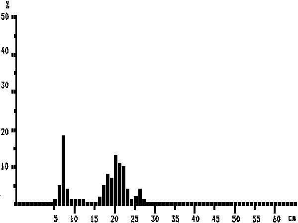
Chloroscombrus chrysurus (pooled data)
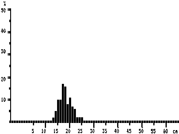
MEAN LENGTH = 18,3 cm N = 1336
Modes:, 17 cm, 20 cm
NUMBER OF SUBSAMPLES: 20
SAMPLES FROM ST. NO.: 69 UNTIL ST. NO.: 96
LOWEST STATION: 1
HIGHEST STATION: 431
Selene dorsalis (pooled data)
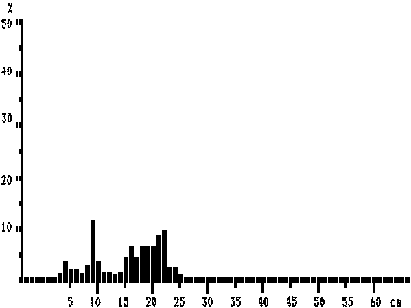
MEAN LENGTH = 15,5 cm N = 429
Modes:, 6 cm, 9 cm, 16 cm, 22 cm
NUMBER OF SUBSAMPLES: 18
SAMPLES FROM ST. NO.: 69 UNTIL ST. NO.: 96
LOWEST STATION: 1
HIGHEST STATION: 431
Trachinotus ovatus (pooled data)
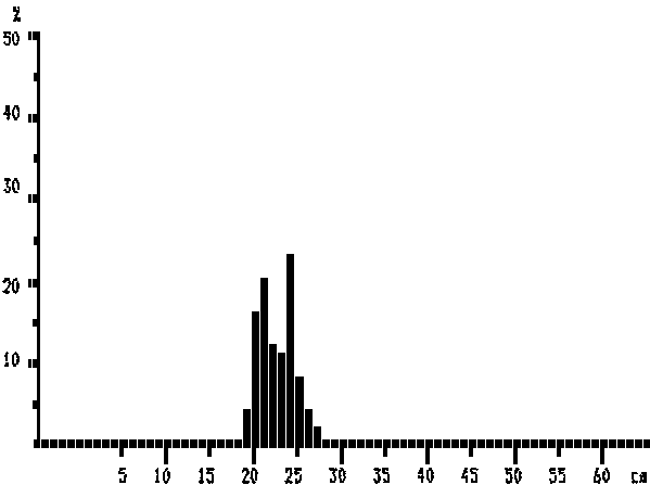
MEAN LENGTH = 22,4 cm N = 93
Modes:, 21 cm, 24 cm
NUMBER OF SUBSAMPLES: 4
SAMPLES FROM ST. NO.: 69 UNTIL ST. NO.: 96
LOWEST STATION: 1
HIGHEST STATION: 431
Trachurus trecae (pooled data)
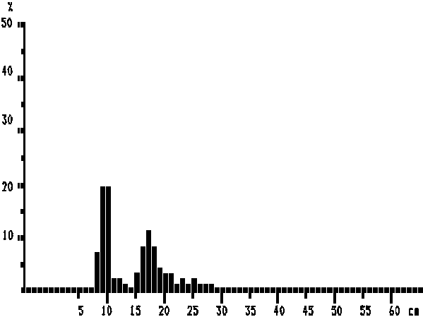
MEAN LENGTH = 14,2 cm N = 465
Modes:, 10 cm, 17 cm, 23 cm, 25 cm
NUMBER OF SUBSAMPLES: 4
SAMPLES FROM ST. NO.: 69 UNTIL ST. NO.: 96
LOWEST STATION: 1
HIGHEST STATION: 431
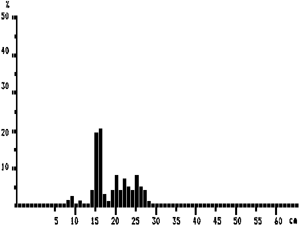
Decapterus rhonchus (pooled data)
MEAN LENGTH = 19,2 cm N = 357
Modes:, 37 cm, 20 cm, 24 cm, 27 cm, 32 cm, 34 cm
NUMBER OF SUBSAMPLES: 14
SAMPLES FROM ST. NO.: 69 UNTIL ST. NO.: 96
LOWEST STATION: 1
HIGHEST STATION: 431
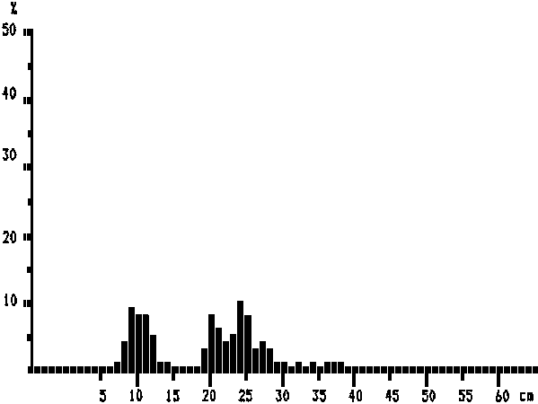
Sardinella aurita (pooled data)
MEAN LENGTH = 19,0 cm N = 356
Modes:, 9 cm, 11 cm, 16 cm, 20 cm, 22 cm, 25 cm
NUMBER OF SUBSAMPLES: 14
SAMPLES FROM ST. NO.: 69 UNTIL ST. NO.: 96
LOWEST STATION: 1
HIGHEST STATION: 431
Sardinella maderensis (pooled data)
MEAN LENGTH = 16,4 cm N = 679
Modes:, 7 cm, 18 cm, 20 cm, 26 cm
NUMBER OF SUBSAMPLES: 18
SAMPLES FROM ST. NO.: 69 UNTIL ST. NO.: 96
LOWEST STATION: 1
HIGHEST STATION: 431
Sphyraena guachancho (pooled data)
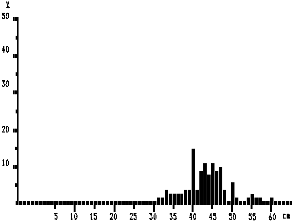
MEAN LENGTH = 43,1 cm N = 133
Modes:, 55 cm, 60 cm, 43 cm, 45 cm, 47 cm, 50 cm
NUMBER OF SUBSAMPLES: 11
SAMPLES FROM ST. NO.: 69 UNTIL ST. NO.: 96
LOWEST STATION: 1
HIGHEST STATION: 431
Sphyraena sphyraena (pooled data)
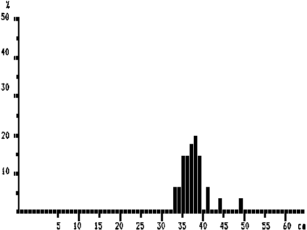
MEAN LENGTH = 37,4 cm N = 36
Modes:, 38 cm, 41 cm, 44 cm, 49 cm
NUMBER OF SUBSAMPLES: 2
SAMPLES FROM ST. NO.: 69 UNTIL ST. NO.: 96
LOWEST STATION: 1
HIGHEST STATION: 431
![]()
![]()
![]()