![]()
![]()
![]()
Jeffrey E. Herrick[1]
Key words: assessment, thresholds, soil and water conservation, soil quality
Pasture degradation is a significant problem throughout the world. Restoration of degraded pastures is expensive. This information is needed in order to (a) target limited resources to degraded areas with the highest potential for recovery, (b) document restoration project success, and (c) explain the effects of restoration projects to farmers and funding organizations. Most existing monitoring systems either focus on one specific aspect (e.g. forage production) or are extremely expensive. Furthermore, they rarely integrate soil and vegetation indicators.
The USDA Agricultural Research Service in cooperation with a large number of individuals and organizations recently developed a flexible system for designing long-term soil and vegetation monitoring programs for grassland, shrubland and savanna ecosystems (Herrick et al., in review). The indicators reflect changes in basic ecological processes which are fundamental to the sustainability and productivity of nearly all pasture and rangeland ecosystems.
Three core soil and vegetation measurements (line-point intercept, gap intercept and soil aggregate stability) are used to calculate multiple indicators of three key ecosystem attributes: soil and site stability, hydrologic function and biotic integrity. The core measurements can also be used to generate use-specific indicators, such as composition of key forage species. Optional measurements are incorporated based on site-specific resource concerns, such as nutrient availability. Nutrient availability is treated separately because different measurements are often required for different soils and plant species. Furthermore, nutrient availability is difficult to measure accurately in the field and biotic integrity indicators generally reflect overall soil nutrient status at a much lower cost. However, where nutrient limitation is a significant problem which can be addressed through management, nutrient measurements should be considered.
The long-term monitoring approach is based on the following five guidelines. (1) Measurements selected should support indicators which are consistently related to changes in soil stability, hydrologic function and biotic integrity in a way that is readily understood by farmers. (2) Measurements should be rapid, simple, inexpensive, and repeatable. (3) Photographs and qualitative indicators can be used to supplement, but not replace, quantitative measurements, particularly when the monitoring will be completed by more than one person. (4) All measurements should be completed in the field, eliminating costs and delays associated with laboratory analyses. (5) Long-term monitoring (described here) must often be supplemented by more frequent management-dependent assessments in order to adjust management to achieve long-term goals. For example, grazing management is often used to achieve an increase in species which are more effective at minimizing soil erosion. The long-term indicators might include grass basal or canopy cover supplemented by erosion bridge measurements at selected sites. A short-term management indicator might be post-grazing stubble height of key grass species, or even the number of days which livestock spend in the pasture.
Monitoring intensity depends on both time and expertise available, and on data quality required. We have defined four levels of monitoring intensity. Level I is based on repeat photographs. It is appropriate for qualitative documentation of large changes in plant community structure and composition and may be supplemented by qualitative observations. Level II is based on semi-quantitative measurements which are equivalent to the Level III methods. Level III includes the three core quantitative measurements. Level IV includes both these core measurements and supplementary measurements selected to address site-specific concerns. Many monitoring programs include two or more monitoring levels. A subset of Level III monitoring sites may be selected for Level IV monitoring, or a larger number of sites may be selected for Level I monitoring in order to document that the general types of changes quantified at the Level III sites are occurring throughout the farm.
A six-step process is used to design and implement the monitoring program: (1) define monitoring objectives (general trend, degradation risk, restoration, and site-specific treatment effects), (2) stratify farm or ranch into homogeneous monitoring units, (3) conduct preliminary evaluations and select monitoring sites, (4) select indicators and define measurement number and frequency, (5) describe monitoring sites, and (6) establish permanent transects (Fig 1) and collect baseline data. Where monitoring objectives are clear and monitoring sites have already been selected (e.g. where monitoring restoration efforts on relatively small plots of land), steps 1-3 and 5 can be omitted.
The most effective monitoring program design team includes both the farmer or land manager, and one or more facilitators who are familiar with monitoring program design, local soil-landscape relationships, management systems and significant causes and consequences of degradation. The facilitator(s) should also be skilled at communicating with farmers and integrating their knowledge into the design. It is critical to involve farmers in all six steps of the design and implementation process and to ensure that they understand the value of repeating the measurements at regular intervals. We have successfully taught the core measurement methods to a broad range of people, including school children as young as 7 years.
The measurements described here are limited to dynamic properties which are expected to change significantly during within duration of the monitoring program. Inherent soil properties, such as soil texture, are included in the “Monitoring Site Description” (Step 5).
Core Measurements
The Level III core measurements are described here. Semi-quantitative Level II measurements are described in the manual (Herrick et al., In Review). Photo points are also included to provide visual documentation.
Line-point intercept
The line-point intercept is used to record vegetation cover. Bare ground is one of the most useful predictors of soil erosion. The line-point intercept is also a rapid and accurate method for monitoring changes in plant community composition. All species intercepted by a thin pin (straight piece of coat-hanger sized wire) dropped through the foliage are recorded at each point along the transect. Identification to the species level is not always necessary. Ground cover classes including plant base, rock, lichen, moss, litter and bare soil are also recorded. Plant height class can be recorded every 5th or 10th measurement using bands of red and white paint marked on the pin.
Gap intercept
The gap intercept method is used to record gaps in the vegetation where wind or water erosion may occur, or where invasive species (weeds) may become established. Gaps intercepted by the line which are longer than a minimum (e.g. 15cm) are recorded. In agroforestry systems, the method can be modified to record tree canopy to generate a rapid indicator of spatial structure.
Soil stability in water
Soil stability in water is an excellent indicator of soil quality, soil erosion resistance and, in many cases, water infiltration capacity. Larger aggregates (> 250 micron) are stabilized by recently generated organic matter, such as fungal hyphae and root exudates. Eighteen aggregate stability measurements can be completed in less than 10 using a simple kit (Herrick et al., 2001).
Supplementary measurements
Optional supplementary measurements will be detailed in the full text version (Table 1).
The core methods have been evaluated in nine U.S. states and Mexico. We are continuing calibration and statistical replication studies.
Table 1. Measurements and selected indicators and their relationship to the three key ecosystem attributes. Numerous additional indicators can be calculated from each measurement. Additional supplementary methods for riparian systems are not included.
|
Method |
Indicator (bold italics = core set) |
Soil/Site Stability |
Hydro. Function |
Biotic Integrity |
|
Core Measurements |
|
|
|
|
|
Line-Point Intercept |
Total cover |
X |
X |
X |
|
Total plant canopy cover |
X |
X |
X |
|
|
Total plant basal cover |
X |
X |
X |
|
|
Minimum estimate of species richness |
|
|
X |
|
|
Percent cover of species resistant to catastrophic disturbances, forage species, woody species, etc... |
X |
X |
X |
|
|
Gap Intercept |
Proportion of line covered by canopy gaps > x cm long |
X |
X |
X |
|
Proportion of line covered by basal gaps > x cm long |
X |
X |
X |
|
|
Soil Stability Test |
Average value for each depth |
X |
X |
X |
|
Average for samples from bare soil and under different types of vegetation |
X |
X |
X |
|
|
Proportion of highly stable samples (category 6) |
X |
X |
X |
|
|
Supplementary Measurements |
|
|
|
|
|
Belt Transect/ Point-Quarter |
Density of important, but rare or patchy species poorly detected by line-point intercept |
|
|
X |
|
Species Richness |
Total number of species |
|
|
X |
|
Impact Penetrometer |
Total number of strikes by depth (0-5, 5-10cm, etc...) |
|
X |
|
|
Ratio of number of strikes in surface and subsurface. |
|
X |
|
|
|
Single Ring Infiltrometer |
Time required for 50mm of infiltration |
|
X |
|
|
Erosion Pins |
Change in soil surface height and roughness |
X |
X |
|
Fig 1. Transect layout for
different types of monitoring sites. The spoke design (a) is the most efficient,
perpendicular transects
Fig 1. Transect layout for
different types of monitoring sites. The spoke design (b) are used to across
gradients or transitions, and a combination of perpendicular and parallel
transects
Fig 1. Transect layout for
different types of monitoring sites. The spoke design (c) are used in riparian
systems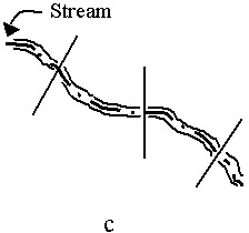
Herrick JE, Van Zee JW, Havstad KM, Whitford WG (In Review) Monitoring Manual for Grassland, Shrubland and Savanna Ecosystems
Herrick JE, Whitford WG, de Soyza AG, Van Zee JW, Havstad KM, Seybold CA, Walton M (2001) Field aggregate stability kit for soil quality and rangeland health evaluations. CATENA 574: xxx - xxx
Andrea Schlönvoigt[2], Muhammad Ibrahim[3]
Key words: desertification, fodder banks, shelter belts, timber
In Central America, the Pacific dry forests originally occupied around 550,000 km2, extending from Mexico to Panama. Today only 2 % of these forests are considered still to be intact. Transformation of these forests into rangelands is responsible for degradation of extensive areas in Central America (Szott et al., 2000). Since the protecting forest cover has been strongly reduced, wind erosion threatens the bare soils during the dry season. These ecoregions provide a potential foci for desertification, even in Central America which is located in the humid intertropical convergence zone (Schlönvoigt 2000). Loss of forest cover also means loss of biodiversity and genetic resources, natural resources such as soil and water, i.e. land productivity and sustainability. Rural poverty in Central America is directly related to these degradation processes, which cause migration into urban centers which often are not able to provide sufficient or adequate employment (Hajek 1995). This review is analysing the potential of silvopastoral systems for intensification of fodder production on dry rangelands in Central America, based on experiences from the region and from other countries which face similar conditions and problems.
Traditionally, dry forest ecosystems like the Matorrales in Mexico, have been used for cattle grazing. On intensifying cattle production, dry forests were replaced by drought tolerant fodder species like Hyparrhenia rufa and Brachiaria brizantha. Management of multipurpose trees and shrubs which provide shelter and fodder is considered a promising option for further increase and conservation of fodder supply, especially during the dry period. These species can be integrated as shelterbelts or fodder banks according to the main objective of the production system and the local conditions.
In natural dry forest ecosystems, the selective management of valuable forest species could provide an option to develop low external input systems for sustainable fodder production under grazing conditions. In order to increase the number of “green” sprouts and to eliminate undesired species, selective shoot pruning of certain forest species contributes to maintain fodder during the dry season and guarantees the persistence of the desired species (Cabral and Treviño 1989). In the Matorral Tamaulipeco in northeastern Mexico, Acacia berlandieri was the most promising species for fodder production in terms of persistence to prunings at different times of the year and biomass production (Reyes and Foroughbakhch 1989). Its fodder production can be estimated by the equation Y = 14.686 + 3.314 * N + 0.883 * N2 (r2 = 0.938), where Y means the total fodder production at the time of harvest in kg dry matter and N means the number of sample units equal to a selected branch which is representative in terms of branch growth and foliage density.
In natural dry forest ecosystems, leguminous species represent the most important plant family for fodder supply during the dry season. Compared to grass species they are less digestible due to high contents of lignin and fibre. Although higher in protein, their energy values are lower than of herbaceous species caused by lower digestibility. Establishment of these species is slow and requires isolation from cattle, which increases the costs for establishment and maintenance. A complementary effect is deferred grazing: availability of fodder during the dry season may relieve grasslands from grazing and allow for rehabilitation. Finally, woody browse species contribute to landscape stability by decreasing the risk of wind and water erosion, as stated already above. The assessment of the value of fodder plants should consider the forrage value to the animal, the economic value to the landholder and the landscape value to the farm or region (Lefroy et al., 1992; Table 1).
Table 1. Assessment of the value of fodder plants (adapted from Lefroy et al 1992)
|
Forage value to the animal |
Economic value to the landholder |
Landscape value to the farm or catchment |
|
Characteristics of plant material: · accessible · acceptable · digestible (>55% DMD)* sufficiently high in energy, proteins, minerals · non-toxic |
Characteristics of plantation: · establishment cost · management cost · time to first use · substitution value · persistence · complementary effects · competitive effects |
Compatibility of plant material, plantation design and site requirements for · reduced wind erosion · reduced water erosion · low competition in water use · increased nutrient cycling · improved soil structure · increased genetic diversity · degreased energy inputs |
|
Measure: Response in grazing animals |
Measure: Return of investment |
Measure: Landscape stability |
Tree planting or natural regeneration of timber trees in pastures faces the limitation that the trees need to be protected from the grazing and moving cattle. Planting the trees in cow dung instead of soil reduced browsing (0.4 vs 6.5 %, respectively) and trampling (17 vs 56 %, respectively) damage of Samanea saman seedlings in intensively grazed pastures due to a repellent effect of the dung (Barrios et al., 1998). A study of natural regeneration of valuable timber species, like Geoffroea decortican, Schinopsis balansae and Prosopis nigra, in the Argentinean Chaco concluded that grazing management is an important tool to lower tree damages due to cattle activities; i.e. a decrease from 65 to 48 % when pasture availability increased from 3 to 5 t dry matter ha-1 (Simón et al., 1998). However, improved and highly productive pastures can be strong competitors for the trees and reduce their growth, as was observed in Caqueta, Colombia, for E. cyclocarpum where mean annual tree height increment was 0.4 m with Brachiaria decumbens pastures, compared to 0.7 m with native pasture species (Cipaguauta et al., 1999), as well as trees which dominate the pastures may reduce pasture biomass production, as was shown for Pinus caribaea associated with Panicum maximum under humid climatic conditions (Gallo et al., 1999; Y = 28.76 - 1.08 x; where Y is pasture dry matter yield in kg ha-1 day-1 and x is tree basal area in m2 ha-1). In contrast, under arid climate conditions in India, seven years after establishment, the association with pasture (Cenchrus ciliaris) increased height growth of Acacia tortilis, but had no significant effect on stem diameter, while pasture production was not reduced (Shankarnarayan et al., 1987).
In Central America, the use of protein fodder banks with leguminous shrubs, which provide supplementary fodder during the dry period, has received increasing attention (Ibrahim et al., 2001). For fodder banks, the shrubs are planted in plots at high densities, generally close to the stable or other feeding places, where they are pruned once or twice per year at the end of the rainy season in order to induce intensive sprouting that provides the fodder during the dry season. Several of these fodder species (e.g. Cratylia argentea, Leucaena leucocephala and Gliricidia sepium) are more productive and have relatively high nutritive value (Table 2) compared to tropical grasses (e.g. Hyparrhenia rufa), which generally provide the major source of fodder for cattle (Ibrahim et al., 1998; Ibrahim et al., 2000a). The problem of toxic ingredients in leguminous species could be resolved in the case of L. leucocephala where cattle was fed successfully only with this species, when a bacteria capable of degrading DHP (3 hydroxy-4-(IH) pyridone, toxic compound from amino acid mimosine) was introduced (Lefroy et al., 1992).
Table 2. Fodder quality of some woody leguminous and non-leguminous perennials adapted to arid - semihumid climate conditions (adapted from Ibrahim et al., 2001).
|
Species |
Plant compartment |
CP1 % |
IVDMD % |
NDF % |
ADF % |
Source |
|
Cratylia argentea |
Edible |
20.0 |
55.2 |
51.0 |
33.9 |
Ibrahim et al., 2000a |
|
Total |
23.8 |
51.8 |
52.0 |
34.4 |
Flores et al., 1998 |
|
|
Total |
NA |
45.3 |
|
|
Valerio, 1990 |
|
|
Guazuma ulmifolia |
Total |
11.8 |
44.6 |
|
|
Herrera, 1990 |
|
Total |
11.0 |
43.8 |
52.0 |
34.4 |
Flores et al., 1998 |
|
|
Gliricidia sepium |
Total |
24.3 |
67.4 |
41.0 |
25.1 |
Mochuitti, 1995 |
|
Total |
23.2 |
64.7 |
43.0 |
|
López, 1995 |
|
|
Total |
27.2 |
54.3 |
53.3 |
32.7 |
Camero, 1991 |
|
|
Leucaena leucocephala |
Leaves |
30.3 |
68.2 |
|
|
Hernández, 1996 |
|
Young stems |
18.5 |
46.9 |
|
|
|
1 CP: crude protein; IVDMD: in vivo dry matter digestibility; NDF: neutral detergent fibre; ADF: acid detergent fibre
Shelter belts are line plantings of single or multiple rows of trees, shrubs, grasses or other adapted species, which in the ideal situation are established perpendicular to the prevailing wind direction or with varying directions as a network. Their principal objective is to reduce excessive wind speed near the soil surface, thus protecting associated pastures, animals and soils. Bird et al., (1992) describe the important positive effects of shelter on plants such as: reduced water loss as a result of reduced wind speed and shading; retention of heat of soil and air in the sheltered areas; reduced inward radiation during the day and decreasing outward radiation at night; reduced erosion of soil nutrients by wind and water runoff due to litter; reduced mechanical damage to plant tissue; increased mineralisation of soil nitrogen (= increased pasture growth); trapped and recycled nutrients, especially in absence of fertilisers (e.g. N-fixation); nutrients trapped as dust on foliage; reduced soil acidification; and reduced deep infiltration of water to groundwater systems (prevention of the rise of saline water tables). Positive effects on animals are related to: indirect effects on animals through effects on pasture production; provision of foliage or fruit which supplement intake from pasture; reduced livestock maintenance requirements due to shelter (esp. cattle); increased fertility with shelter; and increased survival of newborn animals.
On dry rangelands, strong winds can cause soil losses of more than 20 t ha-1 year-1 (Bird et al., 1992) due to overgrazing, extensive droughts and fires. Although sandy soils are most affected by wind erosion, the loss of “dust” is especially critical, as silt and clay contain a large portion of soil nutrients and organic matter. The importance of shelterbelts for sustainable cattle ranching in drylands is difficult to justify to farmers, as they mainly perceive the loss of area which is required by the wind breaks. Therefore, adoption of shelterbelts could be increased, if they provide secondary products like posts, fruits, insecticides, timber or others. The management of shelter belts for secondary products has to avoid contra-productive effects for protection. The exploitation of timber is generally limited, because the strong winds cause stress in the trees which then produce little valuable timber. Therefore, harvesting of shelterbelts might be more adequate for particle boards, chipwood for pulp and paper, wood for energy, posts, rails and poles, which, however, demand extensive planted areas to be economically feasible (Moore, 1992).
The intensive management of leguminous woody species in fodder banks needs further research on their potential adoptability by farmers because these systems are labour intensive and require a new approach of cattle ranching. The introduction of shelter belts in rangelands has been proven for some sites; i.e. that animal production can be sustained on less area. If these systems led to the reduction of areas presently used for cattle ranching, extensive rangelands could be reforested or afforested with adapted forest species for conservation and/or production. These forest plantations could be established as silvopastoral systems or in pure plantations. Grazing of forest plantations might be part of the active fire protection. National incentive programmes supported by the UN-conventions on Global Change, Conservation of Biodiversity and Combat of Desertification should provide a framework which makes the change economically and socially attractive.
Barrios C, Beer J and Ibrahim M (1999) Pastoreo regulado y bostass del Ganado para la protección de plántulas de Pithecellobium saman en potreros. Agroforestería en las Américas 6 (23): 63-68
Cabral I and Treviño B (1989) Efecto de corte en la dinámica de crecimiento de especies de uso múltiple del matorral espinoso Tamaulipeco en el noreste de México. In: Facultad de Ciencias Forestales, Universidad Autónoma de Nuevo León (ed) Simposio agroforestal en México: Sistemas y métodos de uso múltiple del suelo. Memorias Tomo II, León, México, pp 457 - 480
Cipaguauta M, Velasquez J and Gómez E (1999) Estratégias de implementación y experiencias agrosilvopastoriles con pequeños productores en el Piedemonte Amazónico Colombiano. CORPOICA. Memorias Primer Congreso Latinoamericano de Agroforestería para Producción Animal Sostenible, CIPAV, Calí, Columbia. CD-ROM
Bird PR, Bicknell D, Bulman PA, Burke JA, Leys JF, Parker JN, van der Sommen FJ and Voller P (1992) The role of shelter in Australia for protecting soils, plants and livestock. Agroforestry Systems 20: 59-86
Gallo L, Somarriba E, Ibrahim M and Galloway G (1999) Productividad de Panicum maximun bajo Pinus caribaea. Agroforestería en las Américas 6: 57-59 p
Hajek ER (1995) Pobreza y Medio Ambiente. Konrad-Adenauer-Stiftung, CIEDLA, Buenos Aires, Argentina, 579 p
Ibrahim M, Canto G, Camero A (1998) Establishment and management of fodder banks for livestock feeding in Cayo. In: Ibrahim M and Beer J (eds) Agroforestry prototypes for Belize. (Serie Técnica, Manual Técnico 28). CATIE, Turrialba, Costa Rica. pp. 15-43.
Ibrahim M, Franco F, Pezo D, Camero R and Araya J (2000a) Promoting intake of Cratylia argentea as a dry season supplement for cattle grazing Hyparrhenia rufa in the subhumid tropics. Agroforestry Systems (in press)
Ibrahim M, Schlonvoigt A, Camargo JC, Souza M (2001) Multi-strata silvipastoral systems for increasing productivity and conservation of natural resources in Central America. In: Gomide JA, Soares Mattos WR and Carneiro da Silva S (eds) Proceedings of the XIX International Grassland Congress, Piracicaba, Brazil, pp 645 - 649
Lefroy EC, Dann PR, Wildin JH, Wesley-Smith RN and McGowan AA (1992) Trees and shrubs as sources of fodder in Australia. Agroforestry Systems 20:117-139
Moore R (1992) Integrating wood production into Australian farming systems. Agroforestry Systems 20: 167-186
Reyes G and Foroughbakhch R (1989) Comparación de métodos indirectos para evaluar el potencial forrajero en un matorral Tamaulipeco. In: Facultad de Ciencias Forestales, Universidad Autónoma de Nuevo León (ed) Simposio Agroforestal en México: Sistemas y Métodos de Uso Múltiple del Suelo. Memorias Tomo II, León, México, pp 549-557
Schlönvoigt A (2000) Diagnóstico general de los procesos de desertificación en América Central. In: MARN-BID (eds.) Desertificación en América Central: análisis del estado actual y sus implicaciones para el futuro. Sexta Reunión de la UNCCD, El Salvador. Informe Técnico Científico, Tomo 2, pp 3-24 (in press)
Simón M, Ibrahim MA, Finegan B and Pezo D (1998) Efectos del pastoreo bovino sobre la regeneración de tres especies arbóreas comerciales del Chaco Argentino: Un método de protección. Agroforesteria en las Américas 5 (17-18): 84- 87
Shankarnarayan KA, Harsh LN and Kathju S (1987) Agroforestry in the arid zones of India. Agroforestry Systems 5: 69-88
Szott L, Ibrahim M and Beer J (2000) The Hamburger Connection Hangover. Castle Pasture Land Degradation and Alternative Land Use in Central America. CATIE-DANIDA-GTZ, Turrialba, Costa Rica
Margarida M. Carvalho[4], Maurílio J. Alvim[5], Deise F. Xavier[6]
The Atlantic Forest region of Brazil is of major social and economical importance, as it covers about 70% of the population and of the main industrial and agricultural activities of the country (Fundação SOS, 1992).
In the mountainous area of this region, which occurs mainly in the southeastern States, the original dense tropical forest vegetation was mostly cleared, as from the late 18th through the 19th century, for coffee plantations. When the cycle of this crop ended, in the deforested hillsides the spontaneous invasion of molasses-grass (Melinis minutiflora) and of guinea-grass (Panicum maximum) changed the dominant vegetation to naturalized pastures. Today, vast areas of what was once a luxurious tropical forest has become degraded pasture land or abandoned hillsides, prone to soil erosion and further loss of biodiversity.
In Minas Gerais and in some parts of the neighboring States, the low fertility of the main soils (Resende & Resende, 1996), particularly of the red-yellow latosol (oxisol), and the low carrying capacity of the naturalized molasses-grass has led to its substitution for more aggressive and higher yielding species such as Brachiaria decumbens and B. brizantha cv. Marandu (Carvalho & Cruz Filho, 2000).
The Brachiaria species establishment depend on the application of phosphorus fertilizers and on the use of a soil preparation method that is not conducive to soil erosion (Carvalho, 1998). In addition, the long term productivity of the sown grass pastures in these areas depend on the availability of a nitrogen source, among other management factors (Carvalho & Cruz Filho, 2000). In the absence of conditions necessary to the sustainable use of this sown grass pastures, they loose productivity and become degraded within few years.
The silvopastoral systems seem a viable option to develop the degraded pasture land and the abandoned hillsides which predominate in the region, due to its potential for soil fertility improvement and land stabilization, among other advantages to animal production systems.
The soils which predominate in the mountainous areas of the Atlantic Forest are very acid and infertile. Despite this, the naturalized molasses-grass pastures have existed in some parts of the region for many decades, and although producing very low yield, have promoted a reasonable soil cover, except in the sites where the inadequate management, and/or the frequent occurrence of fire have led to its degradation.
Saraiva et al. (1993) observed that the root system of molasses-grass developed mostly in the upper 5 cm of an oxisol, in which nutrient concentration was higher than in deeper layers (Table 1), where root growth was limited by nutrient deficiency. In a glasshouse trial, it was identified that phosphorus deficiency, and to a lesser extent, calcium and magnesium deficiencies, were the main soil factors limiting the possibility of molasses-grass root system to develop in deeper soil profile. However, overgrazing appeared to be the main cause of molasses-grass pastures degradation, as indicated by the results of a grazing experiment (Torres et al., 1982).
Thus, the main causes of the naturalized pastures degradation in this region, overgrazing and deficiency of nutrients in the soils, are among those commonly identified in other ecosystems (Spain & Gualdrón, 1991; Meirelles, 1993).
Table 1. Chemical characteristics of an oxisol, sampled in various depths.
|
Depth (cm) |
pH in water |
O. C.1 (%) |
Al |
Ca |
Mg |
K |
Available P (mg/kg) |
|
Exchangeable, cmolc/kg |
|||||||
|
0 - 2,5 |
4,05 |
2,09 |
1,29 |
0,43 |
0,16 |
0,13 |
4,7 |
|
2,5- 5,0 |
4,06 |
2,05 |
1,25 |
0,28 |
0,11 |
0,10 |
3,1 |
|
5,0-10,0 |
4,17 |
1,91 |
1,20 |
0,25 |
0,08 |
0,07 |
2,0 |
|
10,0-15,0 |
4,27 |
1,62 |
1,09 |
0,18 |
0,07 |
0,06 |
1,4 |
|
15,0-20,0 |
4,25 |
1,47 |
0,93 |
0,15 |
0,04 |
0,04 |
1,1 |
1 Organic carbon.
Source: Saraiva et al. (1993).
The application of nitrogen fertilizer resulted in increased growth of molasses-grass (Carvalho et al., 1991), however, this source of nitrogen was considered inadequate, considering the low growth potential of the grass, and the inadequacy of the environment for intensive management.
The introduced Brachiaria as well as other grass species depend on the application of phosphorus fertilizers for their fast and efficient establishment in these infertile soils. Other nutrients such as potassium, calcium and magnesium may be also necessary in this phase (Carvalho & Cruz Filho, 2000). After the establishment, grass growth will be limited by nitrogen deficiency.
Nitrogen deficiency has been considered as a major cause of sown grass pastures decline in productivity (Myers & Robbins, 1991; Boddey et al., 1993), and in some environments, low phosphorus availability in the soil, together with N deficiency, cause pasture degradation (Rezende et al., 1999).
With the introduction of trees and shrub species into grass pastures, some of the expected consequences are: erosion control, enhancement of soil chemical characteristics, more efficient utilization of the available water and increased microbial activity in shaded areas. If management factors and environmental conditions are such as to allow these effects to occur, there will be also increased availability of forage and of crude protein in the system, particularly in periods of lower water availability.
All of this are aspects related to the maintenance and persistence of pasture systems, and therefore, conditions that should contribute to avoid pasture degradation or rehabilitate degraded lands.
In the mountainous area of the region, some of the conditions necessary to obtain the benefits of the pasture tree association are present. These conditions are: the main soils are nitrogen deficient, what limits the long term productivity of pastures, the most commonly used grasses in sown pastures are tolerant to moderate shade (Carvalho et al., 1997; Castro et al., 1999), and there are fast growing legume tree species adapted to the soil and climatic conditions of the region. Among the legume trees, the outstanding ones are the exotics Acacia mangium and A. auriculiformis (Table 2), and the native Mimosa artemisiana.
Table 2. Average height (m) of five exotic legume trees, five periods after tree seedlings planting.
|
Species |
Height, m |
||||
|
June-94 (18 months) |
June-95 (30 months) |
June-96 (42 months) |
June-97 (54 months) |
June-98 (66 months) |
|
|
A. mangium |
3,54 a1 |
6,32 a |
8,72 a |
11,16 a |
13,28 a |
|
A. auriculiformis |
3,06 ab |
4,96 a |
6,63 b |
8,33 b |
9,34 b |
|
G. sepium |
2,09 bc |
2,27 b |
2,34 c |
3,82 c |
4,63 c |
|
A. angustissima |
2,84 ab |
3,30 b |
3,63 c |
3,81 c |
4,37 c |
|
A. lebbek |
1,67 c |
1,99 b |
2,55 c |
2,91 c |
3,37 c |
1 Means followed by the same letter in columns do not differ by Tukey test 1%
Source: Carvalho et al. (1999b)
A model of silvopastoral system which is under study, was designed to overcome some of the main constraints to pasture sustainability in the mountainous areas of the Atlantic Forest, namely low soil fertility and soil losses by erosion. To assist in avoiding erosion, trees are planted in 10 m wide strips, with four rows, prepared across the slope and separated by 30 m wide strips, for the herbaceous forages. Soil conservation is also assured by the establishment of an efficient herbaceous layer constituted of Brachiaria decumbens and the legume Stylosanthes guianensis var. vulgaris cv. Mineirão. This legume was included in the study due to its outstanding adaptation to acid soil conditions, and capacity to retain green leaves in the dry season.
To improve soil fertility, the system relies on the contribution of the herbaceous forages, and on the legume tree species A. mangium, A. angustissima and M. artemisiana. The economy of this system is based on the following aspects: i) the inclusion of tree species for timber, cellulose, or other finalities; ii) higher availability of forage throughout the year, due to the contribution of the tree and herbaceous forages, besides the expected effect of trees and shade on grass yield and quality; and iii) reduction in the use of incomes such as fertilizers and concentrate. Nitrogen fertilizers are not to be used in the system, however, it is necessary to apply P and K fertilizers during the establishment phase.
Species for timber are Eucalyptus grandis and A. mangium, and the forage tree species are A. angustissima and a hybrid of leucena (Leucaena leucocephala x L. diversifolia); the native M. artemisiana is browsed and possesses the ability to regrowth.
Two methods for the establishment of this silvopastoral system were compared, emphasizing the time required for the establishment and the budget necessary for the establishment phase. Basically, the compared methods were ways of protecting tree strips against damage by grazing animals: Method 1) Strip protection with wire fences; Method 2) Without protection, but without grazing.
In the method with tree protection, the tree seedlings and the herbaceous forages were planted simultaneously, and when there was no tree protection, the tree seedlings were planted in the first year, and, in the 30 m wide strips, pigeon peas (Cajanus cajan) was sown, aiming at improving soil fertility. In the second year, maize plus the herbaceous forages were sown after soil incorporation of pigeon pea. It was observed that the silvopastoral system was established in 16 and 22 months (Table 3), for methods with and without tree protection respectively, considering the time required for tree height to be sufficient to reduce damage by grazing animals. However, the budget necessary for the establishment was lower in method 2 than in method 1(Carvalho et al., 2001).
Table 3. Comparison of two methods for protection of tree seedlings in the establishment of a silvopastoral system (SPS).
|
Method |
Tree seedlings planting (pasture sowing) |
Maize harvest |
Pasture established |
First grazing |
SPS established |
|
With wire fences |
Nov-Dec-year 1 |
- |
Mar-Apr/ year 2 |
Apr/year 2 |
Mar-Apr/year 3 (16 months) |
|
Without wire fences |
Nov-Dec/year 1 (Nov-Dec/year 2) |
Apr-May/ year 3 |
May/year 3 |
Oct/year 3 |
Oct/year 3 (22 months) |
Source: Carvalho et al. (2001)
Seedlings of nine legume tree species were introduced into an existing B. decumbens pasture, which had been established in a very acid infertile oxisol, in substitution of molasses-grass. Tree seedlings were planted in pits, spaced 10 x 10 m, and receiving fertilizers (lime, P, K, micronutrients and farmyard manure). The legume species were: the exotic Acacia mangium, A. auriculiformis, A. angustissima, Albizia lebbek, Gliricidia sepium, Erythryna sp. and the natives “jacarandá-da-Bahia” (Dalbergia nigra), “angico-vermelho” (Anadenanthera sp.) and “angico-branco”. The exotic species, specially A. mangium and A. auriculiformis grew very fast (Table 2), and the native ones had very low growth rates.
Four years after the introduction of the trees, it was observed that during the dry season, or in periods of lower rainfall, in areas of pasture under the influence of the taller trees, the B. decumbens had a better quality than the grass growing in areas outside this influence (Carvalho et al., 1999a). Forage samples taken during the dry season and during the rainy season, were analyzed for crude protein and dry matter in vitro digestibility (DMIVD). Crude protein content in the forage was higher under shade than outside (sun), both in the dry and in the rainy season (Table 4). During the rainy season, the shade condition had no significant effect on DMIVD of B. decumbens. However, in the dry season, the shaded area maintained the same values of DMIVD observed during the rainy season, while in non-shaded area digestibility was lower.
As tree grew, their influence on the grass component extended to areas adjacent, between trees. In sites where the tree density was higher, there was higher forage availability and N and K concentration on the forage. In these areas, soil characteristics also improved, with higher content of available P and of exchangeable K and Mg in the upper 10 cm of the soil. Similar effects were observed in pasture tree associations in other tropical regions. Velasco et al. (1999) examined the soil characteristics, of a B. humidicola in monoculture and in association with A. mangium both in low (120 trees/ha) and in high (240 trees/ha) tree density, and found that in the wet season the total, organic and available P contents were higher as tree density increased.
Table 4. Effect of shade by three legume tree species on B. decumbens forage quality in two periods of the year.
|
Species |
Site of sampling |
Dry season |
Rainy season |
||
|
PB, % |
DMIVD, % |
PB, % |
DMIVD, % |
||
|
A. angustissima |
Sun |
4,44 ba |
35,63 c |
5,54 b |
42,27 |
|
Shade |
7,50 a |
45,17 ab |
6,25 ab |
42,12 |
|
|
A. auriculiformis |
Sun |
4,37 b |
40,06 b |
5,40 b |
43,98 |
|
Shade |
8,81 a |
50,96 a |
5,82 ab |
43,66 |
|
|
A. mangium |
Sun |
4,37 b |
34,70 c |
5,39 b |
43,41 |
|
Shade |
7,31 a |
48,76 a |
7,61 a |
50,28 |
|
1 Means followed by the same letter in columns do not differ by Tukey test 5%
Source: Carvalho et al. (1999a).
Available research results indicate that the silvopastoral systems have great potential for recovery and development of the degraded pasture land and abandoned hillsides of the Atlantic Forest region of Brazil, particularly using legume trees and other leguminous species which posses the ability to fix nitrogen.
The economic and social importance of the this region fully justifies further efforts in terms of research, extension and education towards a better understanding and recognition of the role the silvopastoral systems may play in reintegrating areas into productive systems, protecting the environment and enhancing landscape. In addition, the use of shrub and tree forage species in animal production systems is a field which deserves further attention.
Boddey RM, Resende CP, Schunke RM, Alves BJR and Pereira JM (1993) Sustentabilidade de pastagens consorciadas e de gramíneas em monocultura: o papel chave das transformações de nitrogênio. In: O meio ambiente, os recursos naturais e a produção animal. Simpósio, 3., Reunião Anual da Sociedade Brasileira de Zootecnia, 30., 1993. Rio de Janeiro, RJ. Anais... Niterói: Sociedade Brasileira de Zootecnia, p. 141-173.
Carvalho MM (1998) Recuperação de pastagens degradadas em áreas de relevo acidentado. In: Dias LE and Mello JWV (eds) Recuperação de áreas degradadas. Viçosa: UFV, Departamento de Solos; Sociedade Brasileira de Recuperação de Áreas Degradadas, 251p., p. 149-161.
Carvalho MM, Barros JC, Xavier DF, Freitas VP and Aroeira LJM (1999a) Composición química del forraje de Brachiaria decumbens asociada con tres especies de leguminosas arbóreas. In: Seminario Internacional sobre Sistemas Agropecuarios Sostenibles, 6, 1999, Cali. Memórias ... Cali: CIPAV, 1 CD-ROM.
Carvalho MM, Castro CRT, Yamaguchi LC, Alvim MJ, Rocha Filho BH and Verneque RS (2001) A comparison of two methods for the establishment of a silvopastoral system in degraded pasture land. In: Congress on Agroforestry and Livestock Production in Latin America, 2., 2001, San José. Turrialba: CATIE/IUFRO.
Carvalho MM and Cruz Filho AB (2000) Desenvolvimento de pastagens em áreas de relevo acidentado. In: Carvalho MM and Alvim MJ (eds) Pastagens para gado de leite em regiões de influência da Mata Atlântica. Juiz de Fora: Embrapa Gado de Leite, p. 53-81.
Carvalho MM, Freitas VP and Xavier DF (1999b) Comportamento de cinco leguminosas arbóreas exóticas em pastagem formada em Latossolo Vermelho-Amarelo de baixa fertilidade. Revista Árvore 23: 187-192
Carvalho MM, Martins CE, Verneque RS and Siqueira C (1991) Resposta de uma espécie de braquiária à fertilização com nitrogênio e potássio em um solo ácido. R. Bras. Ci. Solo 15: 195-200
Carvalho MM, Silva JLO, Campos Junior BA (1997) Produção de matéria seca e composição mineral da forragem de seis gramíneas tropicais estabelecidas em um sub-bosque de angico-vermelho. Rev. bras. Zootec. 26: 213-218
Castro CRT, Garcia R, Carvalho MM and Couto L (1999) Produção forrageira de gramíneas cultivadas sob luminosidade reduzida. Rev. bras. Zootec. 28: 919-927
Fundação SOS Mata Atlântica (1992) Dossier Atlantic Rain Forest. São Paulo: Fundação SOS Mata Atlântica. 120p.
Meirelles NMF (1993) Degradação de pastagens - critérios de avaliação. In: Encontro sobre Recuperação de Pastagens, 1., Nova Odessa, SP, 1993. Anais. Nova Odessa: Instituto de Zootecnia, 199p. pp. 27-47.
Myers PKR and Robbins GB (1991) Sustaining productive pastures in the tropics. 5. Maintaining productive sown grass pastures. Trop. Grassl. 25: 104-110
Resende SB and Resende M (1996) Solos dos Mares de Morros: ocupação e uso. In: Alvarez VH, Fontes LEF and Fontes MPF (eds) O solo nos grandes domínios morfoclimáticos do Brasil e o desenvolvimento sustentado. Viçosa: SBCS/ UFV/ DPS, 930p., p.261-288.
Rezende CP, Cantarutti, RB, Braga JM, Gomide JA, Pereira JM, Ferreira E, Tarré R, Macedo R, Alves BJR, Urquiaga S, Cadisch G, Giller KE and Boddey RM (1999) Litter deposition and disappearance in Brachiaria pastures in the Atlantic forest region of the South of Bahia, Brazil. Nutr. Cycl. Agroecosyst. 54: 99-112
Spain JM and Gualdrón R (1991) Degradacion y rehabilitación de pasturas. In: Lascano CE and Spain JM (eds) Establecimiento y renovación de pasturas: Conceptos, experiencias y enfoque de investigación. Cali: CIAT, p. 269-283.
Saraiva OF, Carvalho MM, Oliveira FTT (1993) Nutrientes limitantes ao crescimento de capim-gordura em um Latossolo Vermelho-Amarelo. Pesq. agropec. bras. 28: 963-968
Torres RA, Simão Neto M, Novaes LP and Souza RM (1982) Efeito da taxa de lotação e da suplementação com silagem no crescimento de bovinos leiteiros em pastagem de capim-gordura. Pesq. agropec. bras. 17: 479-488
Velasco A, Ibrahim M, Kass D, Jiménez F and Platero GR (1999) Concentraciones de fósforo en suelos bajo sistema silvopastoril de Acacia mangium con Brachiaria humidicola. Agroforesteria en las Americas 6: 45-47
Flavio Borfecchia[7], Luigi De Cecco[8], Camilla Dibari[9], Massimo Iannetta[10], Sandro Martini[11], Franco Pedrotti[12] Gabriele Schino[13]
Key words: Earth Observation Data, Landsat, vegetation indexes.
Permanent grasslands (including pastures) occupy approximately 26% of the land surface of the Earth (FAO, 1996) and provide a large proportion of the total forage for domestic and wild animal populations. To ensure a correct management of such important resource it is necessary to precisely monitor grassland production (Ikeda et al., 1999). Extensive field measurements are expensive and time consuming. The use of remote sensing may provide an alternative modality to estimate grass biomass over very large areas at a reasonable cost (Mino et al., 1998).
The Landsat satellites constitute one of the most useful sources of remotely sensed data. They carry multispectral sensors (Thematic Mapper, TM, and Enhanced Thematic Mapper, ETM) that take images of the Earth surface in seven different spectral bands (in the range 0,45 - 2,33 mm) with 30 m of ground resolution. Landsat images are widely used to monitor plant cover by means of vegetation indexes. Vegetation indexes take advantage of the peculiar reflective properties of photosintetically active vegetation. Visible red in the TM and ETM spectral band 3 (0.58 to 0.68 mm) is the part of the spectrum where the chlorophyll pigment in leaves causes considerable photosynthetic absorption of incoming radiation. Near infrared in the TM and ETM spectral band 4 (0.73 to 1.10 mm) is the part of the spectrum where spongy mesophyll, plant cell structural material, leads to considerable reflectance (Ripple, 1985). Most vegetation indexes are therefore based on various combinations of reflectance values in the spectral bands 3 and 4.
The aim of this study was thus to test the reliability of Landsat satellite data in estimating grass biomass in a mountainous range in central Italy used primarily for sheep breeding.
Study area
The study was conducted in the Monti Sibillini National Park, a 700 km2 protected area in central Italy. The area is primarily mountainous, with the highest elevations reaching 2500 m above sea level. Beside various forest associations, the park includes approximately 200 Km2 of primary and secondary grasslands that were the focus of this study.
Ground Measurements
Four ground measurement campaigns were conducted, two in 1999 (June and September) and two in 2000 (again in June and September). During each ground campaign, data relative to 90 1 Ha wide test plots were collected. The exact (within 5 m) geographic coordinates of each plot were recorded using a GPS receiver. The plots were selected according to the distribution of the main grassland associations of the Monti Sibillini National Park. The following sampling scheme has been used during the field surveys. For each plot, 3-5 randomly selected 1 m2 subplots were chosen, a photograph of the subplot was taken, and then grass was harvested to ground level and weighted immediately.
Satellite data
Four Landsat multispectral images taken simultaneously to the ground campaigns were acquired. After geocoding, atmospherically corrected reflectances were calculated, and 3 x 3 pixels areas corresponding to each ground plot were identified on the satellite images. The mean spectral signatures of these 9-pixels areas were extracted and used to calculate vegetation indexes corresponding to each plot. Three of the most commonly used vegetation indexes were used: Normalized Difference Vegetation Index (NDVI; Rouse et al., 1973; NOAA, 1990), Global Environment Monitoring Index (GEMI; Pinty and Verstraete, 1992), and Transformed Soil Adjusted Vegetation Index (TSAVI; Baret and Guyot, 1991).
Data analysis
For each plot, the mean and standard deviation of grass biomass measured in the 3-5 subplots were calculated, as well as the three vegetation indexes for each corresponding 9-pixels area of each satellite image. A total of 302 pairs of ground measured grass biomass and the corresponding vegetation index were available for analysis.
In order to estimate the proportion of dead (dry) biomass in each subplot we relied on the corresponding photograph taken before the grass measurement. The relative areas covered by green grass, dry grass and bare soil were estimated using a purposely developed algorithm that allowed automatic processing of each digitized photograph. The estimated ratio of green:dry biomass was used as a correction factor of weighted values in some of the analyses.
Measured grass biomass was significantly correlated with both NDVI (r=0.565, df=300, p<0.0001, R2=0.319) and TSAVI (r=0.364, df=300, p<0.0001, R2=0.132), while correlation with GEMI failed to reach statistical significance (r=0.109, df=300, p<0.06, R2=0.012). Of the three indexes we tested, NDVI had the highest predictive value: 31.9% of the variance in grass biomass was explained by variation in NDVI. Further analysis thus focused on NDVI.
When data derived from the four ground campaigns (and corresponding images) were analyzed separately, clear-cut differences emerged between June (early Summer) and September (late Summer) data. In both study years, a strong correlation between grass biomass and NDVI was observed in June (1999: r=0.564, df=65, p<0.0001, R2=0.318; 2000: r=0.517, df=84, p<0.0001, R2=0.267). Differently, correlations observed in September were much weaker (1999: r=0.200, df=58, NS, R2=0.040; 2000: r=0.245, df=87, p<0.05, R2=0.060).
Ground collected data revealed a higher than expected within-plot variability in grass biomass (average coefficient of variation was 0.479%). We reasoned that in plots with the highest variability, biomass was the least reliably measured. We thus excluded from analysis all plots whose coefficient of variation was greater than 0.5. Exclusion of such plots caused an increase in the correlation of grass biomass with NDVI (r=0.627, df=171, p<0.0001, R2=0.393). A further likely source of error was the variable amount of dry (non-photosintetically active) biomass present in each plot. Since NDVI cannot detect dry biomass we used a correction factor derived from the photographs taken during the ground campaigns to estimate the amount of green biomass in each subplot. After applying such correction factor the correlation with NDVI increased further (r=0.677, df=119, p<0.0001, R2=0.459).
The results of this study show that satellite derived vegetation indexes are highly correlated with amount of grass biomass. Among the vegetation indexes we tested, NDVI proved to be the most accurate indicator of available grass biomass, especially when the ratio of green:dry biomass was highest (early Summer).
Vegetation indexes have repeatedly proven to be broadly correlated with vegetation biomass (e.g., Friedl et al., 1994; McDonald et al., 1998). In this study we evaluated their relation to a specific type of vegetation cover (primary and secondary mountain grasslands) characterized by a narrow range of possible values (about 0-2 tons/Ha of dry matter). The strong correlations we observed between NDVI and grass biomass point to the possibility of actually producing maps of available grass biomass from satellite derived Earth observation data. Given the high frequency of satellite passes and the continuously decreasing cost of satellite images, the use of frequently updated maps of available biomass derived from satellite data seems to be a viable alternative to expensive and time consuming ground measurements in order to ensure a careful management of grassland resources.
We thank Alfredo Fermanelli, director of Monti Sibillini National Park, and the rest of the Park staff for their warm hospitality and for logistic support. This study was partly financed by the European Union (EOBEM Project, contract number ENV4-CT98-0754).
Baret F. and Guyot G. (1991) TSAVI: a vegetation index which minimizes soil brightness effects on LAI and APAR estimation. Remote Sensing of Environment 35: 161-173.
FAO (1996) FAOSTAT database: agricolture (<http://apps.fao.org/cgi-bin/nph-db.pl>).
Friedl M.A., Michaelsen J., Davis F.W., Walker H. and Schimel D.S. (1994) Estimating grassland biomass and leaf area index using ground and satellite data. International Journal of Remote Sensing 7: 1401-1420.
Ikeda H., Okamoto K. and Fukuhara M. (1999) Estimation of aboveground grassland phytomass with a growth model using Landsat TM and climate data. International Journal of Remote Sensing Vol. 20, N. 11: 2283-2294.
McDonald A.J., Gemmel F.M. and Lewis P.E. (1998) Investigation of the utility of spectral vegetation indices for determining information on coniferous forests. Remote Sensing of Environment 66: 250-272.
Mino N., Saito G. and Ogawa S. (1998) Satellite monitoring of changes in improved grassland management. International Journal of Remote Sensing Vol. 19, N. 3: 439-452.
NOOA (1990) Global Vegetation Index user’s guide. Washington, D.C.: NESDIS.
Pinty B. and Verstraete M. (1992) GEMI: a non linear index to monitor global vegetation from satellites. Vegetatio 101: 15-20.
Ripple W.J. (1985) LANDSAT Thematic Mapper bands for characterizing fescue grass vegetation. International Journal of Remote Sensing Vol. 6, N. 8: 1373-1384.
Rouse J.W., Haas R.H., Schell J.A. and Deering D.W. (1973) Monitoring vegetation systems in the Great Plains with ERTS. Proceedings of the Third ERTS Symposium, Washington, D.C. NASA SP-351: 309-317.
|
[1] Jornada Experimental Range,
USDA Agricultural Research Service, MSC 3JER, NMSU, Box 30003, Las Cruces, NM
888003 USA. [email protected]. [2] CATIE, Turrialba, Costa Rica, [email protected], Tel. (506) 558 2594, Fax. (506) 556 1576 [3] CATIE, Turrialba, Costa Rica, [email protected], Tel. (506) 558 2594, Fax. (506) 556 1576 [4] Embrapa Gado de Leite - Juiz de Fora, MG. Brazil. E-mail: [email protected]; [email protected]; [email protected] [5] Embrapa Gado de Leite - Juiz de Fora, MG. Brazil. E-mail: [email protected]; [email protected]; [email protected] [6] Embrapa Gado de Leite - Juiz de Fora, MG. Brazil. E-mail: [email protected]; [email protected]; [email protected] [7] ENEA, C.R. Casaccia, Rome, Italy [8] ENEA, C.R. Casaccia, Rome, Italy [9] ENEA, C.R. Casaccia, Rome, Italy [10] ENEA, C.R. Casaccia, Rome, Italy [11] ENEA, C.R. Casaccia, Rome, Italy [12] Dipartimento di Botanica ed Ecologia, Università di Camerino, Italy [13] ENEA, C.R. Casaccia, Rome, Italy |
![]()
![]()
![]()