GLCN will develop harmonized global land
cover data required by national
and international initiatives
USER NEEDS
Land cover assessment and monitoring of its dynamics are essential requirements for the sustainable management of natural resources and for environmental protection. They provide the foundation for environmental, food security and humanitarian programmes that are crucial in fulfilling the mandates of many UN, international and national institutions. Current monitoring programmes, however, have no access to reliable or comparable baseline land cover data. Therefore, the implementation of a global programme using a fully harmonized approach is essential to increase the reliability of land cover information for a large user community.
Responding to this need, FAO and UNEP have jointly developed a Global Land Cover Network (GLCN), that has the immediate objectives to:
initiate harmonization of land cover definitions, classification systems, mapping and monitoring specifications;
develop standardized land cover classification methodology for global land cover baseline datasets and initiate development of a GLCN database;
establish a global land cover meta-database;
organize training courses and appraisal workshops on land cover classification, mapping and monitoring methodologies, and applications of land cover data;
provide advisory services to developing countries on land cover classification, mapping and monitoring; and
function as an international, politically neutral clearinghouse for land cover information at global and regional levels.

AFRICOVER PROJECT
GLCN is based on the successful Africover project, which was established to develop a digital georeferenced database on land cover and a geographic referential for the whole of Africa including: geodetical homogeneous referential, toponomy, roads and hydrography. The project was established in response to a number of national requests for assistance for data required for early warning; food security; agriculture; disaster prevention and management; and many other environmental management activities.
Africover has developed a number of products, including a Multipurpose Africover Database for the Environmental Resources (MADE), produced at a scale of 1:200,000 (and at 1:100,000 for small countries and specific areas). A priority has also been to reinforce national and subregional capacities for the establishment, update and use of land cover maps and spatial data bases to ensure an operational approach and the sustainability of the initiative.
TOOLS
During the Africover project numerous tools and software have been developed which will be used in the GLCN project these include:
The FAO/UNEP Land Cover Classification System (LCCS), which is the only universally applicable classification system in operational use at present. It enables a comparison of land cover classes regardless of data source, economic sector or country.
AIMS is an integrated image processing-interpretation-mapping tool that combines in a synergic way the advantages of digital automatic classification and traditional visual interpretation. AIMS handles all steps from image enhancement, image interpretation to final map output. It enables an interactive use of ancillary data by combining different types of data in geo-graphically linked windows.
GeoVIS is the latest software created, and is a vector-based editing system specifically designed for thematic interpretation. Hence, it facilitates and speeds up all mapping activities based on remote sensing data. It is a user-friendly system that embeds the main tools of vector drawing and editing, including topological functions, with advanced capabilities of raster management and a direct link with LCCS.
The ADG (Africover Database Gateway) and AID (Africover Interactive Database) database development and maintenance software allow the updating of the Africover product by end-users.
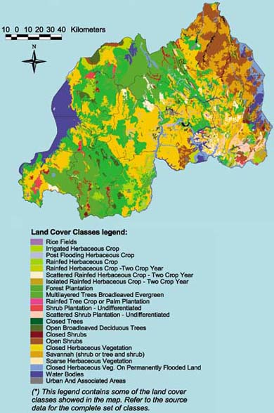
RWANDA LAND COVER MAP

ASIACOVER
The renewable natural resources of many Asian countries have come under severe strain over the past two or three decades. Whilst a large amount of data related to land cover exists in Asia, most are not consistent over large geographic areas and therefore cannot be aggregated at regional and/or sub-regional scale, limiting their use.
Hence, the new ASIACOVER Project, which is based on the Africover project and will be part of GLCN, will develop a regional, standardized land cover map and database, integrated with socio-economic information and decision-aid systems for the development of an integrated approach for environmental monitoring, food security and sustainable development.
GTOS INVOLVEMENT
The new GTOS Programme Director, Mr John Latham, is the main coordinator of the GLCN and Africover projects. GTOS will become more involved in these activities, especially as they are so relevant to its objectives.
www.africover.org
www.asiacover.org
www.fao.org/waicent/faoinfo/sustdev/2002/EN0802_en.htm