![]()
![]()
![]()
2.1 Agroclimatic zones and livestock carrying capacity
2.2 Livestock production systems
2.3 Kajiado Massailand: The biophysical environment and infrastructure
References
The Kenyan rangelands support a wide range of livestock production systems. Differences between the systems arise from the interaction of many factors, including the biophysical environment, tribal differences, population density, level of economic development and incorporation into the market economy. This chapter briefly reviews some of these factors as they relate to current livestock populations and production strategies in the Kenyan rangelands, with particular emphasis on pastoralists. It places the Maasai in a broader context and assesses their importance to livestock production in Kenya. It also briefly describes the climate, physiography, animal populations and infrastructure of Kajiado District, the focus of this study.
Relationships between climate, vegetation and land-use potential have long been used to assess the suitability of land for different uses1. The major elements of climate that affect herbage growth are the intensity and duration of rainfall, the ratio between annual rainfall and potential evaporation, and the year-to-year variation in rainfall.
1 See Pratt and Gwynne (1977) and Sombroek et al (1982) for reviews.
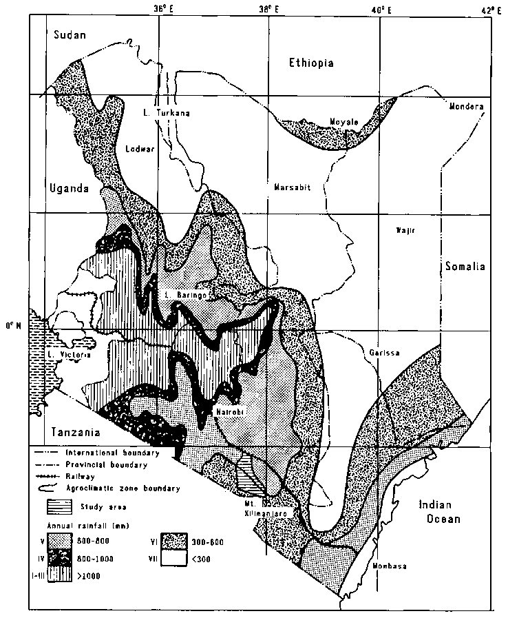
Kenya has been divided into seven agroclimatic zones using a moisture index (Sombroek et al, 1982). The index used is annual rainfall expressed as a percentage of potential evaporation (Eo). Areas with an index of greater than 50% have a high potential for cropping, and are designated zones I, II and III. These zones account for 12% of Kenya's land area. The semi-humid to arid regions (zones IV, V, VI and VII) have indexes of less than 50% and mean annual rainfall of less than 1100 mm. These zones are referred to in this chapter as the Kenyan rangelands and account for 88% of Kenya's land area (Table 2.1; Figure 2.1).
Table 2.1. Moisture availability zones in the Kenya rangelands.
|
Zone |
Classification |
Moisture index (%) |
Annual rainfall (mm) |
Per cent of Kenya's land area |
|
IV |
Semi-humid to semi-arid |
40-50 |
600-1100 |
5 |
|
V |
Semi-arid |
25-50 |
450-900 |
15 |
|
VI |
Arid |
15-25 |
300-550 |
22 |
|
VII |
Very arid |
<15 |
150-350 |
46 |
Source: Sombroek et al (1982).
The seven agroclimatic zones are each subdivided according to mean annual temperature to identify areas suitable for growing each of Kenya's major food and cash crops (Jaetzold and Schmidt, 1983). Most of the high-potential areas are located above 1200 m altitude and have mean annual temperatures of below 18°C; 90% of the semi-arid and arid zones lie below 1200 m and have mean annual temperatures ranging from 22° to 40°C.
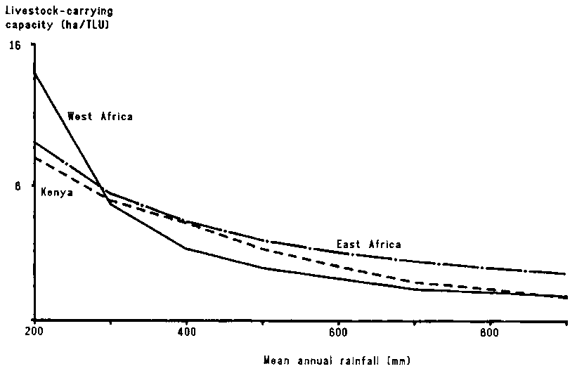
Estimates of livestock-carrying capacity are usually derived directly from rainfall parameters or are linked to productivity of the vegetation (primary production). Several relationships based on annual rainfall have been proposed (Figure 2.2). According to these, average livestock carrying capacity increases from about 7 ha/tropical livestock unit (TLU)2 in the south of Kajiado District (average annual rainfall of 300 mm) to about 3 ha/TLU in the north (average annual rainfall of 550 mm)3. More detailed information on carrying capacity in the ILCA study area is given in Chapters 4 (The study area: Biophysical environment) and 10 (The long-term productivity of the Maasai livestock production system), which discuss short-term and long-term trends in seasonal rainfall and the resulting fluctuations in grazing resources, carrying capacity and safe stocking rates.
2 A tropical livestock unit is equivalent to 250 kg liveweight.3 The relationship between median rainfall (MR, mm) and net primary productivity (NPP, kg DM/ha) is:
NPP = -1000 + 7.5 MRCarrying capacity is calculated by assuming that only 33% of the NPP is consumed by livestock, which gives a daily herbage allowance of 20 kg DM/TLU per day. For further details on safe stocking rates and herbage allowance, see sections 4.4.3: Carrying capacity and 10.1.1: Fodder resources.
While the daily management of herds and flocks aims at satisfying the immediate requirements of livestock for feed and water, longer-term strategies of grazing management are closely linked with the longer-term variations in the forage supply (See Section 5.3: Water utilisation, grazing patterns and stocking rates).
Figure 2.1. Agroclimatic zones in Kenya.
Although potential grazing resources are largely associated with the overall climatic and edaphic conditions, the actual resources available at any particular time are a product of current seasonal rainfall patterns (both spatial and temporal), modified by the extent to which they have been grazed by both domestic and wild herbivores in the recent past. Thus, actual biomass production is much influenced by the current plant cover density, the spatial distribution of which is largely a function of past use (van Wijngaarden, 1985; de Leeuw and Nyambaka, 1988). In addition, the intensity with which grazing resources are used is directly related to the location of water points and the rate at which these supply water, factors that, to a large extent, determine the siting of settlements and the grazing areas of the livestock associated with them.
In summary, there are four interconnected factors that determine the long-term availability of grazing resources in pastoralist production systems:
· variability in rainfall;
· the efficiency with which rainfall is converted into usable forage;
· the use of grazing resources by the domestic and wild herbivores; and
· the relationship between quantity and quality of the resources.
In Chapter 4 (The study area: Biophysical environment) these components are discussed further in relation to the environment of eastern Kajiado, in which the study area is located.
There are two important livestock production systems in the high-potential areas (zones 11 and III). In the first, small farmers rear cattle and smallstock as part of a mixed-farming enterprise. Many are commercial dairy farmers; there are 2 million grade cattle in these zones. The second system consists of a few large farms and ranches developed during the colonial era. Many of these are being divided into smaller units and their importance is diminishing. These zones cover 58000 km2, with a stocking rate close to 1 ha/TLU. Nearly half of Kenya's cattle are found in these zones; the rest are in the rangelands (Table 2.2).
There are three main livestock production systems in the medium-potential rangeland areas: smallholder mixed farming, ranching and pastoralism. The smallholders own a few cattle, a pair of work oxen and some smallstock as important components of their mixed farms. This system accounts for at least a quarter of a million households owning close to one million cattle and 3 million smallstock (Table 2.2). Commercial ranches are important in drier areas, particularly in Laikipia and Machakos Districts and along the coast4. The pastoralists are now mostly organised into group ranches. They own 90% of the cattle in Narok and Kajiado Districts, and about 40% of the cattle in Baringo in the west and in the coastal districts in the east. Their livestock holdings are estimated at 1.7 million cattle and 3.3 million smallstock (Table 2.2).
4. Commercial ranches include individual ranches (owner-occupied ranches with private freehold title to land), company ranches (shareholder units with leasehold rights to land Use) and cooperative society ranches (with membership from neighbouring mixed-farmers on leasehold rangelands). For more details see Bernsten and Jacobs (1983).
Table 2.2. Livestock populations by zones and production systems1.
|
Production system |
Population ('000 head) |
||
|
Cattle |
Sheep |
Goats |
|
|
High-potential areas (zones I, II and III) |
|
|
|
|
Smallholders |
4830 |
1440 |
1380 |
|
Commercial enterprises |
390 |
240 |
|
|
Total |
5220 |
1680 |
1380 |
|
Medium-potential rangelands (zones IV and V, part of zone VI) |
|
|
|
|
Smallholder mixed farming |
960 |
1000 |
2170 |
|
Commercial ranching2 |
1230 |
300 |
|
|
Pastoralists (including group ranches) |
1680 |
1630 |
1710 |
|
Total |
3870 |
2930 |
3880 |
|
Low-potential rangelands (zone VII, part of zone VI) |
|
|
|
|
Pastoralists |
1840 |
2020 |
2470 |
|
Grand total |
10930 |
6630 |
7730 |
1 Derived from Sloane (1986) who used corrected data from the 1983 census by the Animal Production Division of the Ministry of Agriculture and Livestock Development.2 Adapted from Bernsten and Jacobs (1983).
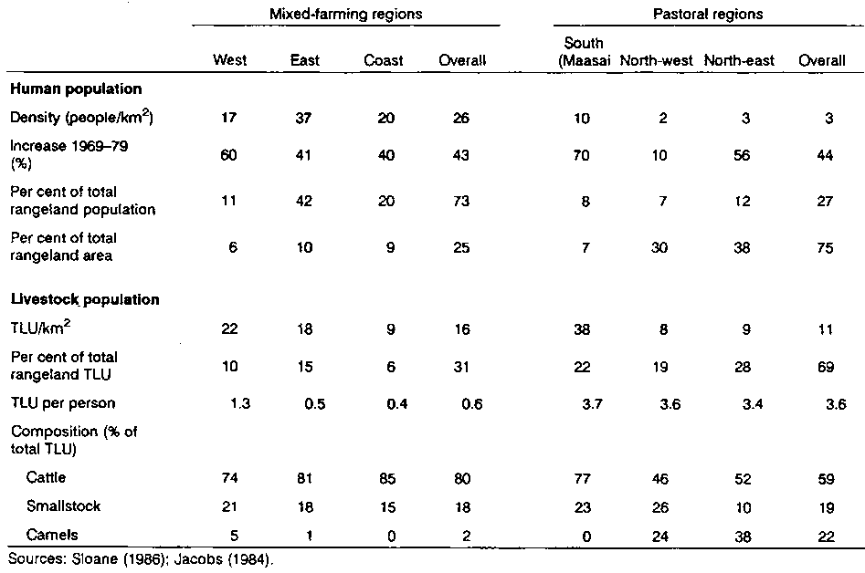
Some 4.4 million people live in the Kenyan rangelands. Of these, 73% live in the 25% of the rangelands that is under smallholder mixed farming. This area is thus quite densely populated (26 people/km2). However, only 30% of the livestock in the rangelands are found in the area under mixed farming and consequently the ratio of livestock to people is low (0.4 to 1.3) (Table 2.3). In contrast, in pastoral regions the human population density is low and the number of livestock per person is higher (Table 2.3). The 'Maasai' pastoral districts are in medium-potential areas (mainly zones IV and V) and support three to four times as many people and livestock per unit area as the pastoral districts in the north-west and north-east, which are mainly in the arid zone. However, ratios of livestock to people tend to be similar (Table 2.3).
Cattle account for up to 85% of the livestock units in mixed farming areas, compared with 77% in the Maasai areas and less than 50% in the drier regions of the north-west and north-east. Smallstock account for most of the remaining livestock units in mixed farming areas and the Maasai areas. In contrast, camels account for up to 38% of livestock biomass in the drier areas.
Between 1968 and 1981 the number of cattle in the Kenyan rangelands increased by an average of 24%. However, the change in cattle population differed markedly between regions. The fall in cattle numbers in Baringo, West Pokot and the north-east region was due to the 1973/74 drought, security problems along the western border and rapid bush encroachment which reduced cattle-carrying capacity (Conant, 1982).
Over the same period the number of smallstock in the rangelands increased by 50%, compared with the average increase of 38% for Kenya as a whole. The largest increase was recorded in the Maasai districts, where the number of smallstock tripled in 13 years, increasing the smallstock-to-cattle ratio (in head) from 0.8 to 1.6.
The ratio of livestock (in TLUs) to people in Kenya fell between 1969 and 1979 as a consequence of rapid increases in the human population. The human population increased by 39% in Kenya as a whole (3.4% per annum), by 43% in the rangelands and by 70% in the Maasai districts (Jacobs, 1984). Large increases in the human population were also recorded in the mixed-farming districts (particularly Laikipia, where the population doubled) and the north-eastern pastoral zone. In the pastoral north-west, the human population grew by only 10 %.
In summary, the ratio of livestock to people has been falling in Kenya since 1968, if not before. This decline was exacerbated by the 1983/84 drought, which reduced the cattle population substantially (Mbugua, 1986).
Table 2.3. Rangeland, people, land and livestock by region in the Kenyan rangelands.
2.3.1 Physiography
2.3.2 Climate
2.3.3 Vegetation
2.3.4 Water resources
2.3.5 Herbivore population
2.3.6 Infrastructure
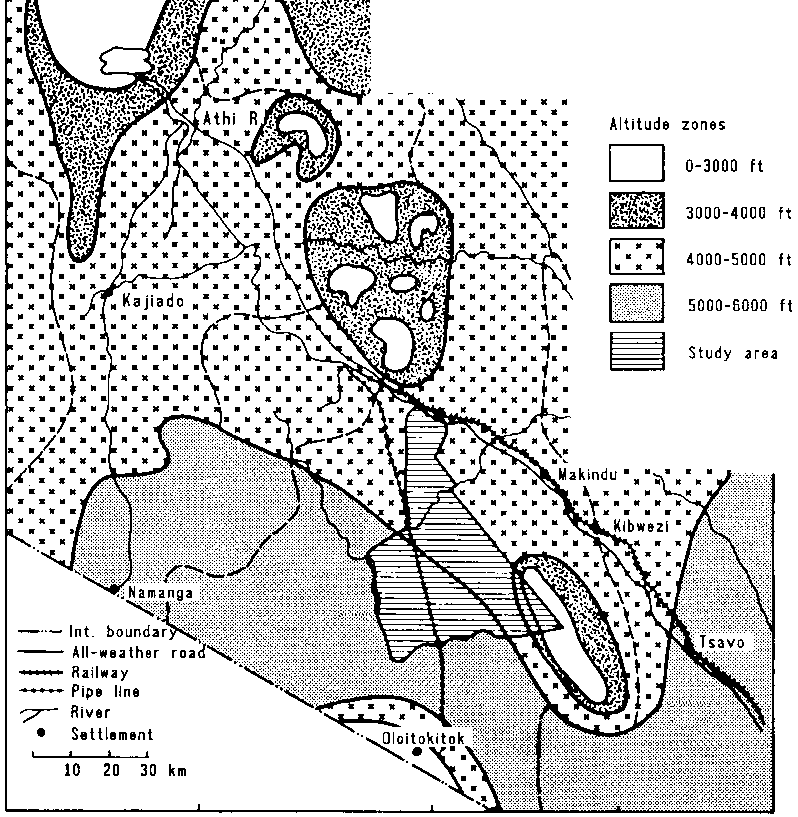
Kajiado District has an area of 19600 km2 (CBS, 1981). It is roughly triangular, and is bordered by the Nairobi-Mombasa railway to the north-east, the border with Tanzania to the south, and the western wall of the Rift Valley to the west. The eastern boundary is formed by the Chyulu Range and western limit of Tsavo National Park. The District has been divided into four ecozones: the Rift Valley, the upland Athi Kapiti Plains, the Central Hills, and the Amboseli Plains (Republic of Kenya, 1982). The study area is in the centre of the Amboseli ecozone, occupying about one quarter of the ecozone's area (Figure 2.3).
The Rift Valley
The Rift Valley runs from north to south and is generally 5060 km wide. The geology is predominantly quaternary volcanics. The floor of the Valley is step-faulted, and comprises a series of horsts running north and south with flat bottomlands between them. The numerous rocky scarps and slopes have shallow, reddish-brown, stony clay-loams. The bottom lands have deeper and more varied soils, including alluvial deposits. The broken and rocky terrain restricts access to much of this ecozone.
The Athi-Kapiti Plains
The upland Athi-Kapiti Plains are mainly open, rolling land. The Plains drain towards the Athi River basin in the east. Geologically, they derive from volcanics but there is a band of tertiary sediments running south-west to north-east across the centre of the plains. The soils are mostly deep black Vertisols.
The Central Hills
At the south-eastern edge of the Athi-Kapiti Plains the land falls away more steeply to the east. Numerous gneiss and limestone hills protrude from the slope, the largest, on the southern boundary, rising to 2800 m. Soils are red, sandy and often shallow. In the eastern part of the zone, the land is much dissected and divided by water courses that drain into the north-easterly flowing Kiboko River, a tributary of the Athi River.
Figure 2.3. Ecozones in Kajiado District
The Amboseli Plains
The Amboseli Plains are divided into two distinct parts. The western half is, geologically, an extension of the basement system in the Central Hills. It is an area of gently undulating plains with deep, reddish-brown clay loams and a variety of poorly drained Vertisols. In the eastern part of the plains the geology changes abruptly to quaternary volcanics with deep, well-drained soils, many of which are very rocky. In the western lee of the Chyulu Range much of the land is covered by lava flows. Most of the western part of the plains drains into the Kiboko River. The eastern plains drain south-eastwards into the headwaters of the Tsavo River5.
5 For more information on geomorphology and soil see Sombroek et al (1982). For more detail on vegetation and soils in the study area see Touber (1983).
Most of Kajiado District lies in the semi-arid and arid zones (zones V and VI) (Table 2.4; Figure 2.4). Only 8% of the District's land is classified as having some potential for rainfed cropping (zone IV): most of this is in the Athi-Kapiti Plains, close to Nairobi, and in the south of the District, along the Kilimanjaro foothills.
Mean annual rainfall ranges from 300 to 800 mm. Rainfall is bimodal, with "short rains" from October to December and "long rains" from March to May. The distribution of rainfall between the two seasons changes gradually from east to west across Kajiado District. In eastern Kajiado more rain falls during the "short rains" than during the "long rains". In western Kajiado the majority of rain falls during the "long rains" (Table 2.5).
Table 2.4. Distribution of agroclimatic zones in the four ecozones of Kajiado District
|
Ecozone |
Per cent of ecozone land area in zone: |
|||
|
IV |
V |
VI |
Total area |
|
|
Rift Valley |
7 |
71 |
23 |
6850 |
|
Athi-Kapiti |
31 |
69 |
|
2040 |
|
Central Hills |
14 |
69 |
27 |
4400 |
|
Amboseli |
15 |
26 |
69 |
6270 |
|
Kajiado District |
8 |
56 |
36 |
19560 |
Source: Adapted from Republic of Kenya (1982).
The short-term (1980-84) distribution of rainfall in eastern Kajiado is discussed further in Section 4.3: Climate. Its impact on primary productivity and grazing resources is discussed in Section 4.4: Rangeland productivity. The longer-term implications of rainfall variability and resulting cyclic changes in rangeland carrying capacity and herd productivity are dealt with in Chapter 10: The long-term productivity of the Maasai livestock production system.
Figure 2.4. Agroclimatic zones of south-eastern Kenya.
Table 2.5. Mean monthly rainfall (mm) for four rainfall stations1 in Kajiado District
|
|
Rainfall (mm) |
|||
|
Simba |
Kajiado |
Namanga |
Magadi |
|
|
October |
5 |
14 |
14 |
13 |
|
November |
135 |
49 |
47 |
38 |
|
December |
99 |
37 |
55 |
30 |
|
January |
21 |
26 |
40 |
23 |
|
February |
11 |
28 |
49 |
46 |
|
March |
50 |
57 |
58 |
60 |
|
April |
108 |
110 |
147 |
111 |
|
May |
27 |
53 |
57 |
41 |
|
Annual total |
528 |
463 |
584 |
545 |
|
No. of years |
44 |
46 |
27 |
43 |
1 For locations see Figure 2.5.
Source: Bille and Heemstra (1979).
Open grasslands predominate in the Athi-Kapiti Plains and many parts of the Amboseli ecozone. Bush and woodland are found mostly in the Central Hills and in the western part of the Amboseli ecozone. Forest is rare and mostly confined to isolated remnants on hill crests and on the lava flows in the Chyulu range (Table 2.6).
Several grassland types have been distinguished:6
6 The first two types are akin to the Themeda and Chloris types identified by Rattray (1960). Their distribution is mainly related to altitude (Themeda at 1100-200 m; Chloris at 450-1200 m). The Pennisetum and Sporobolus types are found mostly under specific edaphic conditions (see Section 4.2: Landscapes, soils and vegetation).· the Themeda-Acacia drepanolobium type in the Athi-Kapiti Plains and the volcanic plains in the north of the Rift Valley (McDowell et al, 1983; Croze, 1978).
· Digitaria-Chloris types in the plains in eastern Kajiado.
· Pennisetum species on floodplains and bottomlands with Vertisols.
· Sporobolus types on saline-sodic clays in the Amboseli ecozone.
There are four main types of bush and woodland:
· Tarconanthus types on shallow soils in the northern Rift Valley.· Semi-deciduous bushland with Combretum, Grewia, Acacia, Rhus and Premna species on hill slopes in wetter areas (zone IV)
· Acacia-Commiphora bush and woodland in the Central Hills and western Amboseli where shallow soils overlie basement complex parent material.
· Open Acacia tortilis woodland on lacustrine plains in part of the Amboseli ecozone (de Leeuw et al, 1986).
The semi-deciduous bushland has many species in common with Acacia-Commiphora bushland, of which it can be considered a variant found in moister areas. A more detailed description of the vegetation of the study area is given in Chapter 4 (Section 4.2: Landscapes, soils and vegetation).
There are few permanent natural sources of surface water in Kajiado District. The main ones are the Uaso Nyiro River in the Rift Valley, two streams in the northern part of the Athi-Kapiti Plains, the Kiboko River7, which drains much of the Central Hills and the northern part of the Amboseli ecozone, and several springs in the southern part of the Amboseli zone.
7 The Kiboko River is not strictly a permanent source of surface water, but water is available year-round from shallow wells in the river bed.
Table 2.6. Percentage of land area under vegetation of different types in the four ecozones of Kajiado District.
|
Woody cover |
Per cent of area |
|||||
|
Vegetation type |
Rift Valley |
Athi-Kapiti Plains |
Central Hills |
Amboseli Plains |
Total |
|
|
0-2 |
Open grassland |
9 |
71 |
14 |
37 |
26 |
|
2-20 |
Wooded and bushed grassland |
74 |
|
10 |
|
26 |
|
20-40 |
Bush and woodland |
16 |
29 |
75 |
59 |
44 |
|
> 40 |
Forest and other types |
1 |
|
1 |
4 |
2 |
Source: Based on Croze (1978) and Republic of Kenya (1982). Both of these used data collected in the early 1970s, before the 1974-76 drought. Woody cover fell substantially during and after the drought and Touber (1983) gave much lower estimates of the proportion of bush and woodland in the Amboseli plains.
Water development
This lack of permanent sources of surface water led to the construction of several small dams and the drilling of a large number of boreholes. At least 290 boreholes were drilled between 1938 and 1982, 43% of them between 1970 and 1982.
Most of the boreholes in the Rift Valley are in the eastern half of the Valley; the Uaso Nyiro River provides water to the western side of the Valley. In the Athi-Kapiti ecozone most boreholes are clustered at the northern end, where general development has been greatest. In the Central Hills the greatest density of boreholes is close to the railway, again where development is furthest advanced.
Most boreholes in the Amboseli ecozone are in the western part, where there is no permanent source of surface water. The volcanic plains have permanent surface water from springs and thus have fewer boreholes. The most important single structure in this ecozone, in terms of provision of water to the Maasai, is the pipeline that cuts through the centre of it from the Kilimanjaro foothills to Sultan Hamud on the Nairobi-Mombasa road. There is a second, much smaller, pipeline system in the north of the Amboseli National Park; this was built in the mid-1950s to compensate the Maasai for loss of grazing land when the Park was demarcated.
No one knows how many of the boreholes and dams in Kajiado District still function. Many dams have silted up or have been washed away; the location of others has been forgotten (Dietz et al, 1986). Most of the older boreholes have broken down. Dietz et al (1986) stated that:
"The County Council has been involved in water development and owns 36 boreholes scattered over the district. The County Council used to take care of the maintenance of these boreholes, but since the Council lost its main source of income (revenues from Amboselli due to the fact that it was turned from a Game Reserve into a National Park), they are financially unable to do so. The Ministry of Water Development (MoWD) was approached to take over the County Council boreholes, but because of the high costs involved, they are as yet also unable to do so.
Although the information about water facilities is not very clear it appears that the MoWD currently operates 7 functioning boreholes and 5 dams. Within the district also a number of individually owned boreholes are operating, but it seems obvious that the existing and functioning water facilities are far too few to serve the population and their livestock. Running costs and maintenance are major problems. Most boreholes are equipped with an electric or a diesel pump and, thus, have high running costs. Another problem seems to be that the local people have never really participated in construction and running of the water facilities and as such do not feel themselves responsible for the maintenance of the facilities. " (Dietz et al, 1986; page 13).
Estimates of livestock and wildlife populations are notoriously inaccurate. Regular ground counts and aerial surveys can, however, indicate long-term population changes. Ground census data show that the number of cattle in Kajiado District rose from 410000 head in 1976 to 690000 head in 1983 (Sloane, 1986). This represents the recovery of the cattle population following the 197476 drought. Estimates from aerial surveys were substantially lower, averaging 360000 during the 1974-76 drought (Croze, 1978) and 412000 over the period 1977-83, with a maximum of 510000 head (Table 2.7). Differences between aerial survey counts were considerable, but the rising trend apparent from ground counts was not obvious from the aerial inventories.
Most authorities agree that the number of smallstock in Kajiado District is increasing. Bernsten and Jacobs (1983) reported an increase from 168000 head in 1968 to 600000 head in 1981. The 1983 population of 1.2 million head reported by the Ministry of Agriculture and Livestock Development is, however, questionable (Sloane, 1986). Aerial inventories indicated average populations of 370000 head in 1974-76 and 518000 head between 1977 and 1983, with a peak of 718000 head (Table 2.7).
Wild herbivores have been surveyed frequently and their populations appear to be more stable than those of domestic herbivores. They comprise about 22% of the total livestock biomass in Kajiado District (Table 2.8). However, wild herbivores are unevenly distributed over the District: In 1974-76 they accounted for 37% of biomass in the Athi-Kapiti Plains and 29% in the Amboseli zone, but only 8% in the Central Hills (Croze, 1978). The major species in terms of biomass are wildebeest, zebra, giraffe and eland (Table 2.9).
Table 2.7. Estimated domestic livestock populations in Kajiado District, 1977-83.
|
Species |
Domestic livestock population |
||||
|
Mean |
Minimum ('000) |
Maximum ('000) |
|||
|
TLU ('000) |
Per cent of biomass |
Head ('000) |
|||
|
Cattle |
296.6 |
86 |
412 |
332 |
510 |
|
Smallstock |
37.3 |
11 |
518 |
319 |
718 |
|
Donkeys |
9.5 |
3 |
16 |
9 |
27 |
Source: Derived from Peden (1984), who summarised aerial-survey inventories of livestock and wildlife population carried out by KREMU between 1977 and 1983. The figures in Tables 2.7, 2.8 and 2.9 represent the combined estimates for several surveys.
Table 2.8. Estimated herbivore biomass density (TLU/km2) in Kajiado and the Amboseli ecozones.
|
|
Estimated herbivore biomass density |
||
|
Kajiado District |
|
Amboseli ecozone |
|
|
1974-76a |
1977-83b |
1974-76a |
|
|
Domestic herbivores |
14.3 |
17.5 |
11.4 |
|
Wild herbivores |
4.0 |
5.0 |
4.0 |
|
Total |
18.3 |
22.5 |
16.0 |
Source: a Croze (1978); b Peden (1984).
Table 2.9. Estimated major wild herbivore populations in Kajiado and the Amboseli ecozones.
|
|
Kajiado Districta |
Amboseli ecozoneb |
||
|
Number (000 head) |
Per cent of biomass |
Number ('000 head) |
Per cent of biomass |
|
|
Wildebeest |
43 |
22 |
11 |
15 |
|
Zebra |
22 |
18 |
4 |
10 |
|
Eland |
7 |
10 |
4 |
15 |
|
Giraffe |
8 |
25 |
3 |
27 |
|
Other wildlife |
|
25 |
|
33 |
Source: a Peden (1984); b Croze (1978).
Between 1977 and 1983 the average stocking rate in Kajiado District, based on aerial inventories, was 4.5 ha/TLU (Table 2.8). However, if the fluctuations in domestic herbivore populations indicated by ground counts reflect reality, total stocking rates varied from 2.7 to 5.4 ha/TLU8 over that period.
8 Based on the data from the Animal Production Division, Ministry of Agriculture and Livestock Development. Sloane (1986) calculated the stocking rate of domestic herbivores in Kajiado District for 1983 at 31 TLU/km2 or 3.3 ha/TLU.
Over the last 30 years, the human population of Kajiado District has increased four-fold, or by 4.7% a year (Republic of Kenya, 1982). At least half of this increase was due to immigration. In 1979 the population of Kajiado District was estimated at 149,000, or an overall density of 7.6 people/km2; the population density in pastoral areas was approximately 5 people/km2 (CBS, 1981). Detailed statistics on the distribution of Maasai pastoralists are given in Chapter 3 (Section 3.4: The socioeconomic impact of group ranches in Kajiado Maasailand). By 1979 about a quarter of the population was non-Maasai, up from just a few per cent in 1949.
The economy of Kajiado District is still dominated by the Maasai, who are largely pastoralists, but rainfed farming, largely by non-Maasai, has taken over as the major economic activity in higher potential areas. Irrigated cropping has also been increasing along river valleys and in swampy areas. The main areas for irrigated cropping are along the Ngong Hills, along the Lolturesh River in the Kimana area, in the Kilimanjaro foothills and around Namanga.
Other major economic activities include the Amboseli National Park and mining of soda from Lake Magadi. The National Park is a major tourist attraction, but provides no revenue for the District and generates little employment for the local people. The soda mine employs about 600 people, but most employees are immigrants from other districts.
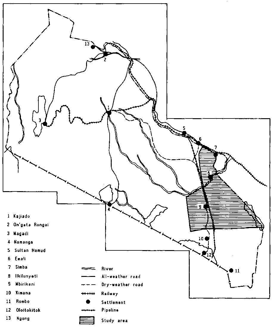
Kajiado District is well served by a network of all-weather roads and by railways (Figure 2.5). In addition, numerous roads that are passable in the dry season penetrate the interior of the District. This network effectively links the urban and trading centres in the District, and public transport is quite readily available.
By virtue of its proximity to Nairobi, Kajiado District is able to supply this major meat consumption centre. However, the District's livestock marketing system is well developed only for cattle. Only the western and northern parts of Kajiado seem to supply smallstock to the Nairobi market; there are no smallstock markets in the southern and eastern parts of the District (see Section 9.2.10, Problems of the livestock marketing system).
Figure 2.5. Map of Kajiado District showing location of towns, villages and the study area.
Until 1986 the government set and controlled prices of most commodities, including food and livestock products. However, the government prices were generally applicable only in major towns and trading centres; traders in smaller centres and more remote areas often charged prices 20-30% above those set by the government.
There are more than 100 full primary schools in Kajiado District but among the pastoralists only 40 to 45% of school-age children are enrolled in school. There are also 16 secondary schools. The Maasai Rural Training Centre operates four youth polytechnics with financial backing from the National Council of Churches in Kenya and the government. In 1986 these offered 129 adult education courses, for which 2340 people enrolled; 10% of the people enrolled were women (Dietz et al, 1986).
The District has 3 hospitals, 8 health centres and 22 dispensaries. However, these are mostly underused because they are situated in urban centres and hence are not readily accessible to the pastoralists. Mobile clinics are operated by AMREF and ICROSS (Dietz et al, 1986). Many other non-governmental organisations and foreign assistance programmes operate in the District and provide a variety of support services.
Bernsten R H and Jacobs A H. 1983. Socio-economic aspects of range research in Kenya: A plan for reaching the Ultimate target groups. Ministry of Livestock Development, Nairobi, Kenya. 112 pp. [Available on microfiche from ILCA: Microfiche no. 59573]
Bille J C and Heemstra H. 1979. An illustrated introduction to the rainfall patterns in Kenya. ILCA/Kenya Working Document 12. 57 pp. ILCA (International Livestock Centre for Africa), Addis Ababa, Ethiopia. [ILCA Microfiche no. 16878]
CBS (Central Bureau of Statistics). 1981. The 1979 population census. Ministry of Finance and Planning, Nairobi, Kenya. 95 pp.
Conant F P. 1982. Thorns paired, sharply recurved cultural controls and rangeland quality in East Africa. In: Spooner B and Mann H S (eds). Desertification and development: Dryland ecology in social perspective. Academic Press, London. pp. 111-122.
Croze H. 1978. Aerial surveys undertaken by Kenya Wildlife Management Project: Methodologies and results. Wildlife Management and Conservation Department and UNEP/FAO Wildlife Project, Nairobi, Kenya. 79 pp.
Dietz T. Owiti A P. Brandt J and Otinga J O. 1986. Report of the identification mission for an ASAL programme in Kajiado District. Netherlands Development Organization, Nairobi, Kenya. 35 pp.
Jacobs A. 1984. An overview of population dynamics in Kenya's rangelands (1969-1979). Ministry of Agriculture and Livestock Development, Nairobi, Kenya, and Winrock International Institute for Agricultural Development, Morrilton, Arkansas, USA. 10 pp.
Jaetzold R and Schmidt H. 1983. Farm management of Kenya. Vol. IIC. East Kenya. Ministry of Agriculture, Nairobi, Kenya. 410 pp.
de Leeuw P N and Nyambaka R. 1988. The prediction of rangeland production from rainfall data in arid and semi-arid eastern Africa. In: Pasture Network for Eastern and Southern Africa (PANESA), African forage plant genetic resources, evaluation of forage germplasm and extensive livestock production systems. Proceedings of the Third Workshop held at the International Conference Centre, Arusha, Tanzania, 27-30 April 1987. ILCA (International Livestock Centre for Africa), Addis Ababa, Ethiopia. pp. 260-268.
de Leeuw P N. Peacock C and Cisse M. 1986. The importance of Acacia tortilis pod feeding in smallstock management in Mbirikani Group Ranch, Kajiado District. In: Proceedings of the Fifth Small Ruminant CRSP Workshop, Nairobi, 4-6 November 1986. Small Ruminant Collaborative Research Support Program, Nairobi, Kenya. pp. 233-241.
Mbugua S W. 1986. Monitoring livestock and wildlife in Kenya. In: Hansen R M, Woie B M and Child R D (eds), Range development and research in Kenya. Proceedings of a conference held at the Agricultural Resources Centre, Egerton College, Njoro, Kenya, 1-5 April 1986. Winrock International Institute for Agricultural Development, Morrilton, Arkansas, USA. pp. 413-430.
McDowell R E, Sisler D S. Schermerhorn C, Reed J D and Bauer R P. 1983. Game or cattle for meat production on Kenyan rangelands? Cornell International Agriculture Mimeo 101. Cornell University, Ithaca, NY, USA. 56 pp.
Peden D G. 1984. Livestock and wildlife population inventories by districts in Kenya, 1977-1983. Technical Report 13, Ministry of Tourism and Wildlife, Kenya Rangeland Ecological Monitoring Unit, Nairobi, Kenya. 18 pp.
Pratt D J and Gwynne M D. 1977. Rangeland management and ecology in East Africa. Hodder and Stoughton, London, UK. 130 pp.
Rattray J M. 1960. The grass cover of Africa. FAO Agriculture Studies 49. FAO (Food and Agriculture Organization of the United Nations), Rome, Italy. 168 pp.
Republic of Kenya. 1982. Report prepared for the Wildlife Planning Unit: Amboseli/Lower Rift regional study. Ministry of Tourism and Wildlife, Nairobi, Kenya. 162 pp.
Sloane P. 1986. Population supporting capacity study for Kenya. FAO Internal Report INT/75/P 13. FAO (Food and Agriculture Organization of the United Nations), Rome, Italy. 170 pp.
Sombroek W C, Braun H M H and van der Pouw B J A. 1982. Explanatory soil map and agro-climatic zone map of Kenya. Report E1. National Agricultural Laboratories, Soil Survey Unit, Nairobi, Kenya. 56 pp.
Touber L. 1983. Soils and vegetation of the Amboseli-Kibwezi area. Kenya Soil Survey R6, Ministry of Agriculture, Nairobi, Kenya. 125 pp.
van Wijngaarden W. 1985. Elephants-trees-grass-grazers: Relationships between climate, soil, vegetation and large herbivores in a semi-arid savanna ecosystem. ITC Publication 4. ITC (International Institute for Aerospace Survey ant Earth Sciences), Enschede, The Netherlands. 165 pp.
![]()
![]()
![]()