2.1 When to Use Basin Irrigation
2.2 Basin Layout
2.3 Basin Construction
2.4 Irrigating Basins
2.5 Maintenance of Basins
2.1.1 Suitable crops
2.1.2 Suitable land slopes
2.1.3 Suitable soils
This chapter indicates which crops can be grown in basins, which land slopes are acceptable and which soil types are most suitable. Chapter 7 discusses under which circumstances to choose basin irrigation.
Basin irrigation is suitable for many field crops. Paddy rice grows best when its roots are submerged in water and so basin irrigation is the best method to use for this crop (Figure 7).
Figure 7 Basin irrigation; transplanting paddy rice
Other crops which are suited to basin irrigation include:
- pastures, e.g. alfalfa, clover;
- trees, e.g. citrus, banana;
- crops which are broadcast, such as cereals;
- to some extent row crops such as tobacco.
Basin irrigation is generally not suited to crops which cannot stand in wet or waterlogged conditions for periods longer than 24 hours. These are usually root and tuber crops such as potatoes, cassava, beet and carrots which require loose, well-drained soils.
The flatter the land surface, the easier it is to construct basins. On flat land only minor levelling may be required to obtain level basins.
It is also possible to construct basins on sloping land, even when the slope is quite steep. Level basins can be constructed like the steps of a staircase and these are called terraces (Figure 8).
Which soils are suitable for basin irrigation depends on the crop grown. A distinction has to be made between rice and non-rice or other crops.
Paddy rice is best grown on clayey soils which are almost impermeable as percolation losses are low. Rice could also be grown on sandy soils but percolation losses will be high unless a high water table can be maintained. Such conditions sometimes occur in valley bottoms.
Although most other crops can be grown on clays, loamy soils are preferred for basin irrigation so that waterlogging (permanent saturation of the soil) can be avoided. Coarse sands are not recommended for basin irrigation as, due to the high infiltration rate, percolation losses can be high. (How to determine the infiltration rate of the soil is explained in detail in Annex 2.) Also soils which form a hard crust when dry (capping) are not suitable.
2.2.1 Shape and size of basins
2.2.2 Shape and dimensions of bunds
Basin layout not only refers to the shape and size of basins but also to the shape and size of the bunds. What is the shape of the basin: square, rectangular or irregular? What is the size of the basin: 10, 100, 1000 or 10 000 m2? How high should the bund be: 10, 50 or 100 cm? What is the shape of the bund? These aspects are discussed in the following sections.
The shape and size of basins are mainly determined by the land slope, the soil type, the available stream size (the water flow to the basin), the required depth of the irrigation application and farming practices.
BASIN WIDTH
The main limitation on the width of a basin is the land slope. If the land slope is steep, the basin should be narrow, otherwise too much earth movement will be needed to obtain level basins. Table 1 provides some guidance on the maximum width of basins or terraces, depending on the land slope.
Three other factors which may affect basin width are:
- depth of fertile soil,
- method of basin construction,
- agricultural practices.
If the topsoil is shallow, there is a danger of exposing the infertile subsoil when the terraces are excavated. This can be avoided by reducing the width of basins and thus limiting the depth of excavation.
Table 1 APPROXIMATE VALUES FOR THE MAXIMUM BASIN OR TERRACE WIDTH (m)
|
Slope % |
Maximum width (m) |
|
|
average |
range |
|
|
0.2 |
45 |
35-55 |
|
0.3 |
37 |
30-45 |
|
0.4 |
32 |
25-40 |
|
0.5 |
28 |
20-35 |
|
0.6 |
25 |
20-30 |
|
0.8 |
22 |
15-30 |
|
1.0 |
20 |
15-25 |
|
1.2 |
17 |
10-20 |
|
1.5 |
13 |
10-20 |
|
2.0 |
10 |
5-15 |
|
3.0 |
7 |
5-10 |
|
4.0 |
5 |
3-8 |
Basins can be quite narrow if they are constructed by hand labour but will need to be wider if machines are used so that the machines can easily be moved around.
If hand or animal powered tillage is used then basins can be much narrower than if machines are used for cultivation. If machines are used then it is important to make sure that basin widths are some multiple of the width of the machines for efficient mechanization.
BASIN SIZE
The size of basins depends not only on the slope but also on the soil type and the available water flow to the basins. The relationship between soil type, stream size and size of the basin is given in Table 2. Values are based on practical experience, and have been adjusted in particular to suit small-scale irrigation conditions.
Table 2 SUGGESTED MAXIMUM BASIN AREAS (m2) FOR VARIOUS SOIL TYPES AND AVAILABLE STREAM SIZES (l/sec)
|
Stream size (l/sec) |
Sand |
Sandy loam |
Clay loam |
Clay |
|
5 |
35 |
100 |
200 |
350 |
|
10 |
65 |
200 |
400 |
650 |
|
15 |
100 |
300 |
600 |
1000 |
|
30 |
200 |
600 |
1200 |
2000 |
|
60 |
400 |
1200 |
2400 |
4000 |
|
90 |
600 |
1800 |
3600 |
6000 |
Example of how to estimate Basin Sizes
|
Question: |
Estimate the dimensions of basins, when the soil type is a deep clay loam and the land slope is 1%. As basin construction is mechanized, the terraces should be as wide as possible. The available stream size is 25 l/sec. |
|
Answer: |
From Table 1 the maximum basin or terrace width for a slope of 1% is 25 m (range 15-25 m). |
|
|
From Table 2 the maximum basin size for a clay loam soil and an available stream size of 25 l/sec is 1000 m2. |
|
|
If the total basin area is 1000 m2 and the width is 25 m, the maximum basin length is 1000/25 = 40 m. |
|
Note: |
This example shows how to estimate the maximum basin dimensions. This basin can be made smaller than this if required and still be irrigated efficiently with the available stream size. |
The size of the basin is also influenced by the depth (in mm) of the irrigation application. If the required irrigation depth is large, the basin can be large. Similarly, if the required irrigation depth is small, then the basin should be small to obtain good water distribution. This is further explained in Annex 3.
The size and shape of basins can often be limited by farming practice. Many farms in developing countries are very small and cultivation is by hand. In these circumstances basins are usually small as they are easy to level and efficient irrigation can be attained with relatively small stream sizes.
On the large mechanized farms, basins are generally made as large as possible to provide large uninterrupted areas for machine movements. Basin dimensions are chosen to be some multiple of the width of the machines so as to use the equipment as efficiently as possible. Other reasons to make basins as large as possible are that less land is wasted in this way (less bunds) and large stream sizes and a relatively large application depth can be used.
The shape of the basin can be square, rectangular or irregular. The shape is mainly determined by the slope. On steep and irregular sloping lands, the basins may be long and narrow. The long side of the basin is along the contour line. If the slope and thus the contour line is irregular, the shape of the basin will also be irregular.
IN SUMMARY
|
BASINS SHOULD BE SMALL IF THE: 1. slope of the land is steep BASINS CAN BE LARGE IF THE: 1. slope of the land is gentle or flat |
Bunds are small earth embankments which contain irrigation water within basins. They are sometimes called ridges, dykes or levees. The height of bunds is determined by the irrigation depth and the freeboard. The freeboard is the height above the irrigation depth to be sure that water will not overtop the bund.
The width of bunds should be such that leakage will not occur, and that they are stable.
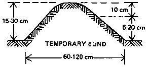
Temporary bunds are normally 60-120 cm wide at the base and have a height of 1.5-30 cm above the original ground surface, including a freeboard of 10 cm (which means an irrigation depth of 5-20 cm). Temporary bunds surround fields on which annual crops are grown; these bunds are rebuilt each season.
Figure 9 Shape and dimensions of permanent bunds
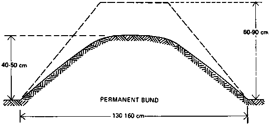
Figure 9 Shape and dimensions of temporary bunds
Permanent bunds usually have a base width of 130-160 cm and a height of 60-90 cm when constructed. The settled height will be 40-50 cm. This settling (compaction of the soil) will take several months.
Permanent bunds are mostly used in rice cultivation, where the same crop is planted on the same fields year after year. The bunds are used as paths in the rice fields as well. Temporary bunds may be used to subdivide the various fields further, for example as indicated in Figure 15.
The following steps are involved in the construction of basins: setting out; forming the bunds; and smoothing the land within the basins.
Step 1: Setting Out
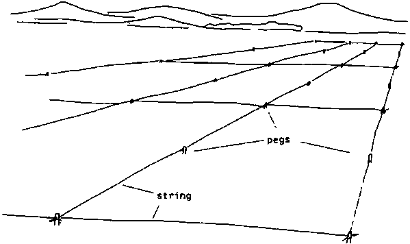
Before construction can begin the location of the basins and bunds must be set out on the ground. This can be done using pegs, string lines or chalk powder to mark the lines of the bunds.
On flat land basins may be square or rectangular in shape (Figure 10). Setting out is relatively simple and involves only straight lines. On sloping or undulating land basins may be irregular in shape and terracing required. Terraces are set out so that the bunds are located along contour lines; the differences in elevation within each basin should not be excessive so that the amount of earth movement required to obtain a level land surface is small (see Table 1).
Figure 10 Setting out the markers
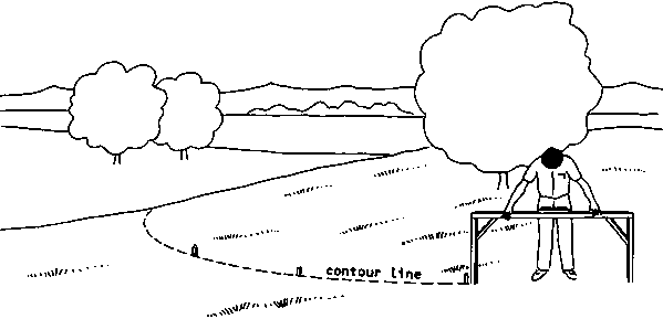
A terrace is set out by first locating a suitable contour line across the land slope (Figure 11; see also Volume 2). This is the line along which the first bund is constructed. A second line is then set out along a contour further up the slope to mark the location of the next bund.
Figure 11 Marking a contour line
Step 2: Forming the bunds
Both temporary and permanent bunds can be formed by hand labour or by animal or tractor powered equipment. When soil is gathered from an area close to the bund a 'borrow-furrow' is formed. This furrow can be smoothed out later or be used as a farm channel or drain. When forming bunds for terraces, soil should only be taken from the uphill side of the bund.
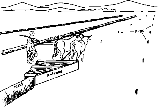
A useful piece of equipment for forming bunds is an A-frame (Figure 12). This consists of two boards set on edge and cross-braced, with a wide opening at the front and a narrow opening at the rear. The boards act as blades for cutting into the soil and crowding it into a ridge or bund (Figure 13). A typical A-frame suitable for drawing by animals has blades 20 cm deep and 2 m long spaced 1.5 m apart at the front and 30 cm apart at the rear.
Figure 12 Wooden A-frame

Figure 13 Making the bunds
Before forming bunds with an A-frame it is useful to loosen the top soil to a depth of 10-15 cm so that the blades can easily collect sufficient soil.
Whichever method is used it is important that the bunds are properly compacted so that leakage cannot occur.
Step 3: Smoothing the land
This can be the most difficult part of basin construction and involves very careful levelling of the land within each basin.
On flat land this involves smoothing out the minor high and low spots so that the differences in level are less than 3 cm. This can be done by hand or by a tractor-drawn land plane depending on the size of the basin. However, 3 cm level differences are almost impossible to judge by eye and only when applying water will it become obvious where high and low spots still exist. Thus several attempts may be required to correct the levelling.
Levelling rice basins can be much simpler. These are first cultivated and then filled with water. As the water surface is level, it will be obvious where the high spots are. These can be smoothed put and the water in the basin gradually lowered to reveal other high areas. The smoothing is usually done by an animal or tractor drawn float. This method of smoothing usually destroys the soil structure. This is not a problem when growing rice, but it is not a recommended procedure for other crops.
On sloping land, where terraces are constructed, levelling is achieved by moving soil from the upper part of the slope to the lower part (Figure 14). Care is needed when filling in the borrow furrow to ensure the bund height is maintained so that overtopping is avoided.
Figure 14 Construction terraces (Construction first bund)
Figure 14 Construction terraces (Levelling 1st field)
Figure 14 Construction terraces (Construction 2nd bund)
There are two methods to supply irrigation water to basins: the direct method and the cascade method.
The direct method
Irrigation water is led directly from the field channel into the basin through siphons, spiles or bundbreaks (see also Annex 1).
Figure 15 shows that "Basin a" is irrigated first, then "Basin b" is irrigated and so on. This method can be used for most crop types and is suitable for most soils.
Figure 15 Direct method of water supply
The cascade method
On sloping land, where terraces are used, the irrigation water is supplied to the highest terrace, and then allowed to flow to a lower terrace and so on. In Figure 16 the water is supplied to the highest terrace (a.1) and is allowed to flow through terrace a.2 until the lowest terrace (a.3) is filled. The intake of terrace a.1 is then closed and the irrigation water is diverted to terrace b.1 until b.1, b.2 and b.3 are filled, and so on.
Figure 16 Cascade method of water supply
This is a good method to use for paddy rice on clay soils where percolation and seepage losses are low. However, for other crops on sandy or loamy soils, percolation losses can be excessive while water is flowing through the upper terraces to irrigate the lower ones. This problem can be overcome by using the borrow-furrow as a small channel to take water to the lower terrace. The lower terrace is irrigated first and when complete the bund is closed and water is diverted into the next terrace. Thus the terrace nearest the supply channel is the last to be irrigated.
When long cascades are used for growing rice it is common practice to allow water to flow continuously into the terraces at low discharge rates. The water demand in the cascade can easily be monitored by observing the drainage flow. If there is no drainage then more water may be required at the top of the cascade. If there is a drainage flow then it is possible to reduce the inflow.
For good crop growth it is very important that the right quantity of water is supplied to the root zone (see also Volume 3: Irrigation Water Needs) and that the root zone is wetted uniformly.
If crops receive too little water, they will suffer from drought stress, and yield may be reduced. If they receive too much water, then water is lost through deep percolation and, especially on clay soils, permanent pools may form, causing the plants to drown. How much irrigation water should be supplied to the root zone - in other words "the net irrigation depth" - has been discussed in Volume 3. How the irrigation water can be evenly distributed in the root zone is explained below, and an example of the evaluation of basin irrigation performance is given in Annex 4.
Ideal wetting pattern
To obtain a uniformly wetted root zone, the surface of the basin must be level and the irrigation water must be applied quickly. Figure 17 shows an ideal wetting pattern: the basin is level and the right quantity of water has been supplied with the correct scream size. As can be seen from Figure 17, it is not possible to have the wetting pattern and root zone coincide completely. The part of the basin near the field channel is always in contact with the irrigation water longer than the opposite side of the basin. Therefore percolation losses will occur near the field channel, if sufficient water is supplied to the opposite side of the basin.
Figure 17 Ideal wetting pattern
Poor wetting patterns
Poor wetting patterns can be caused by:
- unfavourable natural conditions, e.g. a compacted subsoil layer, or different soil types within one basin;- poor layout, e.g. a poorly levelled surface;
- poor management, e.g. supplying incorrect stream size, applying too little or too much water.
i. Unfavourable natural conditions
A compacted sub-soil layer can sometimes occur in a basin some 30-50 cm below the soil surface. Infiltration through this layer may be very slow and so water tends to accumulate above this layer: a "perched" water table is formed (Figure 18). This may result in waterlogging.
Figure 18 A nearly impermeable layer above which a perched water table is formed
This situation may be very helpful for growing rice but will be harmful for other crops. The compacted layer can be removed by using deep ploughs or rippers which break up the subsoil.
Different soil types within a basin can cause very uneven water distribution. This problem can be solved by re-aligning basin boundaries so that each basin contains only one soil type.
ii. Poor layout
Figure 19 shows what happens to the wetting pattern if the soil surface is not level. Some parts of the root zone receive too little water and in the lower parts water may pond or be lost through deep percolation. Plants suffer in the drier parts because they receive too little water and wilt. Plants may also suffer in the wet parts; plant nutrients are carried away from the rootzone to the subsoil and, especially on clay soils, the plants may drown. These faults can easily be corrected by careful land levelling.
Figure 19 Wetting pattern of a poorly levelled basin
iii. Poor management
Figure 20 shows what happens if the basin is irrigated too slowly, by using a stream size which is too small. The part of the basin which receives irrigation water first (near the supply channel) and thus the longest, receives too much water. Percolation losses occur, nutrients are washed away and the plants may drown. The other end of the basin remains too dry. The plants there do not receive enough water and wilt.
Figure 20 Wetting pattern when the flow rate is insufficient
The solution to the problem is to:
- increase the stream size so that the basin will be flooded more rapidly, or- subdivide the basin into smaller basins; smaller basins need a smaller stream size than larger basins.
Figure 21 shows what happens If insufficient water is applied to fill the root zone. This is called "under-irrigation" and is caused by under-estimating the time needed to fill the root zone.
There are no percolation losses during under-irrigation. Although water may be used efficiently by this approach, frequent irrigation will be necessary to meet crop water needs. However, continual under-irrigation will eventually restrict root development and the crop may suffer when there are delays in irrigating, e.g. when water is in short supply or the supply system breaks down.
Figure 22 shows what happens if too much water is supplied to a basin. This is called "over-irrigation". The percolation losses are high, the plant nutrients are washed away and, on clay soils, the plants may even drown. The obvious solution is to apply less water.
Bunds are susceptible to erosion which may be caused by, for example, rainfall, flooding or the passing of people when used as footpaths. Rats may dig holes in the sides of the bunds. It is therefore important to check the bunds regularly, notice defects and repair them instantly, before greater damage is done. Before each growing season, the basins should be checked to see that they remain level. During pre-irrigation it can easily be seen where higher and lower spots are; there should be smoothed out. Also, the field channels should be kept free from weeds and silt deposits.