![]()
![]()
![]()
by
W.B. Mutagyera
Kenya Marine and Fisheries Research Institute, Mombasa
1. ABSTRACT
Crustacea of Kenya have been recognised as a resource of considerable financial value both for the artisanal fisherman and the potential exporter. Palinurid lobsters, penaeid prawns and portunid or mangrove crabs are all caught in shallow water areas by artisanal fishermen who use simple methods like skin diving for lobsters, beach seining and stake traps (“tata” or oozio"). Deeper water species which require more sophisticated equipment cannot be worked by these methods. They have been caught by experimental trawling and this essay presents the observations made on catches of these species including their distribution.
2. INTRODUCTION
Crustacea are an important food resource found in varying quantities along Kenya's coast. Although they rank lower than fish in terms of tonnage, crustacea sell for much more money per unit weight thus outstripping fish in value. Table 1 shows the quantity of crustacea which were landed by commercial fishermen. It will be noted that the north coast is very important in this regard. Table 2 shows the catch and value figures of shallow water crustacea which are taken by artisanal means. Spiny lobsters (Palinuridae), prawns (Penaeidae) and crabs (Portunidae) are all present. Lobsters are caught alive by skin divers, crabs are picked from mud in mangrove areas at low tide while prawns are caught by small scale beach seining and by “tata” or “oozio” (stake traps). Some hand-hauled “juya” trawls are also worked from non-powered vessels.
A history of crustacean exploitation is given by FAO (1966, 1969, 1971) and MUTAGYERA (1978, 1981). The prawn resource of shallow water is discussed by BRUSHER (1974). Taxonomy and biology of shallow water palinurid lobsters has been reported in FAO (1971) and MUTAGYERA (1978).
Penaeid prawn species caught here are:
| Penaeus indicus (Milne Edwards) | 70–90% of total |
| Metapenaeus monoceros (Fabricius) | 15–20% |
| P. semisulcatus (De Haan) | 5–10% |
| P. monodon (Fabricius) | 5–10% |
| P. japonicus (Bate) | 2–5% |
Catch composition may vary with area and month of the year.
Spiny lobster species here are:
Panulirus ornatus (Fabricius)
P. longipes longipes (Milne Edwards)
P. versicolor (Latreille)
P. homarus (Linnaeus)
P. dasypus (Milne Edwards)
P. penicillatus (Olivier)
Of these P. ornatus is the most important and may comprise 90% of the catch with other species coming in the above order of importance. Composition of the catch changes towards the north of the Kenya coast with P. dasypus and P. homarus becoming more important (MUTAGYERA, 1978).
| 1977 | 1978 | 1979 | ||||
| Tonnes | Value | Tonnes | Value | Tonnes | Value | |
| Lamu | 69 | 815 | 110 | 1149 | 88 | 1104 |
| Tana River | - | - | - | - | 6 | 49 |
| Kilifi | 29 | 230 | 34 | 315 | 28 | 418 |
| Mombasa | 41 | 378 | 112 | 1787 | 78 | 1616 |
| Kwale | 27 | 183 | 62 | 513 | 56 | 490 |
| Other South coast | 20 | 146 | - | - | - | - |
| Area not reported | 22 | 262 | 48 | 564 | - | - |
| Type | Weight (tonnes) | Value (Shs). |
| Lobster | 40.24 | 1,065,665.50 |
| Prawn | 31.42 | 94,311.60 |
| Crab | 19.40 | 83,372.00 |
| Total | 91.06 | 1,243,350.10 |
Portunid crab species available include Scylla serrata, Portunus pelagicus and P. sanguinotentus. S. serrata is the most important here. These crabs which are found associated with mangrove swamps are most prevalent in the Vanga and Lamu areas where the mangrove forests are extensive. Other swimming portunid crabs often found in numbers are Charybdis spp. but the individuals of these species are small and thus have little recoverable meat, hence of little food importance. Demand for crab meat is lower than that of lobster and prawns. Consequently fishing for crabs is of lower importance. Studies on this potential resource have also been scarce. Muthiga (pers. comm.) has examined crab taxonomy and identified species of greater food importance.
In addition to these shallow water crustacea, other species are available in deeper water. These include the deep water prawn Heterocarpus woodmasoni, deep water palinurid lobsters Linuparus somniosus, Puerulus angulatus and Palinustus mossambicus. Less important lobster families include the Scyllaridae which is represented here by Scyllarides squamosus, S. tridacnophaga, Ibacus incisus and Thenus orientalis as well as the Nephropidae which is represented by Metanephrops andamanicus. The deep water prawn Heterocarpus woodmasoni, lobsters Puerulus angulatus, Thenus orientalis and Metanephrops andamanicus have been caught by research vessels during experimental trawling.
3. THE ENVIRONMENT
The Kenya coastline has coral formations along it. These take the form of fringing reefs but also as occasional outcrops here and there. The reef continuity is broken by the discharge of fresh water by rivers which create semi-brackish and often muddy environments that do not favour coral growth. These reefs provide the important habitat for spiny lobsters where skin-diving fishermen catch them alive. Prawns are caught commercially by many small scale fishermen who use simple nets and traps near the shore. The presence of coral along the Kenya coast limits the trawlable areas available for ships. The continental shelf is narrow except in the Ungwana Bay area and the North Kenya Banks. These banks have some 1100 square nautical miles of water shallower than 200 m. Most trawling is, however, done for prawns (Penaeus spp.) in the Ungwana Bay area where good trawl grounds shallower than 70 m exist. Indeed, an area shallower than 30 m is relatively extensive here (nearly 350 n.m.2). Deeper than this fishermen do not operate due to the lack of more sophisticated and consequently expensive equipment necessary and the extra skill needed as well as the problem of the steep continental slope. The area where deep-sea crustacea were found is deeper than 200 m and is in an area of turbulence where the East African Coastal Current meets the Somali Current. The Monsoon winds Kenya's coast experiences enhance currents making this area difficult for small boats.
4. DEEP-SEA CRUSTACEANS. CATCHES AND DISCUSSION
As afore said, the trawlable areas on the Kenya coast are limited by coral growths. The fishing could only be done in areas with reasonably smooth bottoms. The deep-sea prawn Heterocarpus woodmasoni, the deep-sea lobsters Puerulus angulatus, Metarephrops andamanicus and the slipper lobster Thenus orientalis were all caught in experimental trawls outside the shallow region. The author accompanied M. V. “Kusi” on fishing trips in 1978/79 and R.V. “Ujuzi” in 1979–81 during which these crustaceans were landed. Prawn catches ranged from as low as 0.1 kg/hr to as high as 200 kg/hr in a few cases. During the Northeast Monsoon the catches were lower than during the Southwest Monsoon. One trip made 292 hauls and gave an2 estimated mean prawn population density of 720 kg/n.m.2 and 244 kg/n.m.2 for lobsters. This was done using shrimp bottom trawls. Beam trawling gave an estimate of 3362 kg/n.m.2 during the same season from 22 hauls. These were only prawns. During the Southwest Monsoon period beam trawling gave a mean estimated yield of 5540 kg/n.m.2 for prawns. Mean density of population worked out at 3.2 tonnes/n.m.2 for prawns and 9.1 tonnes/n.m.2 for lobster, i.e. a total of 3.3 tonnes/n.m.2. The biomass worked out as 145 tonnes for prawns and 5 tonnes for lobster, i.e. a total of 150 tonnes. Maximum sustainable yield was estimated at 108 tonnes for prawns and 2 tonnes for lobsters i.e. a total of 110 tonnes for both groups of crustacea. Although not important for food, swimming crabs, mainly Charybdis smithi were caught. Sometimes the catch was up to 800 kg/hr.
The mean population density estimated for Puerulus angulatus which dominated the lobster catches during the Northeast Monsoon period was about 1.4 tonnes/n.m.2. During the Southwest Monsoon up to 6 tonnes/n.m.2 realised. Some explanation was offered (VNIRO, 1978) in terms of depth migrations from 210–230 m range during the S.E. monsoon down to 300 m during the Northeast Monsoon. However, further trawling by R/V “Ujuzi” did not support this hypothesis. Differences in fishing efficiency equipment seem to be responsible for this. The best catches of Puerulus angulatus taken by R/V “Ujuzi” were made off Malindi banks and Ungwana Bay (catch rates of over 60 kg/hr). On one occasion 400 kg were caught in one hour. The most successful catches came in hauls made during April, July and November using high opening fish and shrimp trawls.
All catches were made in water deeper than 200 m, mainly in the 200-300 m depth range. Apparently populations of P. angulatus are concentrated on rather stony grounds. Although sampling was not random it is apparent that the fishing area is small, therefore a fishery exclusively for these crustaceans would be shortlived. Caught as a by-catch they will nevertheless be welcome addition for the fishermen.
5. ACKNOWLEDGMENTS
I am thankful to the capteins of M/V “Kusi” and R/V “Ujuzi” and their crews for having me accompany them on their trawling cruises. My colleagues Steve Nyambu, Ed Kuyah, Jerry Achuku and Frank de Souza were a pleasure to work with on R/V “Ujuzi”. I can not deny myself the pleasure of thanking the late Mr. Msalem who gave me encouragement albeit posthumously. Finally and most importantly my gratitude is due to Director of Kenya Marine and Fisheries Laboratory, Mr. Allela, the Assistant Director of Fisheries, Mr. J. Mumba and Mr. W.J. Scheffers of FAO under whose joint guidance cruises of R/V “Ujuzi” were organised.
6. REFERENCES
BRUSHER, H.A., 1974. The magnitude, distribution and availability of prawn (Penaeidae) resources in coastal and estuarine waters of Kenya, 1970. J. Mar. Biol. Assn. India 16(2): 335–348.
FAO/UN, 1966. Report to the Government of Kenya on fisheries development possibilities. Based on the work of D.H. Rhodes, FAO/TA Fisheries Development Adviser. Rep. FAO/TA, (2144): 77 p.
FAO/UN, 1969. Report to the Government of Kenya on investigations into pelagic, demersal and crustacean resources off the coast of Kenya. Based on the work of A.M. Barker, Marine Fishery Biologist. Rep./FAO/UNDP/(TA) (2732): 31 + iiiP.
FAO/UN, 1971. Report to the Government of Kenya on the evaluation of Prawn (Penaeidae) and spiny lobster (Palinuridae) Marine resources. Based on the work of H.A. Brusher, Marine, Marine Fishery Biologist. Rep. FAO/UNDP/(TA) (3006) + 40 p.
MUTAGYERA, W.B., 1978. Some observation on the Kenya lobster fishery. E. Afr. Agric. For J. 43(4): 401–407.
MUTAGYERA, W.B., 1981. A review of past research on the edible crustaceans of the East African coast. In Proceedings of the workshop of the Kenya Marine and Fisheries Research Institute on Aquatic Resources of Kenya, Mombasa, Kenya, July 13–19, 1981.
VNIRO, 1978. Western Indian Ocean fisheries resources survey FAO/UNDP/ USSR Co-operative project. Indian Ocean Programme, Development Report No. 46.
by
R.M. Nzioka
Kenya Marine and Fisheries Research Institute
Mombasa, Kenya
The Marine Fisheries of Kenya are supported by pelagic and demersal fish species which are exploited by various crafts and gears. The fishing industry is passing through a phase of changing over from traditional to the modern methods of exploitation, from the use of indigenous sailing crafts and rather less effective gears to mechanised crafts and the larger powered vessels operating with more efficient types of fishing gears and other auxiliary equipment such as radar, fish finders etc. Exploration and harvesting of the Kenya fisheries resources of the ocean and more intensive applied fisheries research is of considerable importance to the country. The objectives of this paper are to present a brief account of the recent findings on the seasonal distribution of the major exploited marine fishery resources, potential resources available for exploitation and on the influence of the monsoons on the availability of fisheries resources.
The ecological relationship between fishes and their environment is of great practical application in fisheries. For any large-scale development of our fishery resources a better understanding of the environmental factors influencing the resources is essential. The marine biological and oceano-graphical investigations in recent years have provided very interesting informations of biological and non-biological factors of the environment. Non-biological factors influencing the fisheries include winds, monsoons, currents, nature of bottom, light, temperature, salinity, nutrients, etc. The influence of the Southwest Monsoon on the surface waters is manifested by lowering the thermocline, along the East African Coast. It has been found that the monsoon intensities have direct influence on the fisheries. In view of this it is desirable to discuss the fluctuations in fisheries.
1. MARINE FISH PRODUCTION
Surveys on marine fisheries resources of Kenya dates back from 1951 when the East African Marine Fisheries Research Organization was formed, during which time the emphasis was on pelagic species. During the surveys on pelagic fishes between 1951 and 1954 catches of 0.52 kg/line/hr were obtained. 22% of the total catch were Scomberomorus commerson (WILLIAMS, 1956). In the same survey it was observed that tunas, especially the yellow fin tuna Thunnus albacares was present throughout the year, but with marked increase during the Souteast monsoon and very close to the shore up to 4 km off-shore. Other tunas which were found in the area were Thunnus alalunga, frigate mackerel Auxis thazard. The dogtooth tuna Gymnosarda unicolor, small tuna Euthynnus affinis and skipjack Katsuwonus pelamis. Although these species were found within the Kenya waters they are unexploited. The billfishes are also an important pelagic group in this area. The striped marlin Tetrapterus audax has been found to form heavy conentrations near the northern tip of Pemba Island and around Malindi. Catch rates have been 0.87 kg/100 hooks/hr and at the peak of the season during the Northeast monsoon catch rates have reached 9.2 kg/100 hooks/hr with average weight of 45 kg per fish. Majority of the catches have been made below the thermocline (22°–23°C). These heavy concentrations during the Northeast monsoon are associated with the post spawning feeding migration. The black marlin, Makaira indica, and the blue marlin, Makaira nigricans, are mostly caught by sport fishermen during the S.E. monsoon close to the shore.
Kenya has a coastline of about 640 km. The annual marine fish production landed along the coast in Kenya for 1978–1981 has been estimated at 4634 (1978), 4070 (1979), 5336 (1980) and 5967 tonnes in 1981. The overall picture of the present status of the exploited marine fish products give an idea of the fluctuations in the fisheries.
In Table 1, some facts on our exploited marine fishery resources are given in order to highlight the trends in marine fish production.
| Year | 1978 | 1979 | 1980 | 1981 |
| Category | ||||
| Demeral | 2220 | 2110 | 2587 | 2831 |
| Pelagic | 1049 | 997 | 1150 | 1103 |
| Elasmobranchs | - | - | 21 | 25 |
| Crustacean | 366 | 256 | 400 | 384 |
| Molluscs | 17 | 26 | 21 | 25 |
Fishing is mainly confined to the coastal waters up to 50 meters depth. At Ungwana Bay, fishing has been extended to groups up to 200 meters for deep water lobsters, prawns and demersal fishes.
The larger pelagic fishes comprise the tuna and tuna-like species and the larger carangids which are caught in large numbers between 15–200 meters depth mostly in June and July. Some of them, especially the round scad Decapterus spp. and horse mackerel Trachurus spp., have vertical migrations, concentrating at the bottom during the day, and rise to the surface as schools in depths between 20 and 40 meters below the surface at dusk. Although there are some good catches of sardines and anchovies, small schooling pelagic fishes are never predominant over large areas as is the case for carangids. The local fishermen catch these fishes using deep nets at night and cast net early in the morning. Demersal fishes of importance comprise rabittfish (Siganidae), the scavengers (Lethrinidae), rock cod (Serranidae), snappers (Lutjanidae). The spiny lobster is common off Ungwana Bay at 200–250 metres in June, July and November.
Decapterus macarellus have been observed to yield 500 kg/hr in June, 532 kg and 1344 kg/hr of D. kiliche in July. The larger carangids Gnathanodon speciosus, Carangoides malabaricus and Selar crumenophthalmus yield between 150–230 kg/hr in July. Spawning grounds of these species have not been located and it is possible that spawning takes place in deeper waters, further offshore. Ripening gonads of the round scads Decapterus spp. are observed in January, July and November, spent gonads are observed in March. It is possible that the carangids have two spawning seasons, April to June and September to October, but the peak of spawning seems to be in May-June along the coastline.
The sardines and anchovies are often caught in substantial quantities of completely different species, suggesting that schools are discrete and locally distributed. The main species caught in Kenya are round herring Etrumeus micropus, which has been observed to give catches of 152 kg/hr in July.
Spanish mackerel, Scomberomorus commerson and S. plurilineatus and Indian mackerel, Rastrelliger kanagurta are caught accidentally in nets. They yield fairly good catches in November-April.
2. DEMERSAL FISH
The red snappers (Lutjanidae) are very prominent in Kenya. Catches of up to 220 kg/hr in December, January and March, particularly on the part of the shelf adjacent to the southern part of North Kenya Banks and Ungwana Bay have been obtained during the surveys by R/V “Professor Mesyastev”. Other times of the year the snappers are scarce on the shelf. The emperors (Lethrinidae) are never particularly abundant and catches of about 40 kg/hr on the shelf was only obtained in January, March and November. The barracudas (Sphyranidae) are very abundant in Kenyan waters, the dominant species being Sphyraena japonicus. In January yields of 1,080 kg/hr to 2,170 kg/hr have been obtained but in July this drops to 114 kg/hr. S. jello has given yields of 13-26 kg/hr in January, June and November.
The grunts (Pomadasyidae) are prominant in Kenya at all times with particularly good catches in November. The silver bellies (Leiognathidae) are very abundant and form dense local schools. Catches of the commonest species Leiognathus equulus are 30–270 kg/hr in January. The goatfishes, Mullidae, especially Upeneus sulphureus yield as much as 1,200 kg/hr in July and 562 kg/hr in November. Other species are more sparsely distributed like U. vittatus with yields of 141 kg/hr in January obtained during the R/V “Professor Mesyasterv” surveys in December 1975-June 1976 and July 1977-December 1977. The spotted sicklefish Drepane punctata found around Malindi gave yields of up to 500 kg/hr during the 1979 to 1981 offshore trawling surveys with R/V “Ujuzi”.
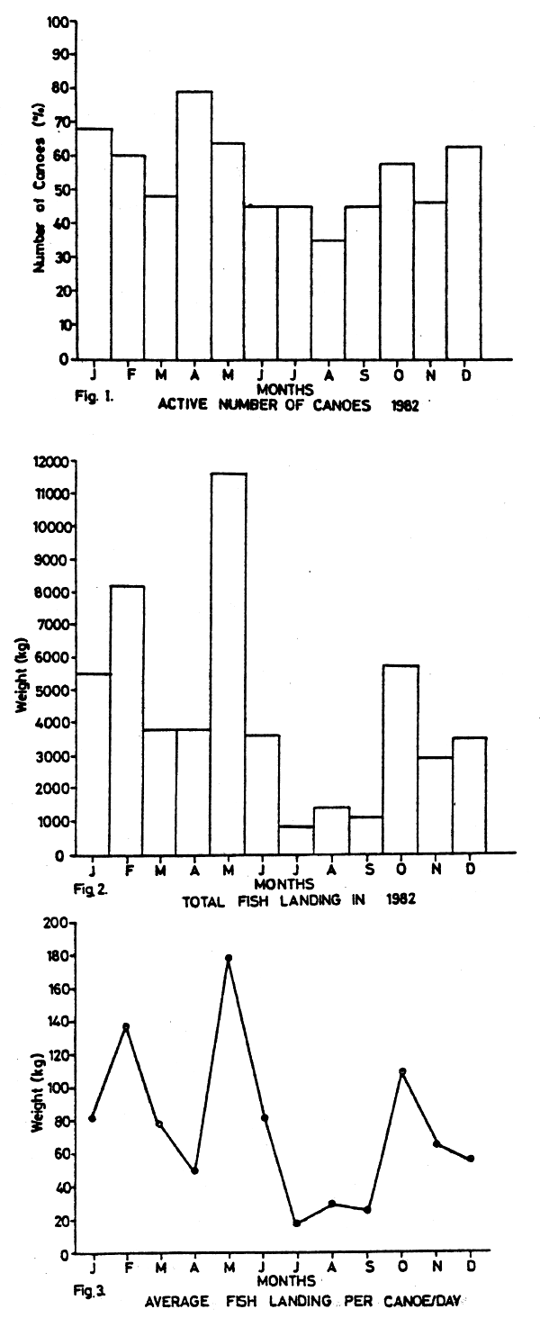
3. THE ARTISANAL FISHERY
The situation of the artisanal fishery may be considered as critical to such an extent that the importance of reliable forecast is very important. A preliminary survey carried out in the Kilifi area aimed at providing an account of the trends of the traditional fishery was started in 1981 by the Kenya Marine Fisheries Research Institute. Data collected over a period of 12 months in 1982 were analysed. The total landing of major groups of fish in 1982 was 51.1 tonnes which showed a monthly variation from 0.76 tonnes in July to 11.6 tonnes in May. The fishermen were estimated to spend 6 to 9 hours a day to fish and land the catch. Minimum time spent at sea was in June and July, which could be attributed to bad weather. During this period few boats ventured into the sea.
The main fishing crafts are canoes, 4–5 metres long, equipped with shark gillnets, traps and handlines. There are two men onboard. From Table 2 it can be seen that a large variety of fishes support the fishery and fish landings could reflect the gear commonly used. In fact some of the gears are designed to catch a particular group of fish such as rabbitfish (Siganidae) which enter traps baited with seaweeds and placed in intertidal langoons. The average annual landing for this group at Kilifi was 25.2 tonnes, forming 49.3% of the total fish landed. These best catches were made in April, May and June. Good catches of rays were landed in January and February when the sea was calm and the fishermen ventured further from shore. Scavengers (Lethrinidae) were abundant from December to February and the kingfish reached a peak in March. The little tuna, Euthynnus affinis, bonito Sarda sarda, sailfish Istiophorus gladius, and the striped marlin Tetrapterus audax were caught in January to March and November to December only, which is due to seasonal migration. Sardines were landed in February when heavy shoals were observed in creeks. There was generally low catches during the Southwest monsoon months (Figs. 1–3) probably due to the weather conditions. Seasonal migrations of fish in and out of the fishing areas and the state of weather conditions at sea restricted most of the fishermen in certain periods. This is the main factor which accounts for the low catches because almost all the kinds of gear and boat used by the fishermen are affected by waves and currents at sea.
4. REFERENCES
ANON., 1982. Offshore trawling Survey in Kenya. UNDP/FAO/KEN 74/023.
BIRKETT, L., 1979. Western Indian Ocean Fishery Resources Survey. Report on the Cruises of R/V “Professor Mesyatsev” December, 1975-June 1976/July 1977-December 1977. Tech. Rep. Indian Ocean Programme (26): 97 pp.
WILLIAMS, F., 1956. Preliminary Survey of the Pelagic fishes of East African Waters. Fish. Publ. London No. 8 p. 68.
Table 2. Monthly catch (kg) composition of artisanal fishermen at Kilifi sampling station in 1982.
| Major fish group | Jan | Feb | Mar | Apr | May | Jun | Jul | Aug | Sep | Oct | Nov | Dec | Total | % |
| Rabbitfish (Siganidae) | 290 | 1320 | 630 | 3040 | 10940 | 2750 | 450 | 960 | 750 | 1120 | 1990 | 940 | 25180 | 49.3 |
| Rays | 1170 | 2810 | 190 | 40 | 290 | 40 | 30 | 40 | - | 410 | 30 | 100 | 8850 | 17.3 |
| Scavengers (Lethrinidae) | 1150 | 350 | 180 | 80 | 60 | 50 | 70 | 20 | 90 | 140 | 210 | 620 | 3020 | 5.9 |
| Kingfish (Scomberomorus spp.) | 240 | 550 | 1410 | 100 | 20 | - | 10 | 20 | 60 | 10 | 50 | 10 | 2480 | 4.9 |
| Sharks | 960 | 960 | 20 | 20 | 30 | 120 | 40 | 80 | 100 | 10 | 20 | 60 | 2150 | 4.2 |
| Tuna (Euthynnus affinis) | 500 | 250 | 560 | - | - | - | - | - | - | - | 90 | 550 | 1950 | 3.8 |
| Sailfish (Istiophorus gladius) | 570 | 430 | 120 | - | - | - | - | - | - | 40 | 50 | 120 | 1330 | 2.6 |
| Sardines (Clupeidae) | - | 1100 | 60 | - | 60 | 40 | - | - | - | - | - | - | 1260 | 2.5 |
| Mullets (Mugilidae) | 90 | 20 | - | 90 | 30 | 180 | 60 | 20 | - | - | 230 | 300 | 1020 | 2.0 |
| Cavallas, Jacks (Carangidae) | 110 | 50 | 10 | 50 | 60 | 150 | 60 | 110 | - | 80 | 80 | 220 | 980 | 1.9 |
| Snappers (Lutjanidae) | 10 | 10 | 400 | 100 | 10 | 40 | 20 | - | 10 | - | - | 30 | 630 | 1.2 |
| Parrotfish (Scaridae) | - | 50 | 180 | 110 | 20 | 10 | 10 | - | 10 | 30 | 110 | 70 | 600 | 1.2 |
| Rock cod (Serranidae) | 70 | - | - | 50 | 10 | 50 | 10 | 20 | - | 20 | 10 | 330 | 570 | 1.1 |
| Grunters (Pomadasyidae) | 30 | 70 | - | 120 | 50 | 60 | - | - | - | - | - | 40 | 370 | 0.7 |
| Marlin (Tetrapterus audax) | 100 | 220 | - | - | - | - | - | - | - | - | - | 10 | 330 | 0.6 |
| Catfish (Tachysurus spp.) | - | 70 | - | - | 30 | 90 | - | 20 | 10 | 10 | - | 30 | 260 | 0.5 |
| Bonito (Sarda sarda) | 110 | 10 | - | - | - | - | - | - | - | - | - | - | 120 | 0.2 |
| TOTAL | 5400 | 8000 | 3760 | 3800 | 11560 | 3580 | 760 | 1290 | 1030 | 5570 | 2870 | 3430 | 51100 |
by
Svein A. Iversen
Institute of Marine Research, Bergen, Norway
ABSTRACT
The Kenyan waters in the depthregion 10–700 m have been surveyed four times by the R/V “Dr. Fridtjof Nansen” during the period 1980–1983. The abundance and distribution of fish was investigated acoustically and by trawling. The estimated fish abundance in the investigated area was rather low. This mainly because the shelf and thereby the productive area is small. The estimated fish biomass was in the range 18000–32000 tonnes. This is an underestimate of the total biomass because waters shallover than 10 m is not covered by the vessel. This is a rather productive and important area where the fishery takes place to day.
The main part of the observed biomass was in waters shallover than 200 m. The highest abundance was observed in the depth 10–50 m. In this depths about 50% of the trawl catches were silverbellies.
These investigations demonstrate that the total catch of marine fish might be increased by extending the fishery beyond the reef. The potential yield of the area beyond the reef was estimated at about 5000–8000 tonnes. However, a rather large proportion of the potential yield is silverbellies which is of limited importance for the market to day. The fish density is generally too low to support trawl and purse seine fishery. Therefore the traditional artisanal fishery should be encouraged to extend into the area beyond the reef.
1. INTRODUCTION
1.1. Programme and objectives
By an agreement between the Government of Kenya and the Norwegian Agency for International Development (NORAD), the fishery research vessel “Dr. Fridtjof Nansen” carried out three surveys in Kenyan waters in 1982 – 1983. In 1980 “Dr. Fridtjof Nansen” carried out a similar survey in a joint programme between Kenyan authorities, FAO (Rome) and NORAD. During these surveys the fish resources in the depth region 10 m to 500/700 m were investigated, and the main hydrographical regime off Kenya was charted.
The timing and the scientific staff of the different surveys are shown in Table 1.1. After each survey a report was presented Anon (1981, 1982a, 1982b, and 1983). Later on the surveys are referred to as number 1, 2, 3 and 4.
1.2. General geographical description.
Kenya's coastline is about 225 nautical miles (400 km) long from the Tanzanian border in the south to the Somalian border in the north. Two main river systems reach the coast, the Galani-Sabaki River just north of Malindi and the Tana River about 45 nautical miles further north. Large fringing coral reefs are found along the coast. The continental shelf (depth down to 200 m) is very narrow except for the North Kenya Bank where the shelf widens to about 50 nautical miles. Beyond the edge of the continental shelf steep gradients lead down to the ocean floor. Mangrove forests and swamps are found in the very south and from the Ungama Bay to the border of Somalia. During the Southwest Monsoon (April-October) the East African Current flows strongly northwards, parallell to the Kenyan coast, bathing the shelf with water which is relatively poor in nutrients. This current originates as a branch of the South Equatorial Current. During the Northeast Monsoon (October-March), there is a complete reversal of the winds and the wind-generated surface circulation, the East African Current is weakened and water flows eastwards as the Equatorial Counter-Current.
Table 1.1. Timing and scientific staff of the four surveys with R/V “Dr. Fridtjof Nansen” in Kenya waters.
| Survey No. | 1 | 2 | 3 | 4 |
| Time | 8–19 DECEMBER 1980 | 12–24 AUGUST 1982 | 7–15 DECEMBER | 2–8 MAY 1983 |
| Staff | NORWAY | NORWAY | NORWAY | NORWAY |
| G. Vestnes+ | T. Stømme+ | S.A. Iversen+ | S.A. Iversen+ | |
| K. Strømsnes | B. Ellertsen | H. Kismul | K. Hansen | |
| Ø. Skåtun | S. Myklevoll | S. Myklevoll | ||
| KENYA | B. Bakken | B. Bakken | B. Bakken | |
| T. Mørk | E. Øvretveit | H. Abrashamsen | ||
| J. Achuku | ||||
| J. Kasai | KENYA | KENYA | KENYA | |
| R. Nzioka | ||||
| R. Ruwa | S.S. Andika | W. Mutagyera | M.M. Kimaro | |
| R. Nzioka | C. Mweu | W. Mutagyera | ||
| USA | D. Opera | M. Obadha | ||
| G. Turiakikayo | A. Ouma | |||
| P.C. Heemstra | ||||
| FAO | ||||
| S.C. Venema |
2. MATERIAL AND METHODS
As shown in Table 1.1, four surveys were carried out along the Kenyan coast with the R/V “Dr. Fridtjof Nansen” during 1980–1983. The survey courses, hydrographical and fishing stations are shown in Fig. 2.1. -2.4. As seen from these figures, the two first surveys covered the widest area due to investigations of the deeper part of the coastal area. For collecting hydrographical data: temperature, salinity and oxygen content, reversible Nansen water bottles were worked at the depths 5, 10, 20, 30, 50, 75, 100, 125, 150, 200, 250, 300, 400 and 500 m. Samples from the sea surface were collected by a bucket. No hydrographical data were collected during the first survey in 1980 (Fig. 2.1.). During the second survey four hydrographical sections were worked perpendicular on the coast line (Fig. 2.2.). These sections were repeated during the third survey (Fig. 2.3.). During the last survey the three northern sections were repeated and a rather dense net of stations for observing temperature and salinity at the surface was added (Fig. 2.4.).
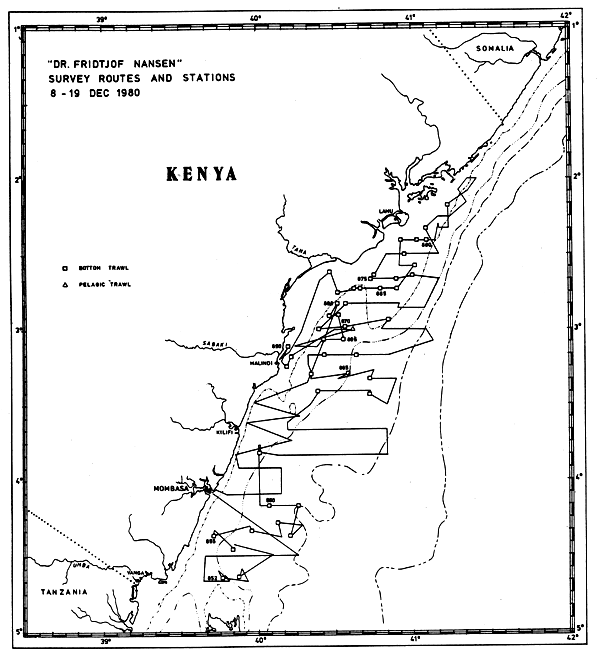
Fig. 2.1. Survey routes and stations during the first survey.
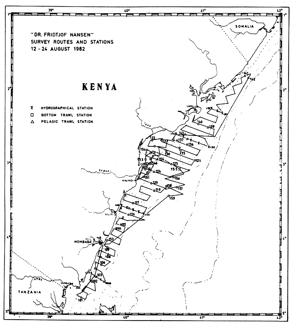
Fig. 2.2. Survey routes and stations during the second survey.
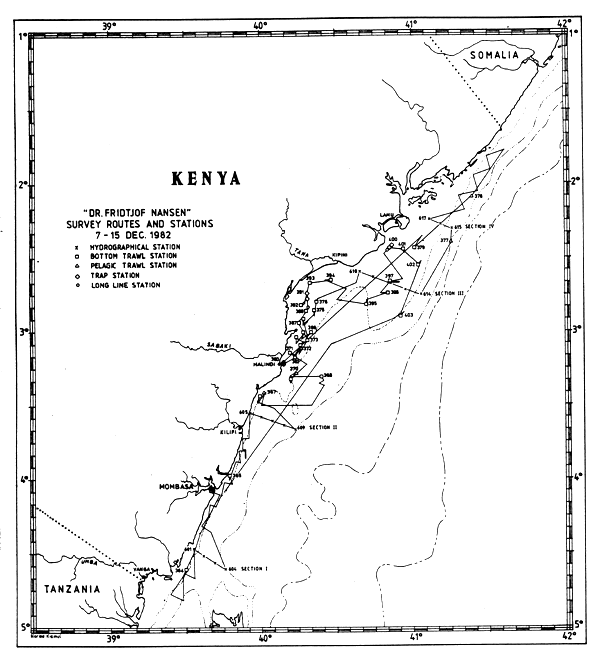
Fig. 2.3. Survey routes and stations during the third survey.
Fig. 2.4. Survey routes and stations during the fourth survey.
The R/V “Dr. Fridtjof Nansen” is equipped for acoustic investigations of fish abundance. The vessel has three scientific sounders (120, 50 and 38 kHz), one sonar and a net sonde (50 kHz). Two analog integrators are used for measuring the echo abundance; each of the integrators have two channels. One integrator was connected to the 38 kHz sounder with the channels operating in 4–50 m and 50–250 m varying with depths. The other integrator was connected to the 120 kHz sounder and the channels were operating in 4–50 m and 50–100 m varying with depth. Echo integrator values were read as mm deflection at each nautical mile and averaged over five nautical miles. These readings were scrutinized daily. Integrator values from false bottom, and others caused by non-biological targets were deleted. The integrator readings were divided into the categories plankton/fish-larvae, pelagic fish, mesopelagic fish and demersal fish. In the shallow areas pelagic and demersal fish were difficult to separate. Therefore they were combined into one category, fish.
The average values for fish readings over five miles were plotted in maps and isolines fitted by eye.
R/V “Dr. Fridtjof Nansen” carried out the surveys using a pelagic trawl (Capelin “Harstad”) and a demersal trawl (high opening fish and shrimp trawl). The specifications of the trawls are shown in Table 2.1. The pelagic trawl hauls were carried out either to identify scatterings layers or to investigate the surface layer for fish. The net sonde was used during the pelagic trawl hauls to control the operating depth of the trawl. The demersal trawl hauls were placed randomly in trawlable areas. Most of these localities were trawled on each survey. Trawling time was 30 minutes and the speed was about 3 knots. Based on this randomly chosen trawl stations, biomass estimations could be carried out according to the swept area method. The surveyed area was divided into different strata geographically and according the depth. The geographical areas are shown in Fig. 2.5. The three areas were North Kenya Bank (north of 3°S and east of 40°40'E), the Malindi-Ungama Bay area north of 4°S, and west of 40°40'E) and the southern area (south of 4°S). The depth intervals in the areas were chosen as less than 20 m, 20–50 m, 50–200 m, 200–500 m and deeper than 500 m. The average fish density based on the trawl catches were calculated for each of the strata. The fish density was obtained from the mean catch rate and the area swept by the trawl. This area equals the distance between the trawl wings (18.5 m) multiplied by the trawled distance. The efficiency of the trawl is an important parameter for converting the relative density to actual density per unit area. As little is known about this, the efficiency was set to one which means that all fish in front of the trawl were caught. By multiplying the density by the size of the stratum, the fish biomass can be estimated. The size of the areas of the different depth intervals was measured from the Admirality charts number 3361 and 3362.
Table 2.1. Specifications of the trawls.
| Demersal trawl: | High opening shrimp and fish trawl with rubber bobbins. |
| Headline 41 m. | |
| Height during trawling, about 6 m. Mesh size in the wings 40 mm, gradually reduced to 20 mm in the codend. | |
| Pelagic trawl: | Capelin (“Harstad”) trawl. |
| Width about 41 m. | |
| Vertical opening during trawling about 15 m. | |
| Mesh size in the codend 21 mm. |
Fig. 2.5. The investigated areas: 1) North Kenya Bank, 2) Malindi - Ungama Bay area, 3) The Southern area.
The largest area was covered during the first survey. The western border of the surveyed area was limited by depth less than 10 m. This western border was common for all the surveys (2.5).
The most important and abundant species in the trawl hauls were measured either to the nearest 0.5 cm or 1 cm depending on small or big fish.
Fig. 2.6. The collapsible fish trap.
In selected areas during the third and fourth survey a few tests with traps and longlines were carried out (Fig. 2.3. and 2.4.). The fish trap which is collapsible, consists of two frames, aluminium and iron (130 × 45 cm), floats and a net. The traps were usually used in chains of five. Fig. 2.6. shows a trap floating and thereby expanded due to the floats attached to the upper frame.
3. HYDROGRAPHY
The hydrographical data are presented as figures in Appendix. The thermocline was situated in depths between 50–150 m for all the surveys. The highest temperatures and salinities were observed during the third survey (December 1982).
The oxygen content was never below 3 ml/l in the upper 500 m and thereby had no limiting effect on the distribution of fish.
The hydrographical data have not yet been processed further.
4. FISH RESOURCES
4.1. Species composition and distribution
The species composition in demersal trawl catches at different depth intervals is shown in Table 4.1.
Table 4.1. Distribution in % of different biomass categories based on demersal trawl catches in different depth strata.
| Survey | 1 | 2 | 3 | 4 | ||||||||||||
| Depth | <20 | 20–50 | 50–200 | >200 | <20 | 20–50 | 50–200 | >200 | <20 | 20–50 | 50–200 | >200 | <20 | 20–50 | 50–200 | >200 |
| Category | ||||||||||||||||
| Leiognathidae | 30 | 71 | 3 | - | 41 | 37 | - | - | 2 | 20 | 3 | - | 12 | 39 | 5 | - |
| Pelagic fish | 25 | 2 | 24 | - | 22 | 15 | 2 | 1 | 45 | 52 | 40 | - | 24 | 32 | 21 | - |
| Dem. fish | 9 | 20 | 6 | 55 | 34 | 45 | 2 | 79 | 49 | 25 | 52 | 92 | 62 | 26 | 65 | 84 |
| Rays & Sharks | 28 | 7 | 4 | 21 | 1 | 3 | 77 | 17 | 4 | 3 | 5 | 8 | 1 | 2 | 7 | 10 |
| Crustacea | 7 | - | + | 23 | 2 | + | - | 1 | - | - | + | - | - | - | - | - |
| Squids | 1 | - | 1 | 1 | + | - | 1 | 2 | + | + | - | - | 1 | 1 | 2 | 6 |
| W(kg/hour) | 181 | 1564 | 77 | 46 | 213 | 496 | 190 | 141 | 85 | 890 | 117 | 104 | 173 | 173 | 687 | 68 |
| Number of hauls | 1 | 2 | 19 | 24 | 9 | 10 | 10 | 24 | 8 | 4 | 2 | 2 | 7 | 7 | 13 | 1 |
4.1.1. Leiognathidae
As seen from Table 4.1. the silver bellies are a very important group in shallow waters. As much as 71% of the average catch rate in the upper 50 m was Leiognathidae. The most important species were Leiognathus equulus, L. bindus, Secutor insidiator and Gazza minuta. They were especially abundant in the Malindi - Ungama Bay area. A trawl station in this area during the second survey gave about 1600 kg per hour. During the third survey the average total catch rate in the upper 50 m was reduced by about 50% compared to the other surveys. The main reason for this was an extremely low catch rate of Leiognathidae.
4.1.2. Pelagic fish
The main species in this group were rather small-sized fish. Pelagic fish were caught in waters shallower than 200 m, with the main catches in the depth region 10–50 m (Table 4.1.). The main families were Clupeidae, Carangidae, Scombridae and to some extent Sphyraenidae. Especially during the third and fourth survey, rather big quantities of the clupeids Pellona ditchela and Sardinella gibbosa were caught in the Malindi-Ungama Bay area. Except for 31 kg Decapterus sp. per hour at a trawl station east of Kilifi during the second survey, none of the 51 trawl hauls made in waters deeper than 200 m gave pelagic species.
During the four surveys, 13 pelagic trawl hauls were carried out at depths ranging from the sea surface to 390 m. The catches in these hauls were rather poor. In some of the surface hauls very small quantities of fish larvae were caught. The largest catches were taken during the second and last survey. During the second survey a pelagic trawl haul in the north-eastern part of Ungama Bay gave about 60 kg per hour of Sardinella longiceps and 40 kg per hour of Decapterus macrosoma. The haul was done in 85–100 m. A haul at 20 m depth northeast of Malindi during the last survey gave 20–44 kg per hour of the species Sardinella longiceps, Dussumieria acuta and Scomberoides commersonianus. About 100 kg per trawl-hour of sharks (Rhizoprionodn oligolinx were also caught. They were feeding on the anchovies and clupeids. In the northern area, north of Lamu a couple of trawl hauls resulted in small catches of myctophids (1-2 kg per hour).
4.1.3. Demersal fish
Demersal fish dominated the catches from deeper waters (Table 4.1). Rather good scattering layers recorded on the bottom in a small area at the southern part of North Kenya Bank during the last survey, turned out to be jobfish Pristipomoides filamentosus; 5.5 tonnes per hour. Their individual weights were 3.5–6.8 kg and lengths 72–85 cm. Other commercially important species caught in the 10–200 m zone were sicklefish (Drepane punctata, rock cods (Epinephelus spp) and various emperors (Lethiinidae). In depths beyond 200 m the dominating species were Chlorophthalmus agassizi, Zenion leptolepis, Peristedion spp and Antigonia rubescens.
4.1.4. Sharks and Rays
At maximum about 10% of the total catches were sharks and rays.
However, during the second survey 77% of the catches in the depth zone 50–200 m belonged to this group. This was due to twoo big catches of rays (Dasyatis spp), 1200 and 400 kg per hour. The hauls were made outside Malindi in Kilifi.
4.1.5. Crustacea and Squids
The catch rates of shrimps and prawns were very poor. Usually less than 1–2 kg per hour. However, during the first survey the average catch rate in waters deeper than 200 m was about 10 kg per hour, caused by a rather big catch giving 166 kg per hour northeast of Malindi.
The catches of squid were also very poor, on average less than 2 kg per hour.
4.2. Abundance of fish
The relative abundance of fish as mm deflection integrator readings is shown in Fig. 4.2.1 – 4.2.4 for the four surveys. The abundance of fish is rather poor. The highest concentrations were observed on the shelf in the Malindi-Ungama Bay and North Kenya Bank area. In deeper waters, the observations were extremely poor. The average integrator readings within each isoline were calculated. The area within the different isolines were estimated by counting squares of 0.5 × 0.5 cm drawn on a transparent paper placed upon the isoline map. The fish biomass could then be estimated according to the formula:
B = C · M · A
where C is the conversion coefficient, M the average integrator readings and A is the size of the area.
The performance of the acoustic equipment was the same during the second, third and fourth survey while different during the first one. According to Blindheim et al (1980) and Strømme et al (1981) and C-value to be used during the first survey is:
C = 0.2 · L
where L is the length of the fish in cm.
Due to the changing in performance, the C-value to be used for the three last surveys is:
C = 0.8 · L
Fig. 4.2.1. Distribution of fish as echo integrator recordings in mm per nautical mile during the first survey.
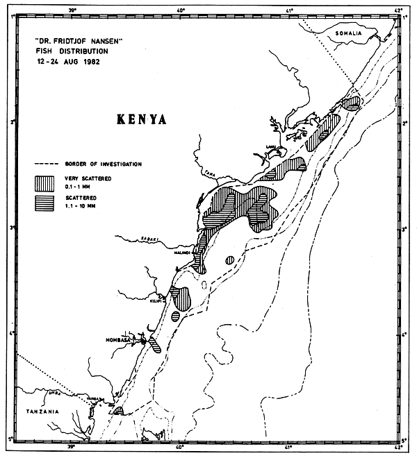
Fig. 4.2.2. Distribution of fish as echo integrator recordings in mm per nautical mile during the second survey.
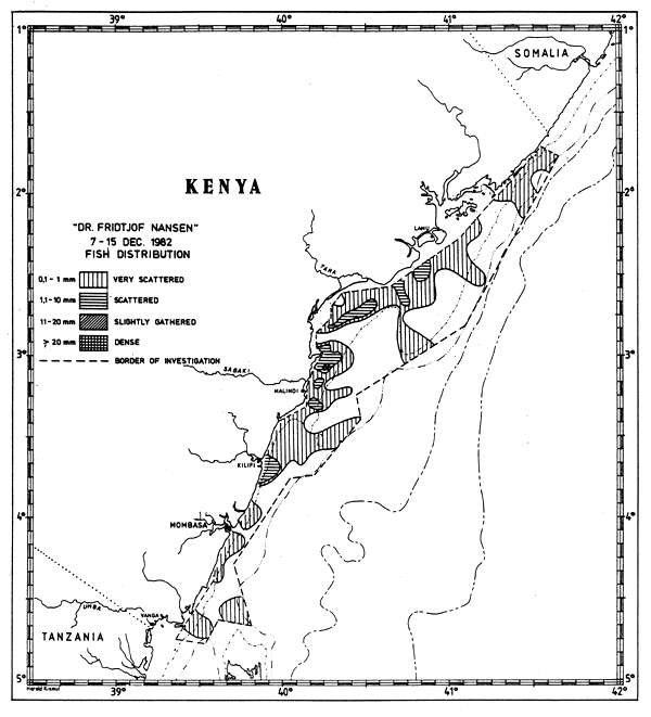
Fig. 4.2.3. Distribution of fish as echo integrator recordings in mm per nautical mile during the third survey.
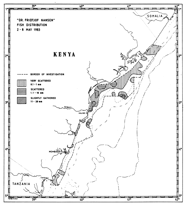
Fig. 4.2.4. Distribution of fish as echo integrator recordings in mm per nautical mile during the fourth survey.
According to the trawl catches most fish caught were small-sized. Based on the weighed modal length of the most important species, contributing more than 75% to the catches, the average length to be used in the formula for calculating fish biomass was about 16–18 cm. The calculations were carried out with 17 cm as a representative length for fish contributing to the acoustic index of abundance for the four surveys. The C-value for the first survey was then 3.4 tonnes/mm (n.mile)2 and for the other three surveys C = 13.6 tonnes/mm (n.mile)2. The estimated fish biomass based on these C-values are presented in Table 4.2.1.
Table 4.2.1. The estimated fish biomass based on the acoustic data for each of the four surveys.
| Survey No | 1 | 2 | 3 | 4 |
| 1000 tonnes | 22 | 29 | 32 | 18 |
The biomass observed by the acoustic equipment was similar in August and December 1982, while a decrease of about 40% was observed from December 1982 to May 1983. The biomass as shown in Table 4.2.1 is underestimated due to several factors. The vessel did not cover waters shallower than about 10 m. Fish resources living in this area were not included in the biomass estimates. As shown in Figs. 4.2.3 – 4.2.4 the two last surveys did not cover the registrations totally eastwards. Except for a couple of relatively dense patches in the last survey (Fig. 4.2.4) the registrations in the eastern area were of the category “very scattered”. Therefore the biomass is probably not severely underestimated due to lack of eastern coverage. The biomass is underestimated due to other factors as well. Fish close to the sea surface and to the bottom are not observed by the acoustic equipment. The few trawl hauls taken in the surface layer indicated that very small quantities if anything at all were lost due to this limitation of the equipment. Fish close to the bottom is not detected by the sounder. The thickness of this “dead-zone” depends on the depth and the bottom configuration. Investigations in other areas have demonstrated that noise of the research vessel could scare fish away (Olsen et al, 1982). This may also to some degree cause an underestimate in the acoustic abundance. However, the fish biomass according to these investigations is rather low. In 1982-1983 the fish biomass outside Tanzania was estimated by the same technique and equipment to be in the order of 100 000 - 200 000 tonnes (Iversen et al 1984). In Tanzania and in Kenya the fish were usually observed in waters shallower than 200 m. The fish biomass according to the acoustic investigations are 5 to 6 times higher in Tanzanian than in Kenyan waters.
The inshore waters were not investigated during the four surveys. If the fish abundance in these waters is similar to the abundance observed in the western border of the investigated area, an estimate of the fish biomass in the inshore waters could be carried out. The acoustic estimates should then be increased by about 30% and 40% for the two first surveys, about 70% for the third and about 50% for the last survey. According to this the biomass in the inshore waters and in the surveyed area is in the order of 30 000 – 50 000 tonnes for the four surveys.
The size of the strata for estimating fish biomass by the swept area method are shown in Table 4.2.2.
Table 4.2.2. The area of the different strata in square nautical miles.
| Depth interval (m) | <20 m | 20–50 m | 50–200 m | 200–500 m | >500 m |
| Area | |||||
| North Kenya Bank | 5 | 75 | 905 | 415 | 270 |
| Malindi-Ungama Bay | 235 | 125 | 210 | 925 | 375 |
| Southern area | 5 | 15 | 130 | 1200 | 1950 |
The average catch rates and number of trawl hauls for the different strata are shown in Table 4.2.3. In the southern area only two trawl stations were carried out during the two last surveys. This is too few to estimate the biomass. However, the catch rates obtained during the third and fourth survey for this area are within the range obtained during the first and second survey when 10 and 6 stations were made respectively. The estimate concerning North Kenya Bank during the fourth survey has been carried out without trawl station 432 (Fig. 2.4) because this was aimed trawling on rather high fish concentrations observed by the sounder (Chapter 4.1.3). The estimates for standing stock obtained this way, shown in Table 4.2.4 were similar for each of the four surveys. The estimates varied between 14 000 and 16 000 tonnes. The acoustic estimates are about 1.5 – 2 times higher than these estimates. This indicates an efficiency of the trawl being 0.5–0.7. However, the acoustic estimates include registrations above the area swept by the trawl. The opening of the demersal trawl is about 6 m. On the other hand the acoustic estimate exclude fish close to the bottom. This fish are probably included in the swept area estimates.
Table 4.2.3. Average catch rates (W=kg/hour) and numbers (N) of demersal trawl hauls for the four surveys in each strata. (Exclusive rays and sharks).
| Survey | 1 | 2 | 3 | 4 | |||||||||||||||||
| Depth (m) Area | <20 | 20–50 | 50–200 | 200–500 | >500 | <20 | 20–50 | 50–200 | 200–500 | >500 | <20 | 20–50 | 50–200 | 200–500 | >500 | <20 | 20–50 | 50–200 | 200–500 | >500 | |
| North Kenya Bank | W | - | - | 69 | - | 5 | - | - | 36 | 39 | - | 4 | - | 37 | - | - | - | - | 855x) | - | - |
| N | - | - | 13 | - | 2 | - | - | 7 | 2 | - | 1 | - | 7 | - | - | - | - | 9 | - | - | |
| Malindi-Ungama Bay | W | 184 | 1564 | 155 | 88 | 15 | 210 | 483 | 41 | 41 | 13 | 99 | 859 | 232 | 96 | - | 171 | 720 | 219 | - | - |
| N | 1 | 2 | 3 | 11 | 1 | 9 | 10 | 1 | 7 | 2 | 6 | 4 | 5 | 1 | - | 7 | 7 | 3 | - | - | |
| Southern area | W | - | - | 32 | 14 | - | - | - | 99 | 175 | - | 51 | - | 35 | 100 | - | - | - | 20 | 61 | - |
| N | - | - | 3 | 7 | - | - | - | 2 | 14 | - | 1 | - | 1 | 1 | - | - | - | 1 | 1 | - | |
x) Inclusive trawl station 432. Exclusive this station: 248 kg/hr.
The reduction in biomass of about 40% as observed in the acoustic estimates from August-December 1982 to May 1983 were not reflected in the estimates based on the swept area method. This indicates that the biomass close to the bottom was rather constant during the investigated period. The same investigations in Tanzania were carried out just before or after each of the three last Kenyan surveys (Iversen et al., 1984). These investigations resulted in a similar relationship between biomass estimates based on acoustic data and the swept area method. A similar relationship was also obtained from results of surveys outside Mozambique (Sætre et al., 1979).
The target strength of sharks and rays is rather low. Therefore, for comparison with the acoustic biomass estimate, they were excluded in the biomass estimate based on the swept area method. The biomass of the elasmobranchs estimated by this method was 2000; 6000; 1000 and 2000 tonnes respectively for each of the four surveys. The large biomass estimated for the second survey was mainly due to two big catches of rays outside Malindi and Kilifi (Chapter 4.1.4).
4.3. Experiments with fish traps and long-lines
During the third and fourth survey some trap and longline stations were made. The locations of the stations are shown in Figs. 2.3. and 2.4. The catch rates for the traps varied between 1 and 40 kg per 5 traps per night. The traps were placed in areas with rough bottom, not suitable for trawling. Big fish such as Ephinephelus spp, 6–10 kg, and Lutjanus spp, 2–7 kg were caught at North Kenya Bank. The experiments with traps indicated that placed in proper areas they fish very well. Squids and small fish were tried as bait, but no difference in catch between the two types of bait were observed.
Two longline stations were carried out during the third survey (Fig. 2.3). The lines had 70 hooks and were in the sea for one hour. During that time most of the bait (squids) disappeared. At the line station in Ungama Bay nothing was caught, while two sharks (Carcharhinus sealei) of about 4 kg each were caught at North Kenya Bank.
Table 4.2.4. The fish biomass estimates in 1000 tonnes for each of the four surveys based on the swept area method.
| Survey | 1 | 2 | 3 | 4 |
| Area | ||||
| North Kenya Bank | 2.1 | 1.6 | 1.1 | 7.5 |
| Malindi/Ungama Bay | 11.9 | 5.4 | 9.0 | 5.8 |
| Southern area | 0.7 | 7.4 | 4.5 | 2.7 |
| Total | 14.7 | 14.4 | 14.6 | 16.0 |
5. CONCLUSION
The size of the biomass in the investigated area is about 20 000 – 30 000 tonnes. The fishery takes place in the inshore area which is not covered by the investigations. The potential yield (y) from the investigated area could be estimated according to Gulland's formula:
Y = 0.5 · M · B0
where M is the natural mortality and BO the biomass. In FAO(1979) 0.5 is suggested as an overall value for natural mortality for similar species compositions as observed during the “Dr. Fridtjof Nansen” surveys. The potential yield was estimated of 5000–7500 tonnes. The size of the potential yield depends on the chosen value for natural mortality. If the natural mortality is closer to 1 than 0.5 the potential yield is increased by 100%. Big fish as snappers and rock cods have low natural mortality and thereby these stocks could only support a low fishery. Species with higher natural mortality could support a relatively higher fishery. It is possible that larger species in general will decline faster than smaller species because the different species will not react the same way to fishery pressure.
In the inshore area the annual catch is about 5000 tonnes. By extending the fishing area beyond the reef it seems that the yield at least may be increased by 100%. However, the fish density in this area is rather low therefore it may be difficult to fish the potential yield. A main part of such a fishery would be silverbellies.
6. REFERENCES
ANON. 1981. Report on cruise with R/V “Dr. Fridtjof Nansen” off Kenya 8–19 December 1980. Reports on Surveys with the R/V “Dr. Fridtjof Nansen”, Institute of Marine Research, Bergen.
ANON. 1982a. Survey of the abundance and distribution of the fish resources off Kenya 12–24 August 1982. Reports on Surveys with the R/V “Dr. Fridtjof Nansen”, Institute of Marine Research, Bergen.
ANON. 1982b. Survey of the abundance and distribution of fish resources off Kenya 7–15 December 1982. Reports on Surveys with the R/V “Dr. Fridtjof Nansen”, Institute of Marine Research, Bergen.
ANON. 1983. Survey of the abundance and distribution of fish resources off Kenya 2–8 May 1983. Reports on Surveys with the R/V “Dr. Fridtjof Nansen”, Institute of Marine Research, Bergen.
BLINDHEIM, J., DE BRUIN, G.H.P. and SÆTERSDAL, G. 1979. A survey of the coastal fish resources of Sri Lanka. Report no. II, April-June 1979. Reports on surveys with R/V “Dr. Fridtjof Nansen”. Fisheries Research Station, Colombo, Institute of Marine Research, Bergen.
FAO, 1979. Report on the FAO/IOP Workshop on the Fisheries Resources of the Western Indian Ocean South of Equator (ed. J. Gulland). IOFC/DEV/79/45 FAO, Rome.
IVERSEN, S.A., MYKLEVOLL, S., LWIZA, K. and YONAZI, J. 1984. Tanzanian marine fish resources in the depth region 10–500 m investigated by R/V “Dr. Fridtjof Nansen”. Joint Tanzanian/ Norwegian Seminar, Mbegani, Tanzania 6–8 MARCH 1984.
OLSEN, K., ANGELL, J. PETTERSEN, F. and LøVIK, A. 1982. Observed fish reactions to a surveying vessel with special reference to herring, cod, capelin and polar cod. Symp. on fish. Acoust. Bergen, Norway 21–24 June 1982. No. 48. [Mimeo].
STRøMME, T., NAKKEN, O. and SÆTERSDAL, G. 1981. Surveys of the marine fish resources of Burma, Sep-Nov 1979 and May-Apr 1980. Reports on Surveys with the R/V “Dr. Fridtjof Nansen”, Institute of Marine Research, Bergen.
SÆTRE, R. and PAULA E. SILVA, R. 1979. The marine fish resources of Mozambique. Reports on surveys with the R/V “Dr. Fridtjof Nansen”, Institute of Marine Research, Bergen.
APPENDIX
The hydrographical sections of the three last surveys.
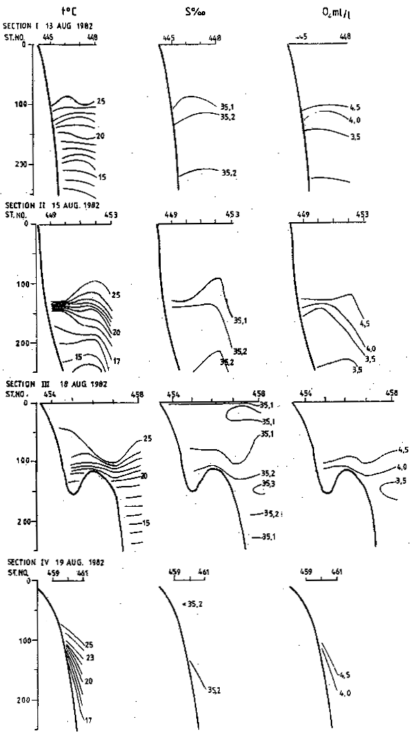
Fig. 1. Temperature, salinity and oxygen content at sections I-IV during the second survey.
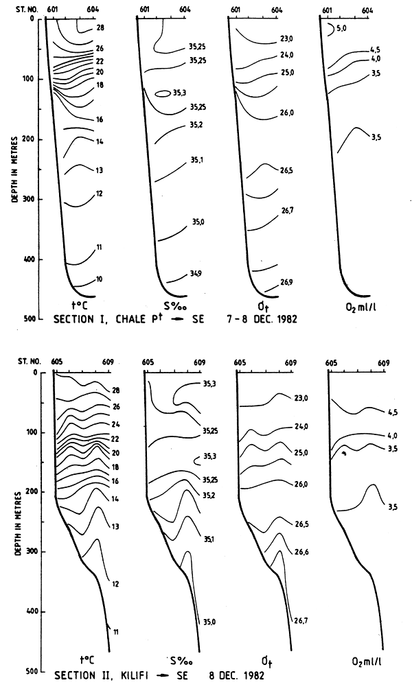
Fig. 2. Temperature, salinity, density and oxygen content at Sections I and II during the third survey.
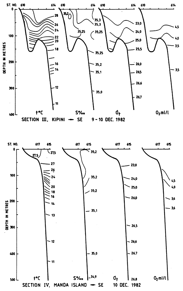
Fig. 3. Temperature, salinity, density and oxygen content at Sections III and IV during the third survey.
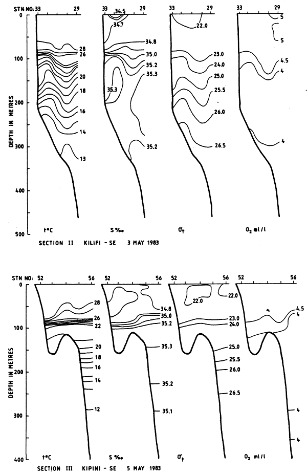
Fig. 4. Temperature, salinity, density and oxygen content at Sections II and III during the fourth survey.
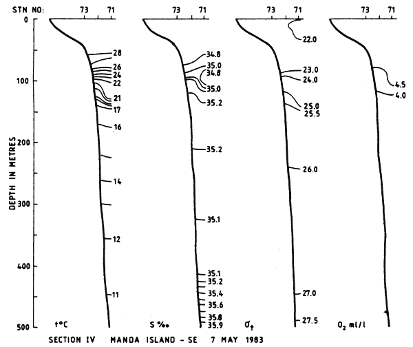
Fig. 5. Temperature, salinity, density and oxygen content at Section IV during the fourth survey.
by
Siebren C. Venema
Food and Agriculture Organization
FAO, Rome
1. INTRODUCTION
A number of resource surveys have been executed in Kenyan waters mainly through FAO projects. Bottom trawl surveys in inshore waters were executed in the sixties with the Kenyan research vessel SHAKWE and with commercial trawlers, while an extensive bottom trawl survey of deeper waters was executed with FAO's vessel UJUZI in 1979-81, assisted for the deeper areas by the DR. FRIDTJOF NANSEN in December 1980. Acoustic and trawl surveys were made in the period 1975-76 by the R/V DR. FRIDTJOF NANSEN and in 1976-77 by the R/V PROF. MESYATSEV. The North Kenya Bank was visited with hook and line gear by the R/V MANIHINE and also by the UJUZI. Huge beam trawls were introduced by the commercial trawler KUSI assisted by a Dutch project. The creeks and inlets were submitted to a detailed inspection by the SHAKWE assisted by an Icelandic bilateral project around 1980.
Assessments based on data collected from commercial and/or artisanal fisheries are not available, therefore most of the figures on fisheries potential for Kenya are based on educated guesses and comparisons with similar areas. This practice was followed in the FAO/IOP Workshop on the Fishery Resources of the Western Indian Ocean, South of the Equator, held in Mahe, Seychelles, from 23 October-4 November 1978, after completion of the survey programme of the PROF. MESYATSEV.
In August 1982 the DR. FRIDTJOF NANSEN returned for a full coverage of Kenyan waters with acoustic instruments and bottom trawls. This survey was repeated twice in December 1982 and May 1983.
Kenya's marine resources can be divided into 10 main groups. These groups differ in biotope and behaviour and therefore require different methods for survey and catching, as indicated in Table 1.
Group 1, the large pelagic fish, an oceanic resource, has been surveyed in Kenya (see FAO, 1969 and Williams, 1956) and has been exploited by the two Kenyan longliners in recent years, as well as by game fishermen.
Group 2 form the main topic of the DR. FRIDTJOF NANSEN surveys, which also include small demersal fish, as far as these become accessible to acoustic assessments, e.g. at night and in waters deeper than 20 m. This group was also covered by the PROF. MESYATSEV.
Group 3 can best be assed by a systematic trawl survey with small meshed trawls. This kind of survey has been carried out with the R/V UJUZI in recent years, but published reports are not available.
Penaeid shrimp stocks (Group 4a) were surveyed in the bays and creeks during the first FAO projects in the sixties. Systematic surveys of these resources have not been done in recent years, while data of the commercial fisheries are also lacking. Deep-sea shrimp (Group 4b) were surveyed with the R/V's PROF. MESYATSEV and UJUZI.
Group 5, large demersal fish, has been surveyed mainly on the North Kenya Banks, using hook and line gear, traps and trawls, by the R/V's MANIHINE, UJUZI and DR. FRIDTJOF NANSEN.
Of the lobsters (Group 6), the spiny lobsters were systematically surveyed by Brusher and Barker (FAO, 1969 and 1971) while the deep-sea lobster resources were systematically surveyed with the UJUZI, after having been discovered by PROF. MESYATSEV.
No records are available of systematic surveys on groups 7 to 10 (molluscs, seaweeds and bêche de mer).
Of the various biotopes along the Kenyan coast, very little data is available on the resource of the reefs, the mangroves and related creeks, all of which areas are under heavy exploitation by artisanal fishermen.
Resource surveys can be divided into two main categories:
Systematic, random surveys to obtain a biomass estimate of one or more of the above groups;
Exploratory surveys, a fisherman's approach trying out various types of gear on different grounds. Larger vessels would be fishing mainly on the basis of indications on the echosounder.
A third category of data is formed by trawl hauls made during an acoustic survey to identify traces on the echosounder and to sample for size and species composition. These data cannot be considered part of a random trawl survey pattern as indicated under i).
2. SURVEYS WITH THE R/V PROF. MESYATSEV AND FAO/IOP WORKSHOP
The results of the surveys with this vessel from the USSR contracted by the Indian Ocean Programme are given in a number of reports Birkett (1978), VNIRO (1978) and FAO/IOP (1979). Surveys (acoustic and trawl) were carried out in the following periods: 18–23 December 1975, 3–4 January 1976, 10–17 March 1976, 11–18 June 1976, 1–8 July 1977 and 24–29 November 1977.
2.1 Trawl surveys
A total of 127 hauls were made in the above-mentioned periods, 66.4 m.t. of fish and crustaceans were cauight along a towed track of 581.5 n.mi. The gear used was the Treska M trawl (Fig. 1) with a codend mesh size of 100 mm, a headline length of 32 m and a vertical opening of 6 m1. For crustaceans a lobster trawl was used (headline 55 m, vertical opening 4 m and a codend mesh size of 100 mm) (Fig. 2).
Three different grounds were surveyed, all north of Malindi (see Figs. 3a and b). (A small area north of Pemba Island was considered to come under Tanzania). The main results of the trawl hauls are presented in Table 2 by area.
Very few hauls were made on the North Kenyan Banks: 4 in December 1975, 3 in March 1976, 3 in June 1976 and none in 1977. Most of the effort was concentrated in the same areas where later also the R/V UJUZI would expend most of its effort. This was due to the very special conditions posed by bottom configuration and the very strong currents. The PROF. MESYATSEV discovered the grounds of the deep-sea lobster (Puerulus sp.), which were later explored in detail by the R/V UJUZI.
2.2 FAO/IOP Workshop
The results of the trawl surveys of the PROF. MESYATSEV were analysed and combined with other data on non-trawlable areas at the FAO/IOP Workshop in 1978.
The trawl surveys provided three averages for densities of demersal fish in the Ungwama Bay area and north of Pemba of respectively 2.5, 0.85 and 1.65 t/km2 (see Table 3). Yields in the non-trawlable areas were taken as 0.5 t/km2 in all cases1. The densities were converted into potential yield estimates through the formula Potx) yield = 0.5 M × Bo, where M is the natural mortality coefficient and Bo the unfished biomass.
The results of this exercise are presented in Table 3. The overall yield of 9 790 tons from an areas of 20 500 km2 gives the very low figure of yield per km2 of 0.48 tons, or 4.8 kg/ha. It should be said that this approach is very rough indeed and that the coastal areas and the North Kenya Bank in particular should have been treated differently. If the large mesh size was used the catch of small species will have been low, and then the biomass density of this group has been underestimated. Nevertheless, these results indicate that a large trawler like the PROF. MESYATSEV did not find much to fish outside three small areas.
2.3 Acoustic surveys
The acoustic surveys carried out by the PROF. MESYATSEV mainly covered the trawlable areas and because of this they were not a fully independent method of resource assessment. The methodology followed for converting the reading of the echointegrator into biomass figures underlines this. The conversion factor was obtained namely by integrating a layer of 6 m high from the bottom, and trawling at the same time. The method is described in detail by Burczynski (1976) (Fig. 4). Very little use has been made of these data, which have now been superseded by the more reliable FRIDTJOF NANSEN data. The total biomass of pelagics in the area surveyed was estimated at 18 360 tons in March 1976 and only 6 600 t in November 1977. This biomass consisted mainly of scads and mackerels. The FAO/IOP Workshop came to a rough estimate of potential of 10 000 tonnes.
3. “OFFSHORE TRAWLING SURVEY” WITH THE R/V UJUZI
Under an FAO/UNDP project (KEN/74/023), the R/V UJUZI was used to survey the offshore Kenyan waters from February 1977 until June 1981.
1 In Tanzania several reef areas were estimated to yield 5 t/km2 per year, or ten times as much.
The vessel UJUZI (much smaller than the PROF. MESYATSEV and DR. FRIDTJOF NANSEN) was equipped with a high opening fish-cum-shrimp trawl, lobster trawl, bottom trawl and, for short periods, also with a beam trawl and electric reels. In addition to detailed sampling of the catch carried out mainly by scientists supplied by the Kenya Marine and Fisheries Research Institute (KMFRI), the skipper recorded details on wind and sea state and, in particular, on force and direction of the current. The intention was to design a stratified random sampling scheme on the basis of preliminary survey data, but it never came to such a plan due to the difficulties encountered in fishing in a given place at a given time, in particular during May to August. Instead the data obtained in periods and in places where fishing was possible were analysed using post stratification. In general, the fishable areas were exactly the same as those identified by the PROF. MESYATSEV.
A number of work reports and a final report were issued. Work Report No. 8 contains the stock assessment data. This Work Report has also been used for a case study on a trawl survey during the FAO/DANIDA Training Course in Fish Stock Assessment. The conclusion of that case study was that the work done was nearly as good as was possible under the circumstances, and that the accuracy of the estimates was sufficient for planning purposes. The project document adhered strictly to the offshore waters, consequently the shrimp grounds in Ungwama Bay and the smaller creeks were not surveyed, which was a pity since a full coverage might have given a more complete insight into the biology of some important species. On the other hand, such data are obtained from commercial fisheries and the surveys with the R/V SHAKWE. Since it was not possible to cover the waters from 300 m up to a depth of 800 m, as indicated in the project document, the DR. FRIDTJOF NANSEN was assigned the task of covering the very deep waters (December 1980). A systematic grid of trawl stations was designed, but these deep waters turned out to be mainly untrawlable and where hauls were made the catch consisted of very rare species, exciting for the taxonomist aboard but no thrill for a fishery development planner1..
The project therefore clearly determined the offshore limits to trawling in Kenyan waters. Also the commercial efforts of the M/V KUSI in the same period underline these findings. The deep-sea lobster grounds were further analysed and a clear picture has been obtained of the extent and yield from these grounds.
Table 4 taken from the final report of the project gives a summary of the findings. A simple feasibility study incorporated in Work Report No. 8 indicates that offshore trawling in Kenya is generally not a profitable undertaking.
A small comparative fishing exercise btween R/Vs UJUZI and the DR. FRIDTJOF NANSEN was “won” by UJUZI, an indication that the high opening fish-cum-shrimp trawl used was an optimal gear. The existing fleet could make use of this gear design and perhaps also tap the deep sea lobster grounds occasionally.
The North Kenya Bank was to quite an extent trawlable on the west side; however, a large part of these grounds were covered by large sponges and the large spiculae of the sponges damaged the fish to such an extent that harvesting this resource commercially by means of a trawl can be ruled out.
The total area covered by the UJUZI, taken from the 10 fathom line to about 400 m depth, was estimated to be 12 675 km 2, of which more than 10 000 km2 were considered to be trawlable (Work Report No. 8). Comparing this with the results of the PROF. MESYATSEV and DR. FRIDTJOF NANSEN, it seems that the extent of the trawlable area may have been overestimated.
The total biomass (standing stock) in the trawlable area was estimated to be 32 100 m.t. of which about 25% were sharks and rays, 30% were small non-commercial fishes, 12% large commercial fish, and 10% crustaceans of which 3% were lobsters. The maximum sustainable yield from this resource was taken as 9 033 m.t. of which 3 945 t should be considered non-commercial species, leaving 529 t for big commercial fish, 500 t for lobster and 755 t for deep-water shrimp. These figures may seem interesting as total possible yield figures, but for commercial exploitation the catchrates and seasonality are of utmost importance. From the calculations made it would seem that only the exploitation of the small lobster ground would be economical; however, the seasonality of the fishery in this area has been clearly demonstrated and therefore a year-round fishery on this resource may not be feasible.
![]()
![]()
![]()