![]()
![]()
![]()
P.M. Porter, H.L. Porter and A.D. RafleBonka Research Station Bay Region Agricultural Development Project
PO Box 2971, Mogadishu, Somalia
Abstract
Introduction
Crop production
Livestock production
Discussion
Acknowledgments
References
Vertisols occupy less than 20% of the Bay Region of Somalia, yet virtually all the crop production in the region occurs on these soils. The other soils of the region are suitable for rangeland. The combination of soil types supports an established, stable and well-adapted agropastoral system that integrates livestock and crop activities. Constraints to the system include unreliable rainfall, household labour shortages, and low soil fertility.
The Bay Region is located between the Juba and Shebelle rivers in south-central Somalia (Figure 1). Due to the relatively good climate and soils, it is considered to have the greatest potential in Somalia to intensify and expand dryland agriculture (USAID, 1980). The area has more livestock than any other region in Somalia (HTS, 1982). Rainfed farming has coexisted with pastoralism in an agropastoral economic system that has evolved over the centuries. The majority of the rural population are agropastoralists (Putman, 1985). Crop production and livestock rearing are integrated within nearly every household to secure subsistence (HTS, 1983).
Figure 1. Map of Bay Region in Somalia, and Vertisols area in Bay Region (inset).

Source: HTS (1983)
With an area of 4 million ha and a population in 1982 of approximately 440 000, the Bay Region had a population density of 11 km-2. The total livestock population was roughly 2.5 times the human population (HTS, 1982). Livestock numbers are greatly reduced in times of drought.
The climate of the Bay Region follows a bimodal rainfall pattern. The light rainy season (Dayr) usually begin by mid-October, and the heavy rainy season (Gu) usually begins by mid-April (Figure 2). Both rainy seasons last only 3-6 weeks and are extremely variable and unpredictable. Crops can be expected to fail 3 out of 10 years in the heavy rainy season and even more frequently during the light one (Schmidt, 1981).
The region has no natural perennial surface water. Lack of reliable water supplies is a major constraint to increasing livestock and crop production (HTS, 1983).
Based on soils, vegetation and geology, the Bay Region has been subdivided into five major geomorphological-ecological units: basement complex peneplain, limestone plateau, basement complex-limestone interface, coastal plain deposits, and clay plains (HTS, 1982). The topography of much of the region, which is at 100-500 m altitude, is flat to gently rolling.
About 18% of the Bay Region is occupied by the clay plains. These are Vertisols (Figure 1) on which the majority of crops are grown. Aerial surveys in 1982 determined that 11% of the Bay Region was cropped land and associated fallow. The remaining area was suitable only as rangeland (HTS, 1982).
Figure 2. Climatic conditions at Bonka Research Station in the Bay Region of Somalia.
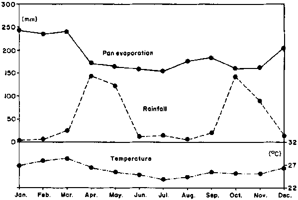
Mean annual rainfall = 590 ± 210 mm
Mean annual evaporation = 2250 mm
Mean annual temperature = 26.2°C
Mean annual maximum temperature = 32.1°C
Mean annual minimum temperature = 19.8°CSources: HTS (1982); HTS (1983).
The major soils surrounding, and also spotted throughout, the cultivated Vertisols area are Regosols. Because these soils are better drained and less sticky when wet than the Vertisols, villages are frequently located on the Regosols, adjacent to the Vertisols. This allows the agropastoralists to have immediate access to land for both cultivation and livestock.
The Vertisols have characteristics (Table 1) similar to other Vertisols found in East Africa (Berhanu Debele, 1985; Muchena and Gachene, 1985.)
Table 1. Physical and chemical characteristics of the major Vertisols in the Bay Region of Somalia.
|
|
Soil type designation |
||||
|
Amin |
Baidoa |
Bur Acaba |
Uiamo |
Mode Mode |
|
|
Total area (ha) |
100 000 |
133 000 |
192 000 |
273 000 |
43 000 |
|
Cropped area(%) |
30 |
72 |
52 |
42 |
52 |
|
Surface horizon characteristics |
|||||
|
Colour |
red-brown |
dark brown |
brown |
grey |
grey |
|
|
5YR 4/3 |
10YR 4/3 |
7.5YR 4/2 |
10YR 5/2 |
10YR 5/2 |
|
Texture |
clay |
clay |
clay |
clay |
clay |
|
pH |
8.0 |
8.1 |
8.0 |
8.4 |
8.1 |
|
Organic matter (%) |
1.7 |
1.2 |
1.4 |
1.8 |
1.3 |
|
CEC (meq/100 g) |
50 |
70 |
40 |
50 |
55 |
|
Available P |
low |
low |
low |
low |
low |
|
Available K |
high |
high |
high |
high |
high |
Sources: HTS (1982); FAO (1968); Newton, (1968).
The clay minerals are the montmorillonitic type. Deep, wide cracks are common during the dry seasons. In some areas a gilgai microrelief is present, but not well expressed. Slickensides are present in subsurface horizons of most profiles.
The soils are calcareous, especially in the subsurface horizon where calcium carbonate is irregularly distributed as soft powdery lime or calcium carbonate concretions or nodules.
The cation exchange capacity of these soils ranges from 40 to 70 meq/100 g of soil. The predominant exchangeable cation, which accounts for up to 80% of the exchange complex, is Ca followed by Mg. Na and K contribute nearly equal proportions in the surface horizon of most profiles. The contribution of other cations in the exchange complex is negligible. Salinity and Na hazards are low to nil in the surface horizon, and low to moderate in the subsurface horizon (HTS, 1982). The organic matter content is less than 2% in the surface horizon, decreasing to about 1% at 1 m. These soils are high in available K and very low in available P (Newton, 1968; Strong, 1986). Experiments conducted at the Bonka Research Station on the Baidoa soils have shown a doubling of both sorghum and mungbean grain yields with the proper application of triple superphosphate. Goat and cattle manures gave similar results (Buker, 1986).
Sorghum is by far the major crop grown in the Bay Region. It is grown in both cropping seasons on over 90% of the cultivated land (HTS, 1983). Although there have been attempts to introduce new sorghum lines, the local variety remains dominant throughout the region. Sorghum, along with animal products, such as meat, milk and ghee, comprises the staple diet of the region. Occasionally cowpea and mungbean are interplanted with the sorghum. Other crops of minor importance include maize, sesame and peanuts.
Most farmers produce subsistence crops by traditional methods on small cultivated areas, with low inputs and low yields. The most common agricultural implement is the yambo, a hoe with either a short or long handle. It is used to plant and cultivate. The average area of cultivated land per household unit has been estimated at 1-8 ha. Grain yield per hectare is variable, depending primarily on the amount and distribution of rainfall: estimates generally range from 300 to 1000 kg ha-1 in seasons of adequate rainfall (University of Wyoming, 1984; Putman, 1985; Watson and Nimmo, 1985).
Seldom is all of the farmland owned by a single household farmed each season. In addition to the major constraint of labour shortages, and the calculation of an inadequate return, land left idle provides grazing for livestock, which is recognised as a way to control weeds as well as to increase soil productivity (University of Wyoming, 1984).
Most of the sorghum is consumed by the household unit which produces it. Only small amounts are marketed as needs arise. Some people with large farms may market relatively large amounts of sorghum when conditions are favourable, but this is the exception rather than the rule (University of Wyoming, 1984; Watson and Nimmo, 1985).
There have been numerous attempts over the past 30 years to introduce animal traction into the Bay Region, yet today very few farmers incorporate animal traction in their farming system. According to Martin (1986) the major constraint to the use of animal traction is drought and its effect on the availability of forage and water: the second most important constraint is inadequate and broken implements.
In February 1982 there were approximately 320 000 camels, 370 000 cattle, 360 000 goats, and 40 000 sheep in the Bay Region (HTS, 1982). The camels are single-humped dromedaries and the cattle are mainly of the East African short-horn Zebu type. Two types of goats are found in the region-the short-earned East African type, White and Southern Somali (the more common type) and the Arbed, "Arab Goat". The sheep are essentially all the Somali Blackhead type.
Between 1975 and 1982 the numbers of camels and sheep appeared to decline, while the numbers of cattle and goats increased in the region. This may indicate an increasing trend towards a more sedentary way of life in the Bay Region (HTS, 1982).
Livestock are kept for subsistence food production and to generate cash to purchase other foods, clothes and consumer goods. Livestock provide the means for capital accumulation during favourable periods and security for stock owners to survive droughts by the consumption and sale of animals. In addition to food, security and investment, livestock (especially camels) also offer prestige. Putman (1985) states that most agropastoralists would rank livestock higher as an investment item than agricultural implements.
A number of livestock management systems are employed depending on family labour availability, location, herd sizes and livestock types. Watson and Nimmo (1985) describe 10 livestock production strategies, varying from settled agropastoralism to nomadic pastoralism, used by the inhabitants of the region. Keeping mixed species herds is common. It is favoured because a range of environments can be exploited, a range of products can be produced, species have different survival and recovery rates after droughts, and family labour availability can be best exploited (Hendy, 1985).
The major influences on the distribution of livestock within the region are water and forage. Livestock concentrate at the more reliable or permanent water sources as the dry season progresses. Vertisols, due to their good water retention properties, support the majority of these water sources. These soils also have a greater forage potential and a longer growing period than the other soils of the region (HTS, 1982; Watson and Nimmo, 1985).
The availability of forage is dependent on rainfall and soil type, and is influenced by the species of livestock and the supply of crop residues. In normal years livestock move onto cropland during and following harvest, where they feed on sorghum stover, on limited rangeland between sorghum fields, and on weeds on fallowed land. If a growing season is poor, livestock are brought back to the cropland earlier to graze on the growing sorghum (Watson and Nimmo, 1985).
The availability of sorghum stover is a major factor in maintaining livestock numbers and in influencing management systems. Sorghum crop residues may supply as much as 25-33% of the mean annual total of the forage produced in the region (HTS, 1982). Watson and Nimmo (1985) state that the value of these residues during the dry seasons cannot be overestimated and they suggest that sorghum should be regarded as a fodder crop which occasionally produces grain.
Typically the stover is grazed in the field once the heads have been harvested. Less often the stover is removed from the field and either fed directly to penned livestock near the homes or stored for later use. Although rangeland is regarded as communal and cropland as private, sorghum stover left after the initial grazing is generally considered common property.
Sorghum stover is a good source of roughage, but is low in digestible crude protein. The mineral status of the natural diet of the livestock in the region is unknown. Typical P deficiency symptoms of pica and excessive hoof growth have been observed (HTS, 1982).
According to Watson and Nimmo (1985), between 1973 and 1983 the area of cropped Vertisols in the Bay Region expanded at about 3% per year, a rate similar to the rate of expansion of the human population. They suggest that the expansion of cropped land is actually a reduction of the period that land is fallowed, and that this may lead to a long-term reduction in fertility and change soil characteristics of the Vertisols which are under intensive and continuous sorghum cropping.
Efforts to improve livestock and crop production in the Bay Region must reflect the interdependence of the two. In order to improve the well-being of the inhabitants of the region, development projects should take a holistic approach to problem solving. In this manner, unforeseen imbalances between livestock and crop production will be minimised.
The authors are grateful for the support of M.W. Duale, General Manager, and Dr R.J. Buker, Director of Research, Bay Region Agricultural Development Project, USAID Project No. 649-0113.
Berhanu Debele. 1985. The Vertisols of Ethiopia: their properties, classification and management. In: Fifth Meeting of the Eastern African Sub-Committee for Soil Correlation and Land Evaluation. Wad Medani, Sudan, 5-10 December 1983. World Soil Resources Reports No. 56. FAO (Food and Agriculture Organization), Rome. pp. 31-54.
Buker R J. 1986. Bonka Research Station 1986 Seasonal Report. Baidoa, Somalia.
FAO (Food and Agriculture Organization). 1968. Agricultural and water surveys, Somalia. Vol. III, Landforms and soils. FAO, Rome.
Hendy C R C. 1985. Land use in tsetse affected areas of southern Somalia. Land Resources Development Centre. Surbiton, UK.
HTS, (Hunting Technical Services). 1982. Bay Region Agricultural Development Project. Hunting Technical Services, Ltd. Borehamwood, Herts, England, Vol. 1-4.
HTS (Hunting Technical Services). 1983. Bay Region Agricultural Development Project Mid-term Review. Hunting Technical Services, Ltd. Borehamwood, Herts, England. Vol. 1-3.
Martin M. 1986. Constraints on the adoption and continued use of animal traction in the Bay Region of Somalia. MSc thesis. University of Wyoming, Wyoming. USA.
Muchena F N and Gachene C K K. 1985. Properties, management and classification of Vertisols in Kenya. In: Fifth Meeting of the Eastern African Sub-Committee for Soil Correlation and Land Evaluation. Wad Medani, Sudan, 510 December 1983. World Soil Resources Reports No. 56. FAO (Food and Agriculture Organization), Rome. pp. 22-30.
Newton H P. 1968. Available phosphorus and potassium in Somali soils. Central Agricultural Research Station, Afgoi, Somalia.
Putman D B. 1985. A cultural interpretation of development: developers, values and agricultural change in the Somali context (Trust leads to success). PhD dissertation, Bryn Mawr College, Bryn Mawr, Pennsylvania.
Schmidt D R. 1981. A report for the Bay Region Agricultural Development Project. USAID, (United States Agency for International Development), Mogadishu, Somalia.
Strong W M. 1986. Fertility of soils at Bonka Research Station and other Vertisols of the Bay Region. John Bingle Pty Ltd. Sydney, Australia.
University of Wyoming. 1984. Socioeconomic baseline study of the Bay Region. USAID Project Number 649-0113, University of Wyoming, Wyoming, USA. Vol. 1-2.
USAID (United States Agency for International Development). 1980. Somalia Bay Region Agricultural Development Project Paper (649-0113). USAID, Mogadishu, Somalia.
Watson R M and Nimmo J M. 1985. Southern rangelands survey. Resource management and Research. London, UK. Vol 1-5.
![]()
![]()
![]()