Recent progress in monitoring
land cover and fire
INTRODUCTION
Global Observation of Forest and Land Cover Dynamics (GOFC-GOLD) is a GTOS panel aimed at providing a coordinated international effort to supply space-based and in situ forest and land cover observation. Its aim is to obtain an accurate, reliable and quantitative understanding of global change processes.
PROGRESS IN THE BIENNIUM
GOFC-GOLD activities have been carried out primarily through the teams for Land Cover and for Fire Implementation. Activities included:
Development of a global synthesis of areas of rapid land cover change, in support of the Millennium Ecosystem Assessment.
Collaboration with the Committee on Earth Observation Satellites Working Group on Calibration and Validation (CEOS Cal/Val Working Group) and other entities producing global land cover products, in developing definitions and methods for implementing uniform validation procedures.
Partnership with FAO to develop assessment of forest cover and change, based on combined use of remote sensing and in situ observations, to support the Forest Resource Assessment, using a global sampling design and global Landsat archive.
Development of a joint North American and European assessment of the status of tropical forests, using earth observation data.
Contribution to the completed SIBERIA 2 project and the new Boreal Forest project - The Boreas-Machine - that focuses on the analysis of carbon fluxes and greenhouse gas accounting in Eurasia.
Collaboration in the development of the UN Global Land Cover Network, initiated in 2002, concentrating on support to UNEP and FAO in their needs for Land Cover data and information.
Organization of topical workshops, e.g. on fire emissions.
FIRE NETWORKS
There has been continuing collaboration with the United Nations International Strategy for Disaster Reduction Working Group 4 on Wildland Fire (UN ISDR WG 4) for the development of regional fire networks.
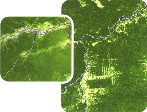
MODIS Vegetation Continuous Fields (VCF) Percent Tree Cover product, from South America.

Source: Derived from MODIS 500 m VCF Percent Tree Cover Product for 2000 - 2001, University of Maryland Global Land Cover Facility.
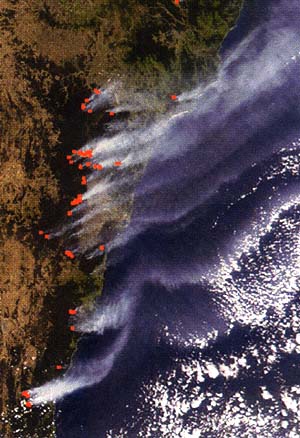
The Geostationary Operational Environmental Satellites (GOES)-based Automated Biomass Burning Algorithm (ABBA) system is being adapted for use by the European Meteosat Second Generation (MSG) and there is an agreement for a workshop to establish coordinated use of a network of geostationary operational satellites detecting active fires, to be held in Europe in 2004, involving representatives from Europe, Japan and North America. Daily global active-fire products are now being provided in near-real time by the Moderate Resolution Imaging Spectroradiometer (MODIS) instruments through the MODIS Rapid Response System. Data and imagery are being made available over the Web to a number of international GOFC-GOLD partners. Custom regional Web-GIS mapping is being developed for different regions, providing additional information on location and geographical context of fires.

TECHNOLOGY IMPROVEMENT
GOFC-GOLD is keen to promote new technology development, and has been involved in the evaluation and application development of the German Bi-spectral Infrared Detection (BIRD) small satellite technology. Partnerships have also been formed for international involvement in the development of the planned operational USA National Polar-orbiting Operational Environmental Satellite System (NPOESS).
WIDE-AREA COLLABORATION
Much of the work of the Implementation Teams is through regional networks, and considerable progress has been made in the establishment of operational regional networks in Fennoscandia, Central Africa, Southern Africa and Southeast Asia. Remote-sensing-derived products delimiting recently burned areas have been created and distributed for preliminary evaluation. These products are Global Burnt Area 2000 (GBA-2000) of the Joint Research Centre (JRC); Global Burn Scars (GLOBSCAR) of the European Space Agency (ESA); and MODIS.
There is an increasing recognition of the need for validation (accuracy assessment) of the products prior to their use. Collaboration has been strengthened with CEOS Cal/Val Working Group, setting up international validation sites, validation protocols and reporting standards.
To assess the accuracy of the burned-area remote-sensing products, validation protocols developed for Southern Africa are being extended to other regions. Collaboration for in situ validation with local partners is being organized by the GOFC-GOLD-Fire regional networks, including Angola, Australia, Botswana, Brazil, Malawi, Mozambique, Namibia, Russian Federation, United Republic of Tanzania, Ukraine, Zambia and Zimbabwe.
MODIS Vegetation Continuous Fields (VCF) Percent Tree Cover product, from South America.

Source: Derived from MODIS 500 m VCF Percent Tree Cover Product for 2000-2001, University of Maryland Global Land Cover Facility.
EXTENDING GLOBAL INTERACTION
GOFC-GOLD is recognized as a major partner and data provider for science initiatives, such as the Northern Eurasian Earth Science Partnership Initiative. Initial discussions were held on networks in India, extra-tropical South America, and Central America. GOFC-GOLD is encouraging the development of new European-led networks in West Africa and the Mediterranean, reflecting the needs of regional participants. There has also recently been progress in identifying potential partners in China.