A system to detect, assess and predict
global
and regional changes associated with land-based
and freshwater ecosystems along coasts
GOALS
The primary goal of the GTOS coastal initiative (C-GTOS) is to detect, assess and predict global and large-scale regional changes associated with land-based and freshwater ecosystems along coasts. As coastal areas have intensive human activity and are rich and diverse in natural resources, an understanding of coastal areas is of particular importance in guiding wise national and international policy decisions.
PROGRESS
C-GTOS made considerable progress in this biennium. An expert panel (see Box 1) has identified the framework for organizing observations and issues relevant to coastal ecosystems. An implementation plan is being developed and should be completed in early 2004. Members of the panel have been active in linking to other programmes (e.g. C-GOOS, LOICZ) through a proposed coastal theme within the Integrated Global Observing Strategy (IGOS). Issues that go beyond individual systems and involve use of satellite and remote imaging will be addressed through IGOS.
IMPLEMENTATION
Development of the implementation plan is progressing through a series of expert workshops. The first workshop took place at East Carolina University, Greenville, North Carolina, in October 2002. The second workshop was held at the Joint Research Centre of the Institute for Environment and Sustainability, Ispra, Italy, in March 2003. The third workshop was in La Selva, Costa Rica, in October 2003.
FRAMEWORKS AND PRODUCTS
Figure 1. Changes in night-time lights from 1992 - 93 to 2000 for Italy
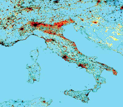
|
KEY: |
|
|
Cyan |
background - no lights and offshore(land/sea mask applied). |
|
Black |
bright lights detected in both time periods(at or near saturation). |
|
Red |
Lights much brighter in 2000. |
|
Yellow |
New lights in 2000. |
|
Light grey |
Dim lighting detected in both time periods - little change in brightness. |
|
Blue |
Lights dimmer or missing in 2000(relative to 1992-93). |
Source: Chris Elvidge of NOAA
There are several frameworks that provide a suitable structure for meeting the goals of C-GTOS. One is the Driver-Pressure-State-Impact-Response (DPSIR) framework that links ecological and socio-economic conditions and activities. Initially, selected "states" or attributes of coastal ecosystems were identified, including land use and land cover; human populations; quality of water and soil; habitat; sediment delivery; water cycle; and sea level. Monitoring of these states is the initial focus of the observing system. Variables to be monitored or point observations to detect any change in these states were described and linked to prospective sources of information. The Expert Panel then examined networks of programmes known to sample the coastal environment in ways that could support C-GTOS. This information was placed in the context of the TEMS coastal module (see page 6).
OBJECTIVES
The Expert Panel also identified initial short-term objectives and the products needed to establish the monitoring process. An initial narrow range of discrete elements have been selected to structure early activities of C-GTOS, namely:
Develop an inventory of sites appropriate for observations and analyses of delivery of water, solids and nutrients to coastal waters.
Construct a functional typology of the coast and evaluate the distribution of functional units. This recognizes that different environmental issues may have unique zones of influence on observed responses.
Integrate and improve the World Resources Institute Earth Trends coastal habitat maps and link them to land use and land cover.
Determine and analyse the distribution of coastal population, urbanization and land use, and their effects in the coastal zone.
Determine and analyse the distribution of conservation and cultural sites in the coastal zone.
These short-term products are designed to provide clear evidence of the value of C-GTOS. Longer-term products will then be developed once a community of observing sites is established and users become more engaged.
All C-GTOS activities are run with the financial support of the National Oceanic and Atmospheric Administration (NOAA), United States of America.
USEFUL LINKS
C-GOOS: GOOS Coastal module,
IGOS: Integrated Global Observing Strategy,
LOICZ: Land-Ocean Interactions in the Coastal Zone,
|
BOX 1. MEMBERS OF THE C-GTOS EXPERT PANEL · Martin ADRIAANSE |
