![]()
![]()
![]()
C.S. Kamara¹ and I. HaqueSoils and Plant Nutrition Section International Livestock Centre for Africa (ILCA)
PO Box 5689, Addis Ababa, Ethiopia
1. On leave from Soil Science Department, Njala University College, Sierra Leone
Abstract
Introduction
Materials and methods
Results and discussion
Acknowledgements
References
Soil moisture was measured for 53 weeks during 1986/87 at five sites along a toposequence in the Ethiopian highlands to determine the soil moisture storage capacity for improved cropping systems.
The major soils in the area are Alfisols in the uplands, Vertisols at the lower elevations, and soils with vertic properties between the two. The Alfisols never fully recharge to field capacity to a depth of 50 cm throughout the season, but Vertisols recharge above field capacity, with the adjacent soils receiving excess water only at 1 m depth. During the general vegetative, reproductive and maturation stages of crops in the area, the Vertisols stored 16, 19 and 37% more moisture, respectively, than the Alfisols. The Vertisols can be cultivated during the post-rainy season if the top 50 cm are irrigated to maximum recharge.
Large-scale improved management of specific soils is usually directed towards stabilising and sustaining crop production as a means to improve living standards. In general, participating farmers hold parcels of land with soils that might be different from those selected for improvement. In the Ethiopian highlands poorly drained Vertisols occur at the bottom of the toposequence, while well-drained upland soils are used for buildings, farmsteads, grazing, and food crop production. Development of production packages for other soils in the area along with the Vertisols will augment the adoption of the Vertisol packages (Jutzi et al, 1987). Such production packages should include characterisation of the soil moisture storage capacity necessary to maintain the stability of all soils within the area for crop production (Haque and Tothill, 1987).
The main purpose of characterising crop production constraints such as soil moisture storage capacity is to enable prediction of crop yields for specific soils under a given climate. For soils along a toposequence, the emphasis has been on predicting soil moisture patterns from some topography characteristics. Employing Horton's (1941) sheet erosion model, Burt and Butcher (1985) developed a topographic index for non-linear hillslopes that relates depth of moisture saturation to the area upslope (a) and the local hillslope gradient (s). Similar area-based indices had been employed to predict the area contributing to surface runoff (Beven and Kirkby, 1979), and distribution of soil moisture deficits within a subcatchment area (Beven and Wood, 1983). Anderson and Kneale (1982) observed that the a/s index was less accurate for shallow slopes because soil properties other than runoff from the upper part of the slope become important. This shortcoming of the relationship between a/s index and soil moisture distribution pattern is applicable to most of the lower slopes in the Ethiopian highlands where Vertisols occur.
Quantified shapes along slopes have been related to soil moisture patterns (Evans, 1980), and the problems of quantifying the shapes were discussed by Anderson and Burt (1980). Burt and Butcher (1985) compared the a/s index and the quantified shape aspects of the hillslopes for predicting soil moisture patterns along a toposequence in south Devonshire, England, but found the combined area base and shape index to be satisfactory only during wet periods.
Under a ustic soil moisture regime at Kathrine in Australia, Williams et al (1983) estimated that a profile moisture store of less than 100 mm had a less than 30% probability of meeting the moisture requirement of a sorghum crop, and even 200 mm had only a 70% probability of meeting the requirement. In the semi-arid areas of Australia, Williams and Probert (1983) reported fairly accurate prediction of dry-matter yield of Stylosanthes humilis using profile water store, rainfall, evaporation and temperature.
Rainfall amount, evaporation, air temperature, and soil type and position within the landscape are major considerations when assessing soil moisture storage capacity along a toposequence. Such assessment can lead to more efficient water management for crops, particularly in areas where the landscape is predominantly undulating and water can be limiting.
The major objectives of this study were to determine the soil moisture storage capacity in various soil types along a toposequence, and to determine and correlate periods of excess, adequate and deficit soil moisture to appropriate cropping systems for each soil.
Site and soils
This investigation was carried out at the ILCA Debre Zeit research station, located at latitude 8°44' N. longitude 38°58' E, and 1850 m altitude. The soils are classified as Alfisols in the upland region, Vertisols in lower-lying areas and an intermediate group with vertic properties in between. A detailed description of the pedon and physico-chemical properties of three profiles representing the Vertisols, Alfisols and the intermediate soils with vertic properties is reported elsewhere (Kamara and Haque, 1987).
Experimental procedures
On the toposequence with slopes ranging from 1 to 10%, five sites were selected based on soil type and slope length. At each site, three access tubes were installed 30 m apart across the slope (Figure 1).
Weekly soil moisture measurements were made from 1 July 1986 to 1 July 1987: with a neutron probe from 20 cm depth at 10 cm increments; and gravimetrically, using an 8-cm diameter, 5-cm long, core, from 0-10 cm depth. The area around each access tube was uncropped and kept free of weeds throughout the period. Monthly rainfall, evaporation and temperature for the experimental period were recorded at the ILCA Debre Zeit weather station (Table 1).
Figure 1. Diagram of the toposequence showing major soils and positions of access tubes.
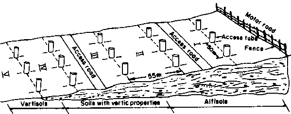
Table 1. Monthly rainfall, evaporation and temperature at the ILCA station, Debre Zeit, during the experimental period.
|
|
1986 |
1987 |
|||||||||||
|
Ja |
J |
A |
S |
O |
N |
D |
J |
F |
M |
A |
M |
J |
|
|
Rainfall (mm) |
174 |
112 |
193 |
111 |
12 |
0 |
0 |
0 |
20 |
219 |
84 |
172 |
61 |
|
Evap. (mm) |
139 |
134 |
149 |
138 |
243 |
269 |
270 |
357 |
273 |
174 |
201 |
205 |
153 |
|
Temp. (°C) |
|
|
|
|
|
|
|
|
|
|
|
|
|
|
max. 25 |
25 |
24 |
25 |
25 |
26 |
27 |
27 |
27 |
29 |
30 |
29 |
30 |
30 |
|
min. 10 |
10 |
10 |
9 |
8 |
6 |
6 |
7 |
8 |
8 |
11 |
10 |
10 |
9 |
a. Soil moisture measurements were taken from 1 July 1986 to 1 July 1987. However, as soil moisture values are affected by weather prior to measurement, June 1986 figures are also shown.
Soil moisture storage limits
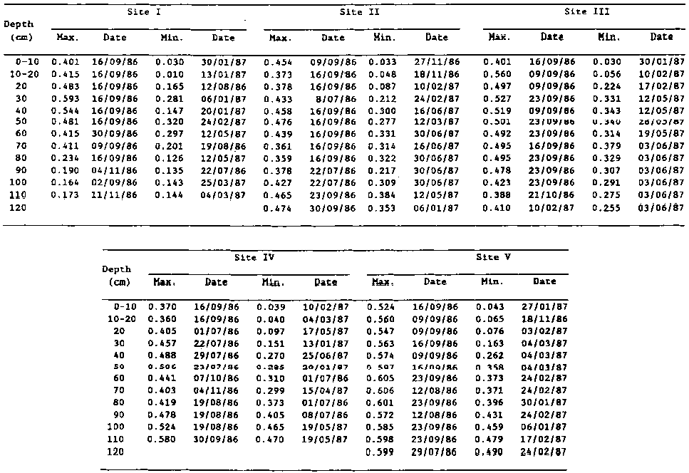
Table 2 shows soil moisture variation with depth at each of the five sites at maximum layer recharge (maximum) and at the driest layer condition (minimum). The maximum moisture recharge from the rains is an indication of the apparent maximum storage capacity of the soils at any depth and site. The magnitude of such a maximum store is affected by the soil texture and structure, which regulate the water transmission characteristics, the position of the site in the landscape, and the amount of rainfall. The top of the toposequence (site I) had a sandy loam texture at about 80 cm, while sites II to V had clay to loam-clay textures (Table 3) throughout the top 1 m, but the differences in the transmission of soil moisture down the profile cannot be attributed entirely to texture.
Maximum soil moisture recharge to an 80-cm depth was reached at sites I to III during September. Sites IV and V reached maximum moisture recharge to the 120-cm depth between July and September because these two sites received the runoff from sites I, II and III. Maximum moisture recharge should have been reached much earlier, but the delay might have been due to slow water movement through the heavy clay soil. The presence of cracks that could have allowed rapid water entry may be responsible for some of the lower depths reaching maximum recharge earlier than some upper layers.
The rate at which the minimum soil moisture was reached varied widely. Both the Alfisol (site I) and Vertisol (site V) appeared to dry faster than the intermediate soils (Table 2). The period during which this minimum occurred is critical to some crops. The extent of drying, expressed as a percentage of the maximum moisture at the 20-, 50- and 100-cm depths for the five sites, is given in Table 4. The Vertisol (site V) lost more moisture at the 20-cm depth, but its high moisture reserve at maximum recharge gave a much lower drying effect at the 50- and 100-cm depths.
Table 3. Particle size distribution and textural class for various depths along the toposequence.
|
Site |
Depth (cm) |
Sand (%) |
Silt (%) |
Clay (%) |
Textural class |
|
|
0-20 |
43 |
22 |
35 |
Gravelly clay loam |
|
|
20-40 |
27 |
24 |
49 |
Gravelly clay |
|
I |
40-60 |
32 |
26 |
42 |
Gravelly clay |
|
|
60-80 |
46 |
30 |
24 |
Loam |
|
|
80-100 |
64 |
22 |
14 |
Sandy loam |
|
|
0-20 |
40 |
28 |
32 |
Clay loam |
|
|
20-40 |
34 |
28 |
38 |
Clay loam |
|
II |
40-60 |
34 |
26 |
40 |
Clay |
|
|
60-80 |
30 |
26 |
44 |
Clay |
|
|
80-100 |
26 |
24 |
50 |
Clay |
|
|
0-20 |
36 |
26 |
38 |
Clay loam |
|
|
20-40 |
33 |
36 |
31 |
Clay loam |
|
III |
40-60 |
28 |
32 |
40 |
Clay loam |
|
|
60-80 |
27 |
30 |
43 |
Clay |
|
|
80-100 |
29 |
16 |
55 |
Clay |
|
|
0-20 |
30 |
35 |
35 |
Clay loam |
|
|
20-40 |
33 |
36 |
45 |
Clay |
|
IV |
40-60 |
32 |
31 |
37 |
Clay loam |
|
|
60-80 |
24 |
27 |
49 |
Clay |
|
|
80-100 |
24 |
25 |
51 |
Clay |
|
|
0-20 |
11 |
42 |
47 |
Silty clay |
|
|
20-40 |
31 |
31 |
37 |
Clay loam |
|
VI |
40-60 |
33 |
28 |
39 |
Clay loam |
|
|
60-80 |
22 |
39 |
39 |
Clay loam |
|
|
80-100 |
27 |
24 |
49 |
Clay |
Table 4. Extent of drying (%) along the toposequencea.
|
Depth (cm) |
Sites |
||||
|
I |
II |
III |
IV |
V |
|
|
20 |
66 |
77 |
55 |
76 |
86 |
|
50 |
33 |
42 |
32 |
44 |
40 |
|
100 |
17 |
28 |
31 |
11 |
22 |
a. Derived from Table 2 and expressed as a percent of the maximum moisture recharge.
The lower elevation Vertisols will be able to support deep-rooted crops. Because of the excessively dry top 20 cm, these soils will require supplemental irrigation to support an existing crop with deep roots or double cropping with shallow-rooting crops.
Supplementary irrigation for post-rainy season crop production in Vertisols is necessary, as suggested by Kanwar et al (1982) and Haque et al (1986). Using data from Table 2 for site V at the 0-1 m depth, the maximum recharge was calculated as 578 mm, while the minimum moisture in the profile was 271 mm. For the top SO cm of the profile, the maximum moisture was 279 mm and the minimum was 75 mm, while at the SO-100 cm depth the maximum was 298 mm and the minimum was 196 mm. While the top 1 m of the soil profile was depleted by 47%, the top SO cm was depleted by 73%, and the SO-100 cm layer was depleted by only 25%. It is the top SO cm that shows the greatest need for supplementary irrigation: to bring this top layer to maximum moisture-holding capacity, the top 20 cm will require 98 mm of water, the 20-40 cm layer 79 mm, and the 40-50 cm depth 28 mm. Drying is greatest at the 0-40 cm depth and is attributed to the depth of cracks-up to 45 cm - (Kamara and Haque, unpublished data).
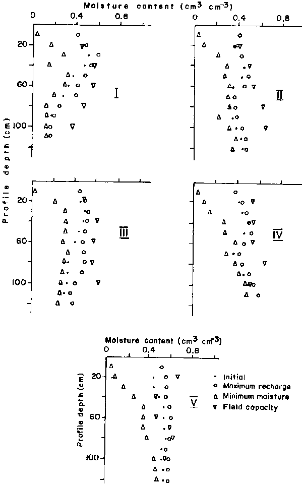
Field capacity along the toposequence was determined by the pressure plate technique at 0.03 MPa (Figure 2). A fully recharged profile is one in which the recharge from the rain is equal to the moisture content at field capacity. The soils on the upper slopes (sites I, II and III) were never fully recharged to a depth of SO cm, which implies that crops with roots of SO cm or longer would need more moisture. Crops with roots less than SO cm long would be suitable in this part of the landscape. The moisture recharge of the Vertisol (site V) was above field capacity at the 20-120 cm depth. Crop production under such conditions requires either crops that are not susceptible to waterlogging, or removal of excess water through drainage.
Alternatively, since the water above field capacity at the SO-cm depth for site V can be 63% more than that lost by drying, supplemental irrigation applied to the top 50 cm at the time of minimum soil moisture (Table 2) will support a double cropping system on this part of the toposequence. The soils with vertic properties that are adjacent to the Vertisols were in general fully recharged, and had excess water only at the 1-m depth.
Figure 2. Soil moisture status at sites along the toposequence.
Seasonal moisture dynamics
Profile moisture status at the five sites along the toposequence was plotted for the weeks beginning 12 August 1986 (week 7), 28 October 1986 (week 18), 9 December 1986 (week 24), and 16 June 1987 (week 51) (Figure 3). The dates roughly represent the vegetative growth, reproductive and maturity stages of crops, and the fallow period/planting time for the area, respectively.
The highest moisture store was recorded during the vegetative growth stage: for site I, 0.52 cm³ cm-3 at 30 cm; site II, 0.43 cm³ cm-3 at 40 cm; site III, 0.50 cm³ cm-3 at 30 cm; site V, 0.61 cm³ cm-3 at 50 cm. The area received 42 mm of rainfall during week 7, which partly explains the values during that period; the other periods had no rain at sampling time (Figures 4a and 4b). At site IV, the highest moisture content of 0.52 cm³ cm-3 at 60 cm was recorded during week 18.
Russell (1978) measured the moisture profiles of an uncropped deep Vertisol at the International Crops Research Institute for the Semi-Arid Tropics (ICRISAT), India, during the rainy season (14 June to September 1977) and during the post-rainy season (6 October 1977 to 11 April 1978). The highest moisture contents recorded were 0.45 cm cm-3 at 1.0 m on 7 September during the rainy season and 0.50 cm³ cm at 1.2 m on 6 October during the post-rainy season. Russell (1978) did not report on the moisture profiles for the associated Alfisols in the area, but concluded that an adequate agronomic description of a soil moisture profile must indicate when, where and how much water is available in the soil throughout the growing season.
Figure 3. Moisture profiles at various times at sites along the toposequence.

Figure 4a. Dynamics of soil moisture storage at three depths at sites along the toposequence during the vegetative growth stage (A).

Figure 4a. Dynamics of soil moisture storage at three depths at sites along the toposequence during the reproductive stage (B).

Figure 4b. Dynamics of soil moisture storage at three depths at site V on the toposequence during the maturity/harvest or fallow stage.
The dry fallow period (week 24) and wetting (planting time week 52) period were characteristic for the Vertisols (site V). The drying effect was distinct down to 1 m and thereafter the wetting and drying effect were not discernable.
The presence of cracks enhanced the deep wetting and drying in the Vertisols, which remained wet at 1 m and below with a moisture content of >0.60 cm³ cm-3 (Figures 2 and 3).
At 1 m during the vegetative stage, site I had 0.16, site II 0.39, site III 0.41, and site IV 0.50 cm³ cm-3. These moisture storage differences along the toposequence are important for agronomic assessment of the soils.
Annual soil moisture dynamics
The annual soil moisture measurements were divided and linked with general crop production stages in the area. Three stages were identified: vegetative growth stage (mid-June to mid-August), reproductive stage (mid-August to mid-September) and maturity/harvest stage and fallow (mid-September to mid-June).
Vegetative growth stage
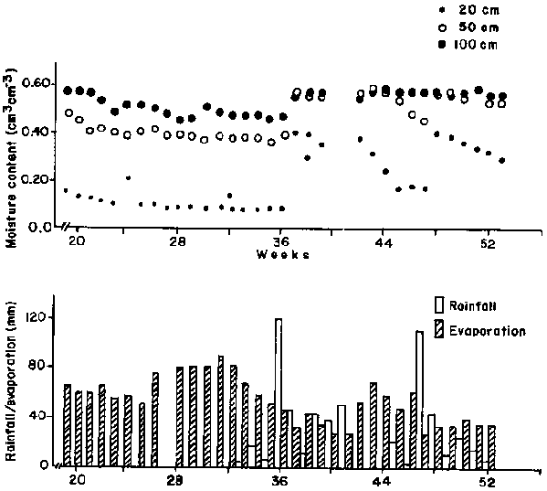
Figure 4a(A) shows soil moisture status at three depths for the five =sites during the vegetative growth stage, along with rainfall and pan evaporation for the same period. Most crops are planted from mid-June; crops such as maize reach their maximum growth stage around mid-August.
Weekly water input was 3-60 mm with a potential apparent loss of 26-37 mm. Average weekly rainfall and evaporation were respectively 32.9 and 30.7 mm. These weekly values are important because they influence the soil water store available for crop growth at each depth.
Total soil moisture store within the top 1 m can be estimated by the minimum and maximum soil moisture at 20, 50 and 100 cm: the range of stored soil moisture within the top 1 m was 30.15-0.51 cm³ cm-3 for site I and 0.40-0.61 cm³ cm-3 for the Vertisol at site V, which stored 16% more moisture than the Alfisol. The range for each depth and site indicates the soil moisture regime under which a specific crop can grow (Table 5). Crops in site V will have 3 times more moisture available to them than crops at site I.
Soil moisture at the 20-cm depth in site I was always higher than at the 50- and 100-cm depths. In site IV, the 50- and 100-cm depths were always wetter than the 20-cm depth. At site V, soil moisture will move primarily down the profile, while in site I movement will be largely lateral in the form of runoff, which will leave little water to percolate into the profile. The patterns at sites II, III and IV were intermediate.
Reproductive stage
This period marked the decline of soil moisture at all sites, particularly at the 20-cm depth (Figure 4a(B). The Alfisol site remained dry. As a result of increased evaporation and no rainfall during week 12, the 20-cm depth dried much more rapidly than the 50- and 100-cm depths.
The rate of soil moisture loss was higher at sites I and V than at sites II, III and IV. Sites I and V lost 0.04 cm³ cm-3 per week compared to 0.023-0.028 cm³ cm-3 in sites II, III and IV. The high soil moisture loss at the 20-cm depth in site V could have been caused by the development of cracks. Because of this rapid and large soil moisture loss, crops with a shallow root system will experience a sudden moisture deficit that can cause wilting, premature ripening and quality loss. Moisture at the 50-cm and 100-cm depths was 0.55-0.60 cm³ cm-3 at site V and <0.55 cm³ cm-3 at the other sites. The Vertisol (site V) stored 19% more moisture than site I (Table 5).
Maturity/harvest or fallow
The decline in soil moisture during the reproductive period continued during the maturity/fallow period. The 20-cm depth reached minimum soil moisture during weeks 33-35 for site V (Figure 4b). Site V had the driest soil at 20 cm (Table 5). There was a fourfold increase in soil moisture at 20 cm due to 120-mm rainfall during week 36 and 110-mm rainfall during week 48. However, these rains only slightly increased moisture levels at 50 cm and 100 cm. These are the small rains (Daniel Gamachu, 1977) for this area.
Table 5. Variability of soil moisture (cm³ cm-3) during three periods et three depths along the toposequence.
|
Depth (cm) |
Sites |
||||
|
I |
II |
III |
IV |
V |
|
|
Vegetative stage |
|||||
|
20 |
0.444-0.511 |
0.313-0.400 |
0.438-0.490 |
0.340-0.400 |
0.399-0.535 |
|
5O |
0.342-0.400 |
0.372-0.426 |
0.435-0.460 |
0.395-0.480 |
0.524-0.608 |
|
100 |
0.149-0.161 |
0.377-0.427 |
0.338-0.359 |
0.467-0.529 |
0.537-0.572 |
|
Reproductive stage |
|||||
|
20 |
0.271-0.483 |
0.223-0.378 |
0.362-0.497 |
0.230-0.381 |
0.189-0.547 |
|
50 |
0.365-0.481 |
0.425-0.476 |
0.433-0.501 |
0.344-0.506 |
0.505-0.597 |
|
100 |
0.148-0.164 |
0.381-0.411 |
0.330-0.423 |
0.454-0.524 |
0.545-0.585 |
|
Maturity stage/harvest/fallow |
|||||
|
20 |
0.165-0.340 |
0.087-0.274 |
0.241-0.424 |
0.097-0.289 |
0.076-0.405 |
|
50 |
0.120-0.367 |
0.277-0.425 |
0.340-0.443 |
0.285-0.483 |
0.358-0.575 |
|
100 |
0.143-0.187 |
0.353-0.469 |
0.291-0.429 |
0.465-0.522 |
0.421-0.582 |
While soil moisture at 50 cm and 100 cm in site V was 0.36-0.58 cm³ cm-3 during the period site I had soil moisture of 0.19-0.37 cm³ cm-3; the Vertisol of site V stored 37% more moisture than site I (Table 5). The larger amount of stored moisture during this fallow period has important implications for systems such as double cropping and alley cropping. The moisture at these depths during this period is similar to the other periods when there was rainfall (Figure 3).
These measurements indicate that the Vertisols remain moist or wet throughout the year at SO and 100 cm. The influence of cracks (which can be up to 45 cm deep) on soil moisture depletion during the fallow period is negligible at the 50-100 cm depth (Figure 4b). The soils should be able to support a second crop if the top 20 cm can be wetted to maximum recharge (98 mm) with supplemental irrigation.
The low soil moisture content in site I, particularly at 100 cm, provides little insurance during a dry year or erratic dry spells. While early planting on the Vertisol at site V may be promising, even during a dry year, early planting would be unwise in the Alfisols at the top of the toposequence since they store little soil moisture. A scaling of the intermediate soils based on stored soil moisture will provide a useful guide for cropping along the toposequence by making maximum use of the soil moisture at each site to improve crop yields.
This work was partly funded by the Vertisol Management Project with funds from the governments of Switzerland, Norway and Finland. The ILCA Soils and Plant Nutrition Section staff at Debre Zeit are specially acknowledged for their help with data collection.
Anderson M G and Burt T P. 1980. Towards more detailed field monitoring of variable source areas. Water Resources Research 14:11231131.
Anderson M G and Kneale P E. 1982. The influence of low-angled topography on hillslope: Soil-water convergence and stream discharge. Journal of Hydrology 57:65-80.
Beven K J and Kirkby M J. 1979. A physical based, variable contributing area model of basin hydrology. Hydrological Sciences Bulletin 24:43-69.
Beven K J and Wood E E. 1983. Catchment geography and the dynamics of runoff contributing areas. Journal of Hydrology 65:139-158.
Burt T P and Butcher D P. 1985. Topographic controls of soil moisture distributions. Journal of Soil Science 36:469-486.
Daniel Gamachu. 1977. Aspects of climate and water budget in Ethiopia. Addis Ababa University Press, Addis Ababa, Ethiopia. 71 pp.
Evans I S. 1980. An integrated system of terrain analysis and slope mapping. Zeitschrift fur Geomorphologie Supplemenband 36:274-295.
Haque I and Tothill J C. 1987. Forages and pastures in mixed farming systems of sub-Saharan Africa. Paper presented at the Second Regional Workshop on Land Development and Management of Acid Soils in Africa, Lusaka, Zambia, 9-16 April 1987.
Haque I, Jutzi S and Nnadi L A. 1986. Management of Vertisols for increased and stabilized food and feed production in Ethiopian highlands. Paper presented at the IAR (Institute of Agricultural Research) Workshop on Soil Science Research in Ethiopia held at ILCA, Addis Ababa, 11-14 February 1986.
Horton R E. 1941. Sheet erosion: past and present. Transactions of the American Geophysical Union. pp. 299-305.
Jutzi S. Anderson F M and Abiye Astatke. 1987: Low-cost modifications of the traditional Ethiopian tine plough for land shaping and surface drainage of heavy clay soils: Preliminary results from on-farm verification trials. ILCA Bulletin 27:28-31.
Kamara C S and Haque I. 1987. The characteristics of Vertisols at ILCA's research and outreach sites in Ethiopia. PSD Working Document No. B5. International Livestock Centre for Africa (ILCA), Addis Ababa, Ethiopia. 87 pp.
Kanwar J S. Kampen J and Virmani S M. 1982. Management of Vertisols for maximizing crop production - ICRISAT experience. In: Vertisols and rice soils of the tropics Twelfth International Congress of Soil Science New Delhi, India, 8-16 February 1982. Indian Society of Soil Science, New Delhi, India. pp. 94-118.
Russell M B. 1978. Profile moisture dynamics of soil in Vertisols and Alfisols. Proceedings of the International Workshop on the Agroclimatological Research Needs of the Semi-Arid Tropics. ICRISAT, 22-24 November 1978. Hyderabad, India. pp. 75-87.
Williams J and Probert M E. 1983. Characterization of the soil climate constraints for predicting pasture production in the semiarid tropics. Proceedings of the International Workshop on Soils. ACIAR (Australian Council for International Agricultural Research), Townsville, Australia. pp. 61-75.
Williams J. Day K D, Isbell R F and Reddy S J. 1983. Climate and soil constraints to agricultural development. In: R C Muchow (ea.), Agro-research for the semi-arid tropics: North-west Australia. University of Queensland Press, Brisbane, Australia.
![]()
![]()
![]()