![]()
![]()
![]()
Hydrography
Bottom conditions
Acoustic survey
Fishery
Surface observations
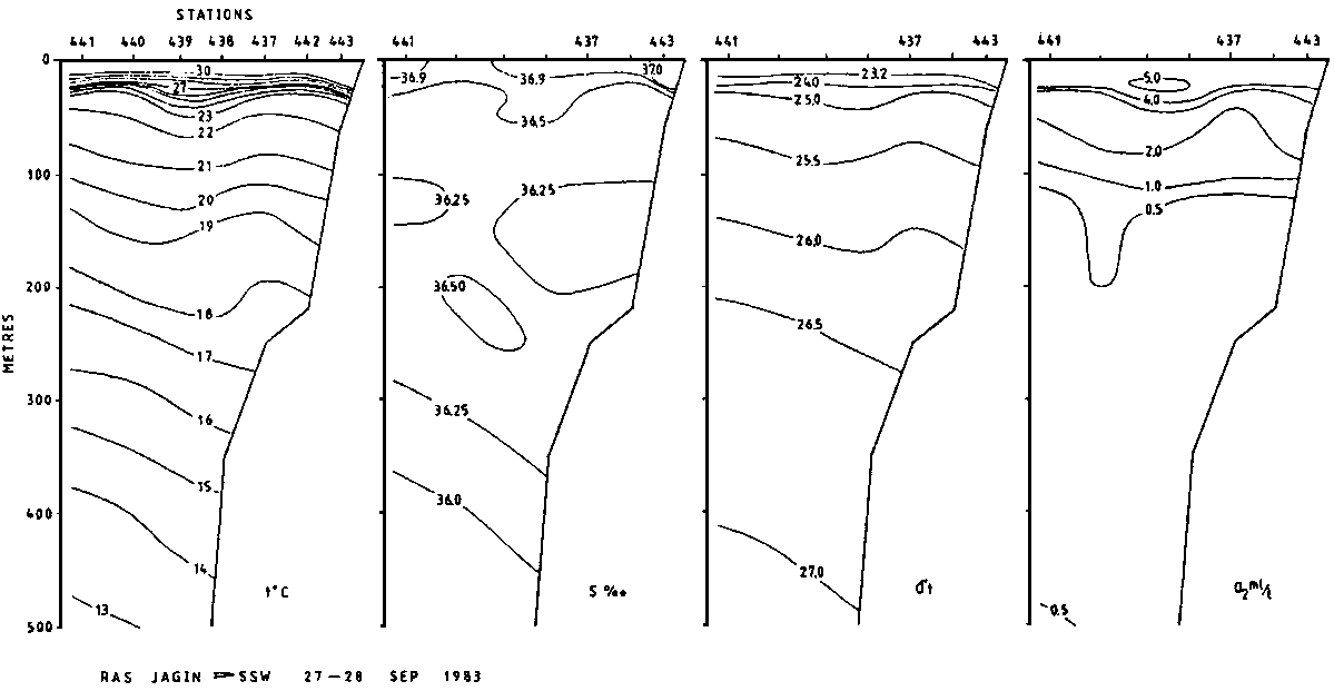
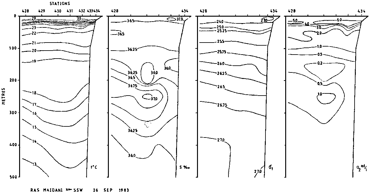
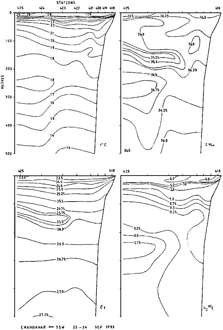
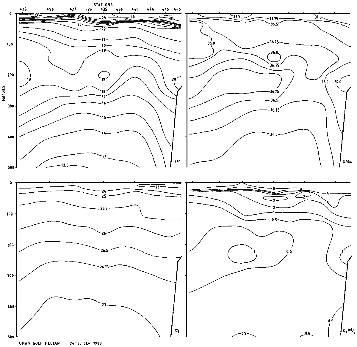
Four hydrographical transects were worked from the coast to the median line of the Gulf. The distributions of temperature, salinity, density and oxygen contents are given in Figures 2-5. Some additional stations were worked along the median, and a Gulf median section is presented in Figure 6. Measurements were made at standard depths to 500 m.
The temperature in the surface layer was measured to 30-31°C at the head of the Gulf, decreasing eastwards to 28-29°C. Likewise, the salinity was above 37 permille at the Ras al Kuh transect, decreasing to 36.5 off Chahbahar. A sharp thermocline was found at 20-40 m depth, from 29-30°C to 22-23°C. Between 100 and 200 m a minimum of temperature and salinity was recorded, and an intermediate maximum was observed between 200 and 300 m. In the deeper layers temperature decreased to 14°C at the head of the Gulf and 12.5 further east (500 in depth). The salinity was below 36 permille in the deeper layer, a little above at the head of the Gulf.
The intermediate layer of higher temperature and salinity is caused by an outflow of Persian Gulf water over the threshold at the Straits of Hormutz.
At the easternmost transect (Fig. 5) an intermediate layer (100-200 m) of water of lower salinity was observed. This represents a vertical stability as can be seen from the ot distribution. This phenomenon seems difficult to explain. However, the data were carefully checked for any errors, but no faults were found. The phenomenon was observed at three successive stations.
Oxygen contents at the surface varied between 4.5 and 5 ml/l and at 100 m depth it is about 1 ml/l, a little higher at the head of the Gulf, lower in the eastern part.
Bottom suitable for demersal trawling was found on the shelf along most of the coast. The edge of the plateau lay between 50 and 200 m and the slope was in many places very steep and presented difficult trawling conditions. In the western part areas of soft mud and clay impeded trawling as the otter boards would get stuck. Hard, uneven bottom was found near shore in Ras al Kuh - Ras al Shir region, and a trawl bag was lost south of Ras al Kuh (Stn No. 41).
Some stretches along the coast had shallow waters far offshore where it was impossible for the vessel to operate. Generally the bottom slopes evenly from the beach with few or none underwater rocks or reefs.
Settings and performance of acoustical instruments are given in ANNEX III.
The 38 kHz sounder system was used as the main instrument for integration of echo abundance. Integrator values, measured in millimetres, were averaged over 5 nautical miles intervals, and later divided into four categories: pelagic fish, demersal fish, mesopelagic fish and plankton.
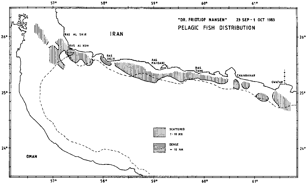
Fig. 7. Pelagic fish distribution (integrated echo intensities in mm per nautical mile).
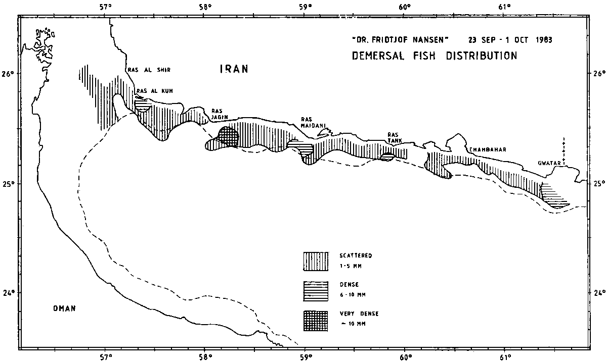
Fig. 8. Demersal fish distribution (integrated echo intensities in mm per nautical mile).
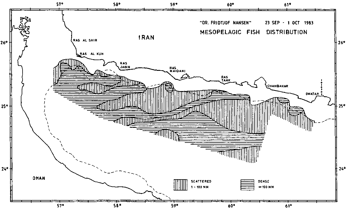
Fig. 9. Mesopelagic fish distribution (integrated echo intensities per nautical mile).
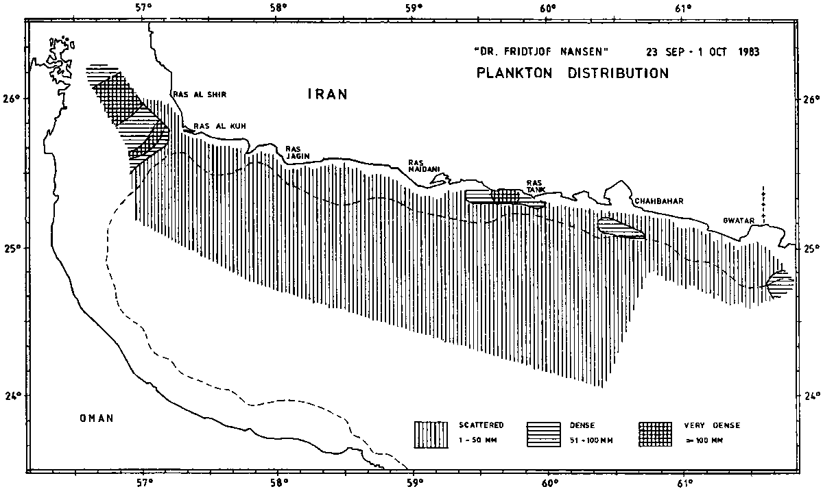
Fig. 10. Plankton distribution (integrated echo intensities per nautical mile).
The integrated echo intensities for each category are presented in Figs 7-10.
For estimation of fish biomass (B) the equation B = ![]() A C has been used, where
A C has been used, where ![]() is average integrator value and A is area. C = 0.8
is average integrator value and A is area. C = 0.8 ![]() tonnes/n. mile2. The method is described in detail in previous “Nansen”
reports (e.g. Strømme 1983).
tonnes/n. mile2. The method is described in detail in previous “Nansen”
reports (e.g. Strømme 1983).
The acoustic data of the present survey give:
|
Pelagic fish |
50,000 tonnes |
|
(based on an average fish length of 17 cm) |
|
|
Demersal fish |
200,000 tonnes |
|
( |
|
It should also be kept in mind that acoustic estimation of demersal fish is doubtful, as fish close to the bottom is not recorded by the sounder, and in shallow waters the scaring effect of the vessel may alter the natural situation.
Pelagic fish
Demersal fish
Cartilaginous fishes
Cephalopods
Crustaceans
Mesopelagic fish
Plankton
Details of fishing stations with dominant species are given in ANNEX I. Length frequency distributions of some species are presented in ANNEX II.
Figure 7 shows that recordings of pelagic fish was restricted to the shelf area mainly. No large schools were recorded, but somewhat denser concentrations were found south of Ras al Kuh. In some areas the sice-scanning sonar recorded several small schools in the upper layer.
The schools of small pelagic fish being small, few and far apart, the situation was not ideal for aimed trawling with pelagic trawl. The catches of these species were mainly taken at daytime when the fish stands closer to the bottom.
A few catches held some Selar crumenophthalmus and Trachurus indicus. Only a few specimens of Decapterus were caught. One good catch of anchovy Thryssa sp. was made, with bottom trawl (Stn No. 34) at 98 m depth. Clupeids were also scarce: a few Ilisha sp. and Opisthopterus tardoore were taken.
Of larger species, Scomberoides commersonianus, Scomberomorus guttatus, Megalaspis cordyla and various Caranx/Carangoides spp. were caught in small quantities.
Demersal fish distribution is presented in Figure 8. Some denser concentrations were recorded off Gwatar, Ras Tank, Ras Maidani, Ras Jagin and Ras al Kuh, but generally the registrations were poor.
The eastern region seemed to be the better for high grade food fish.
Quantitatively the most important contributors to the catches were hairtail (Trichiurus lepturus), threadfin breams (Nemipteridae), croakers (Sciaenidae), sweetlips (Pomadasyidae) and groupers (Serranidae). Catfish (Ariidae) dominated two catches in the east.
Fairly good catches of fairsized Pomadasys hasta were made in the eastern region at depths less than 50 m.
Otolithes ruber was present in fair number in the first haul off Gwatar Bay but became scarce further west where smaller Sciaenids were relatively abundant, especially in the deeper hauls.
Of the groupers the Epinephelus diacanthus was the most abundant, while larger species of the genus were represented with single specimens in a few catches.
Threadfin breams, Nemipterus japonicus and Nemipterus sp. (metopias?), both juveniles and adults, were found at depths between 50 and 120 m.
A few small sharks, mainly Rhizoprionodon acutus and Mustelus sp. were caught throughout the area. Butterfly ray (Gymnura sp.) was plentiful in the first trawl haul, but further west rays were few in number. Single specimens of guitarfish (Rhinobatus sp.) occurred throughout the area.
Sepia spp., mainly small specimens, occurred in most catches, and also a few large specimens of Sepia pharaonis. At bottom trawl station No. 13 at 148 m depth, small cuttlefish contributed the bulk of the catch (722 kg/hour).
Only a few specimens of shrimp were caught. No promising shrimp grounds were found, but somewhat better results might have been obtained with gear specially designed for this purpose.
The sand lobster (Thenus orientalis) were present in many catches, but with single or a few specimens only.
Mesopelagic fish distribution is given in Figure 9. The expected diurnal migration pattern was observed: in daylight schools and scattering layers at 150 m and deeper, ascending at nightfall to the upper 50 m and again descending at daybreak. The densest concentrations were found between 150 and 200 m near the slope in daytime. An echogramme of such recordings is given in Figure 11.
Fig. 11. Day recording of mesopelagic fish (Benthosema pterotum) in dense concentration close to the slope.
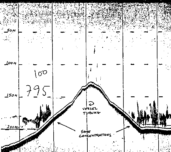
Samples of lanternfishes were brought to the University of Bergen and were identified as Benthosema pterotum by Dr. Jakob Gjøsæter.
Species of the families Nomeidae and Harpadontidae contributed a fair share in some hauls.
The mesopelagic fish data, both acoustical and biological will be further analysed in studies of the mesopelagic community in the Gulf of Oman.
Plankton distribution is given in Figure 10. Dense concentrations of jellyfish were found in some areas, but generally the catches contained only a few specimens. In shallow waters (19 m depth) off Ras Maidani, the pelagic trawl towed at the surface was filled with jellyfish, and the catch was estimated to 40 tonnes in half an hour.
No “krill” was found in the trawl catches. No plankton net samples were collected.
A few surface schools of small pelagic fish were observed in the east between Gwatar and Chahbahar.
Only on two occasions were whales observed: a large flock (about 200) of dolphins at position 25°20'N 58°41'E, and some few animals between Ras al Kuh and Ras al Shir.
![]()
![]()
![]()
 = 27
cm)
= 27
cm)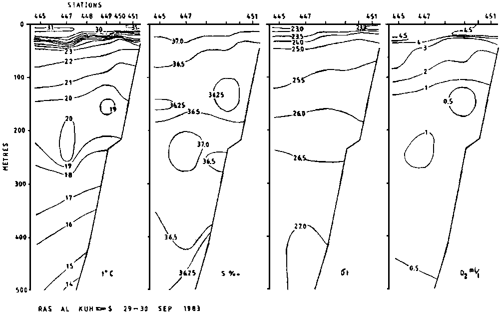