![]()
![]()
![]()
KL Srivastava, Mesfin Abebe, Abiye Astatke, Mitiku Haile and Hailu Regassa
Introduction
Land and soil features
Distribution
Land use
Study sites
Importance
Vertisols are characterised by their extensive cracking from the surface to depths of 50 cm or more with seasonal drying and also gilgai microrelief or subsoils showing slicker-sides or spheroid structures as evidence of seasonal expansion and contraction (Probert et al, 1987). These soils generally have a weak horizon differentiation.
These soils are distributed around the 45°N latitudes, mainly in the tropical and subtropical areas of the world. Driessen and Dudal (1989) report an estimated 311 million ha of Vertisols or 2.4 per cent of the global land area. Vertisols occupy about 105 million ha in Africa (Blokhuis, 1982) and about 12.6 million ha in Ethiopia.
Ethiopia can broadly be divided into highlands (areas above 1500 m altitude) and lowlands (area below 1500 m altitude). The highlands cover 40% of the land mass but account for about 95% of all cultivated land, accommodating 88% of the total human population and 70% of the total livestock population. Also 90% of the economic activity is concentrated in these areas (Constable, 1984).
This chapter describes the distribution, use and importance of Vertisols in the country and indicates the location of study sites of the Joint Vertisol Project (JVP).
Parent materials and landscape features
In the central highlands of Ethiopia, the main soil parent material is olivine basalt of tertiary age. Materials of more recent age like tuffs, cinders and finer ash, mainly of basic nature are also common parent materials (Ahmad, 1983; Mitiku Haile, 1987).
The largest extents of Vertisols are found on the volcanic plateaux. Colluvial slopes and sidelopes of volcanoes are found in the central highlands, on the colluvial slopes and alluvial plains along the Sudan border and on the vast limestone plateaux of central Hararge. They are also found in sites such as granitic colluvium in basins with seasonal drainage deficiencies in southern Sidamo. Sandstone colluvium are found in valleys in Tigray and the flood plains of the Wabe Shebele and Fafen rivers in the Ogaden (FAO, 1985).
The general slope range of the landscape on which Vertisols occur is 0-8% (Berhanu Debele, 1985). They are more frequent in 0-2% slope range and are usually found in the landscapes of restricted drainage such as seasonally inundated depressional basins, deltas, alluvia/colluvial plains, pyroclastic plains, undulated plateaux, valleys and undulating sideslopes (Berhanu Debele, 1985). Vertisols are usually associated with Nitosols, Cambisols, Lithosols, Andosols and Luvisols (Mitiku Haile, 1987). The association of Vertisols with other soils and their catenary positions are described by Fisseha Itanna (1992). Classification of some typical pedons is given in Table 1.
Soil characterisation
Soil characterisation helps in interpreting experimental results and serve as a guide to scientific soil management. Soil colour, depth-to-root-restricting layer, texture etc can be used to characterise soils.
Colour
Soil colour has been an important criterion for recognising and differentiating Vertisols by farmers and also by scientists (Kamara and Haque, 1988a; Mitiku Haile, 1991). Vertisol with a moist chrome of 1.5 or less within the upper 30 cm is grouped as pellic Vertisol; it is called a chromic Vertisol when the moist chrome is greater than 1.5. Fig. 1 shows major areas of pellic and chromic Vertisols in Ethiopia. The main study sites of JVP have also been characterised on the basis of soil colour (Table 2). Marked changes in colour as a function of topographic position, drainage and free iron content are also commonly observed (Table 3).
Texture
Vertisol profiles at several sites have been characterised by Kamara and Haque (1988a) and Mitiku Haile (1987). Table 2 includes information on clay content at nine sites.
Table 1. Classification of the pedons studied according to Soil Taxonomy and FAO/UNESCO systems.
|
Pedon |
Order |
Suborder |
Great group |
Subgroup |
Family |
FAO/UNESCO |
|
P49 |
Alfisol |
Ustalf |
Haplustalf |
Udic Ultic Haplustalf |
Udic Ultic Haplustalf, Clayey-skeletal, mixed isothermic |
Orthi-Umbric Nitosol |
|
Holetta |
Alfisol |
Ustalf |
Haplustalf |
Ultic Haplustalf |
Ultic Haplustalf fine mixed isothermic |
Haplic Nitosol |
|
Woserbi |
Alfisol |
Ustalf |
Rhodustalf |
Udic Rhodustalf |
Udic Rhodustalf, very fine mixed isothermic |
Dystri-Rhodic Nitosol |
|
P47 |
Entisol |
Orthent |
Ustortbent |
Lithic Ustortbent |
Lithic Ustortbent, loam mixed isothermic |
Entric Regosol |
|
P34 |
Mollisol |
Ustoll |
Haplustoll |
Lithic haplustoll |
Lithic Haplustoll, loamy mixed isothermic |
Haplic Phaeozem |
|
P38 |
Vertisol |
Ustert |
Chromostert |
Typic Chromostert |
Typic Chromostert, fine montmorillonitic isothermic |
Chromi-Entric Vertisol |
|
P102 |
Ustoll |
Ustoll |
Argiustoll |
Vertic Argiustoll |
Vertic Argiustoll, very fine clay mixed isothermic |
Verti-Luvic Phaeozem |
|
Sokoru |
Ustoll |
Ustoll |
Haplustoll |
Pachic Haplustoll |
Pachic Haplustoll fine mixed isothermic |
Haplic Phaeozem |
|
P4 |
Ustert |
Ustert |
Chromostert |
Paleustollic Chromustert |
Paleustollic Chromustert fine mixed isothermic (calcaereous) isothermic |
Chromi-Dystric Vertisol |
|
P100 |
Ustert |
Ustert |
Pellustert |
Typic Pellustert |
Typic Pellustert, very fine montorillontic (calcareous) isothermic |
Pelli-Eutric Vertisol |
|
P135 |
Vertisol |
Ustert |
Pellustert |
Typic Pellustert |
Typic Pellustert, very fine montorillontic (calcareous) isothermic |
Pelli-Eutric Vertisol |
|
P148 |
Vertisol |
Ustert |
Pellustert |
Typic Pellustert |
Typic Pellustert, very fine montorillontic (calcareous) isothermic |
Pelli-Eutric Vertisol |
|
P248 |
Vertisol |
Ustert |
Pellustert |
Typic Pellustert |
Typic Pellustert, very fine montorillontic (calcareous) isothermic |
Pelli-Eutric Vertisol |
|
Tulu Guracha |
Vertisol |
Ustert |
Pellustert |
Typic Pellustert |
Typic Pellustert, very fine montorillontic (calcareous) isothermic |
Pelli-Eutric Vertisol |
|
P45 |
Vertisol |
Ustert |
Pellustert |
Typic Pellustert |
Typic Pellustert, very fine montorillontic (calcareous) isothermic |
Pelli-Eutric Vertisol |
|
P336 |
Vertisol |
Ustert |
Pellustert |
Typic Pellustert |
Typic Pellustert, very fine montorillontic (calcareous) isothermic |
Pelli-Eutric Vertisol |
|
P44 |
Mollisol |
Ustoll |
Haplustoll |
Cumulic Udorthentic Haplustoll |
Cumulic Udorthentic Haplustoll, fine mixed (calcareous) isothermic |
Orthi-Calcaric Phaeozem |
|
Tulu Dimtu |
Inceptisol |
Ochrept |
Ustochrept |
Vertic Ustochrept |
Vertic Ustochrept, fine mixed isothermic |
Orthi-Vertic Cambisol |
Depth-to-root-restricting layer
Layers of bed rock, coarse sand and gravel occurring at shallow depths restrict root growth because they hold little water and few plant nutrients or offer mechanical impedance. For example, the subsoils of Were Ilu and Deneba included layers of rock, coarse sand and boulders at less than 1 m depth (Kamara and Haque, 1988a). Table 4 shows the available water capacity and soil physical characteristics of selected pedons in the central highlands.
Figure 1. Provisional soil association map of Ethiopia. Vertisols distribution and on-farm verification sites.
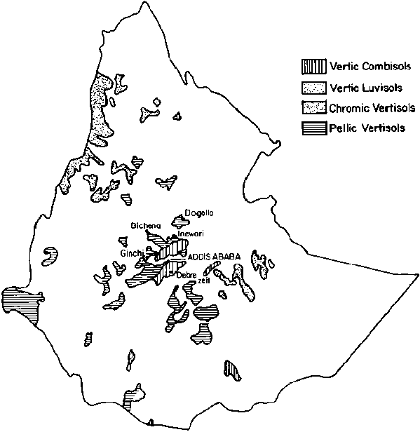
Source: Land Use Planning and Regulatory Department, Ministry of Agriculture, Addis Ababa, Ethiopia, 1984.
Table 2. Agroclimatic and general information for the main study sites of the Joint Vertisol Project.
|
Site |
Altitude (m asl) |
Annual rainfal (mm) |
Vertisol great group (based on colour) |
Soil depth (cm) |
Clay (%) (surface layer) |
Agro-ecological zone |
Physiographic region |
Zone |
|
Debre Zeit |
1850 |
870 |
Chromic |
>100 |
50 |
M2 |
Central highlands |
Central |
|
Akaki |
2250 |
1000 |
Pellic |
>100 |
63 |
SH2 |
Central highlands |
Central |
|
Inewari |
2600 |
844 |
Pellic |
60-150 |
60 |
SH2 |
Central highlands |
Central |
|
Bichena |
2500 |
1100 |
Pellic |
>100 |
64 |
SH2 |
Central highlands |
North eastern |
|
Ginchi |
2200 |
1108 |
Pellic |
>100 |
67 |
SH2 |
Central highlands |
Central |
|
Alemaya |
1980 |
880 |
Chromic |
>100 |
65 |
SH2 |
Hararghe highlands |
Eastern |
|
Wachu |
1970 |
1100 |
Chromic |
>150 |
70 |
SH2 |
Chercher highlands |
Eastern |
|
Dogollo |
2600 |
946 |
Pellic |
60-150 |
60 |
SH2 |
Central highlands |
Central |
|
Sheno |
2800 |
900 |
Pellic |
>100 |
52 |
SH2 |
Central highlands |
Central |
M2 = tepid to cool, moist, mid- to high altitude.
SH2 = tepid to cool, subhumid, mid- to high altitude.
Source: Kamara and Haque (1988a); Mitiku Haile (1987).
Table 3. Relationship between free iron, drainage class and colour of Vertisol pedons.
|
Pedon |
Colour (Ap) |
Drainage class |
Free iron % |
|
P 14 |
10 YR 3/2 |
Imperfect |
5.67 |
|
P 148 |
10 YR 3/1 |
Imperfect |
3.50 |
|
P 38 |
10 YR 3/2 |
Well drained |
3.35 |
|
P 135 |
10 YR 3/1 |
Imperfect |
2.58 |
|
P 45 |
10 YR 3/1 |
Imperfect |
2.16 |
|
P 284 |
10 YR 3/1 |
Moderately well drained |
2.08 |
|
P 336 |
10 YR 3/1 |
Imperfect |
1.97 |
|
Tulu Guracha |
5 YR 2/1 |
Moderately well drained |
1.50 |
|
Andode |
10 YR 2/1 |
Imperfect |
1.39 |
Source: Mitiku Haile (1987).
Physiographic regions
Ethiopia comprises of 12 physiographic regions (FAO, 1988), namely
1. Chercher highlands
2. Northern rift and coastal zones
3. North-eastern escarpment
4. Abbay gorge
5. Central highlands
6. Western lowlands
7. Northern highlands
8. Ogaden lowlands
9. Central rift
10. Southern lowlands
11. Mountains and plains around Lake Tana
12. Western highlands.
The Vertisols are highly important in the central highlands and western lowlands. Significant areas of Vertisols are found in other regions also. It is estimated that 7.6 million ha of Vertisol area are located in the highlands above 1500 m asl and of this about two minion ha are currently cropped (Jutzi and Mesfin Abebe, 1986). The remaining area (over five million ha) is located at elevations below 1500 m.
Table 4. Physical properties of three pedons.
|
Pedon |
Depth (cm) |
OM (%) |
Clay (%) |
Bulk density g/cc |
Structure |
FC |
WP % wt |
AWC |
|
P 4 |
0-20 |
3.8 |
33.10 |
1.36 |
Fine Crumb |
50.16 |
32.20 |
17.96 |
|
P 135 |
0-50 |
1.7 |
68.20 |
1.74 |
Prismatic |
50.15 |
34.90 |
15.25 |
|
Tulu Guracha |
0-50 |
1.0 |
76.10 |
1.70 |
Strong Prismatic |
53.90 |
40.20 |
13.70 |
OM = organic matter;
FC = field capacity;
WP = wilting point;
WC = available water capacity.
Source: Mitiku Haile (1987).
Agro-ecological zones
Moisture regimes of Vertisols may be characterised by the length of growing period, as defined by FAO Agro-ecological Zones Project (FAO, 1978). Based on this and other data, the Land Use Planning Regulatory Department of the Ethiopian Ministry of Agriculture has divided the country into 16 major agro-ecological zones as shown in Table 5. This zonation is designed to assist in the process of planning development strategies and research programmes for optimum utilisation of land resources for agriculture. The SH2 zone includes vast areas of Vertisols characterised by over 180 days of growing period. The agroclimatology of several Vertisol locations was described by Belay Simane (ICRISAT, Patancheru, India, unpublished data). As an example of climatic elements, Fig. 2 shows the monthly distribution of rainfall and temperature at Ginchi station (Wagnew Ayalneh, ILCA, Addis Ababa, unpublished data).
Geographic distribution
The geographic distribution of Vertisols and associated soils is shown in Fig. 1 and Table 6. Most of the Vertisol areas are located in the central, north-western and southwestern zones.
Land use of Ethiopian Vertisols varies widely depending on climate, soil properties, population density and other socioeconomic factors.
It is rare to find extended tree vegetation on Vertisols. The predominant natural vegetation is grassland. In some areas, trees are found scattered on better drained sites. Faidherbia albida trees are sometimes grown by farmers in their cropped fields for obtaining fodder and fuel and to improve soil fertility (Kamara and Haque, 1992). The common grass species on Vertisols are Andropogon, Sporobolus, Festuca, Eleusine, Hyparrhenia, Agrostic and Cynodon (Jutzi and Mesfin Abebe, 1986).
Most of the Vertisols in Ethiopia suffer from excess water and poor workability and are also underutilised. Berhanu Debele (1985) reports that where Vertisols are cultivated, the common crops grown under rainfed conditions are teff, durum wheat, chick pea, lentils, Vicia latyroides, linseed etc but the crop yields are quite low (Table 7). Animal traction is commonly used in this region.
In the highlands, about 70% of the Vertisol area is uncropped and most of it is used as grazing land. In the rift valley (lowlands), about 0.1 million hectares are irrigated. Most of the lowland Vertisol area supports native vegetation of grasses, shrubs and sometimes trees. Some Vertisol areas in the western lowlands have been reclaimed for arable cropping in recent years. A major constraint to the spread of animal-powered agriculture in this area is the prevalence of trypanosomiasis. Other constraints like nutrient deficiencies, drought and frost are also important in several areas.
The Joint Vertisol Project (JVP) decided to focus its research and technology-transfer activities in the highland areas. The highland areas are characterised by use of animal-drawn plough for crop production. JVP placed particular emphasis on the central zone which includes vast areas of Vertisols. In addition, some sites were located in the eastern and north-western zones also. Table 2 gives the agro-climatic and general information for nine study sites. These sites represent much of the highland Vertisol properties, climatic features, cropping practices and general farming systems.
Vertisols have crucial importance for improving and sustaining food production in Ethiopia. Bull (1988) estimates that about 11.9 million ha (over 90% of total) of Vertisol area in Ethiopia are potentially arable (Table 8). Out of this, about eight million ha can provide above 150 days of growing period. Most of the Vertisol areas in the highlands of Ethiopia are traditionally planted late in the rainy season allowing only partial use of the potential growing period. Bull (1988) estimates that Ethiopian Vertisols can produce about 12 million tonnes of food grain if improved management practice could be widely adopted. This could be accomplished partly by expansion of the cropped area and partly by increasing yields per unit area At present, total grain production from Ethiopian Vertisols is probably less than two million tonnes and there is an urgent need for mounting research and development activities.
Table 5. Agro-ecological zones of Ethiopia.
|
Symbol |
Major agro-ecological zone |
LGP (days) |
LGP (Types) |
Temp. (°C) |
Altitude (m as) |
|
A1 |
Hot to warm arid/lowland |
<45 |
Single & double |
>27.5-21 |
<500-1600 |
|
A2 |
Tepid arid/mid altitude |
<45 |
Single & double |
21-46 |
1600-2400 |
|
SA1 |
Hot to warm semi-arid/low land |
46-60 |
Single & double |
>27.5-21 |
1300-1600 |
|
SA2 |
Tepid, semi-arid mid-altitude |
46-60 |
Single & double |
21-16 |
<500-600 |
|
SM1 |
Hot to warm, submoist low-land |
61-120 |
Single & double |
>27.5-21 |
1600-3200 |
|
SM2 |
Tepid to cold submoist |
61-120 |
Single |
21-11 |
3200-3800 |
|
SM3 |
Cold to very cold, sub-moist, subafroalpine to afroalpine |
61-120 |
Single |
11-7.5 |
500-1600 |
|
M1 |
Hot to warm moist lowland |
121-180 |
Single & double |
>27.5 -21 |
1600-3200 |
|
M2 |
Tepid to cool, moist mid to high altitude |
121-180 |
Single & double |
21-11 |
3200-3800 |
|
M3 |
Cold to very cold, moist |
121-180 |
Single & double |
11-<7.5 |
200-2400 |
|
SH1 |
Hot to warm, humid, lowland to mid-altitude |
181-240 |
Single & double |
>27.5-21 |
1600-3200 |
|
SH2 |
Tepid to cool, subhumid, mid- to high altitude |
181-240 |
Single & double |
21-11 |
1600-3200 |
|
SH3 |
Cold to very cold, subhumid subafroalpine to afroalpine |
181-240 |
Single & double |
11-<7.5 |
3200-3800 |
|
H1 |
Hot to warm, humid, lowland to mid-altitude |
241-300 |
Single & double |
>27.5-21 |
1000-2200 |
|
H2 |
Tepid to cool, humid, mid- to high altitude |
241-300 |
Single & double |
21-11 |
1600-3200 |
|
H3 |
Cold to very cold, humid, subafroalpine to afroalpine |
241-300 |
Single & double |
11-<7.5 |
3200->3800 |
LGP = Length of growing period.
Source: Land Use Planning and Regulatory Department, Ministry of Agriculture, Addis Ababa.
Figure 2. Mean monthly rainfall and temperature at Ginchi (1982-90).
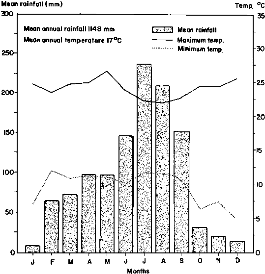
Source: Wagnew Ayalneh, ILCA, Addis Ababa (unpublished data).
Table 6. Distribution of Vertisols and their associations in Ethiopia (hectares).
|
No |
Zone |
Pellic Vertisols |
Chromic Vertisols |
Vertic Cambisols |
Other Vertic Soils |
Total |
|
1 |
Northern |
na |
512100 |
226100 |
450200 |
1188400 |
|
2 |
North-eastern |
174100 |
na |
na |
na |
174100 |
|
3 |
Eastern |
na |
1760000 |
831100 |
83600 |
2675500 |
|
4 |
Central |
1607200 |
na |
585400 |
576700 |
2769300 |
|
5 |
Southern |
1378300 |
525200 |
237200 |
21000 |
2161700 |
|
6 |
North-western |
433100 |
1579000 |
na |
na |
2012100 |
|
7 |
Western |
1761600 |
25000 |
na |
na |
1786500 |
|
Total |
|
5345300 |
4379600 |
1879800 |
1131500 |
12767600 |
na = nil or negligible area.
Source: Adapted from Berhanu Debele (1985).
Table 7. Grain yields of food crops on Vertisols under traditional management in the central Ethiopian highlands.
|
Crop |
Grain yields (kg/ha) |
|
Teff |
530 |
|
Barley |
860 |
|
Emmer wheat |
680 |
|
Durum wheat |
610 |
|
Horsebean |
750 |
|
Linseed |
300 |
|
Lentils |
500 |
|
Chickpea |
600 |
|
Field pea |
730 |
|
Noug (Guizotia abyssinica) |
290 |
|
Vetch (Vicia latyroides) |
690 |
Source: Berhanu Debele (1985).
Table 8. Potential arable areas (in thousand ha) of Vertisols in the different thermal and growing period zones.
|
Thermal zone |
Length of growing period (LGP) |
Total |
||||
|
L1 |
L2 |
L3 |
L4 |
L5 |
||
|
T1 |
230 |
170 |
630 |
690 |
40 |
1760 |
|
T2 |
704 |
1888 |
613 |
107 |
119 |
3431 |
|
T3 |
182 |
511 |
1279 |
1588 |
461 |
4021 |
|
T4 |
na |
77 |
602 |
1310 |
634 |
2623 |
|
T5 |
na |
36 |
15 |
47 |
3 |
101 |
|
Total |
116 |
2682 |
3139 |
3742 |
1257 |
11936 |
|
L1 = |
< 90 days | |
|
L2 = |
91-150 days | |
|
L3 = |
151-210 days | |
|
L4 = |
211-270 days | |
|
L5 = |
> 270 days | |
|
na = |
not available. | |
|
T1 = |
< 500 m |
altitude |
|
T2 = |
500-1300 m |
" |
|
T3 = |
1300-2000 m |
" |
|
T4 = |
2000-3000 m |
" |
|
T5 = |
> 3000 m |
" |
Source: Bull (1988).
![]()
![]()
![]()