Chapter 9. Status of soil pollution in Latin America and the Caribbean
Spatial distribution of soil pollution in Latin America and the Caribbean
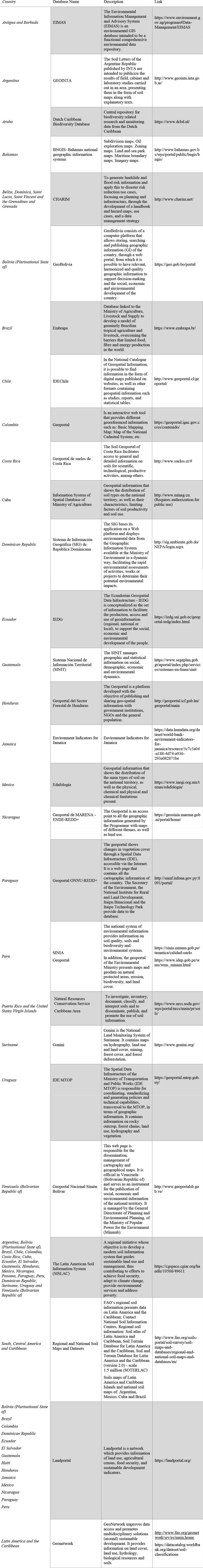
To analyse the regional extent of soil pollution, the availability of national soil information systems in the countries was checked, as well as national soil maps and spatial distribution maps of different contaminants. Most countries have databases and specific portals of georeferenced soil information; however, these are mainly used to show the distribution of soil types over territories, land use, production, natural resources, disaster risks and environmental indicators.
Some countries are developing soil databases and information systems, although few of them include specific information on soil pollution. Soil data for Puerto Rico and the United States Virgin Islands are of good quality. The Dominican Republic’s Geographic Information System (GIS) shows the environmental impacts and environmental assessment of different activities. The soil geoportal of Costa Rica has detailed information on soils. The Peruvian environmental information system SINIA provides data on soil quality, soil biodiversity and environmental systems in the country. The Latin American Soil Information System (SISLAC), which is a regional collection of South, Central America and Caribbean National Soil Maps and Datasets provides regional information on soils that can guide sustainable land use and management. The system was developed in cooperation with FAO and is available online (http://54.229.242.119/sislac/en).
Table 2 shows the existing databases in the region, along with a description of each of them and links to consult them. Information on the updating of these databases is not available in most of them and in some cases, especially in government databases, require credentials to access them.
Table 2. Databases of georeferenced soil information in Latin-America and the Caribbean countries.
In addition to this information, official reports are the main mechanism for identifying and monitoring soil pollution in the region. However, in many cases these reports are carried out on an ad hoc basis, under projects financed by FAO, Inter-American Development Bank (IDB), World Bank/GEF, ECLAC, Pan American Health Organization (PAHO), WHO and UNEP, among others. Few countries have specific soil monitoring programmes, most only undertaking one-off inventories, and it is common to find partial information from which to infer soil pollution. In many cases, information on soil pollution is scattered in reports from different institutions (e.g. agriculture, environmental, economic, and infrastructure). It is therefore necessary to link information from these different sources to understand the total extent of soil pollution.
Mexico has one of the best monitoring systems for polluted sites. It was developed between 2006 and 2011, and during this period, 333 potentially contaminated sites and 21 polluted sites were registered (Secretaría de Medio Ambiente y Recursos Naturales, 2018). Additionally, between 2008 and 2013, 627 sites polluted by environmental emergencies, such as industrial accidents and spillages, were identified (Figure 10). The main sources of soil pollution from accidents were transport, oil extraction and refining, and railways. The main contaminants associated with these environmental emergencies were hydrocarbons (gasoline, diesel and fuel oil), and other contaminants, such as acids and bases (SEMARNAT, 2012a).
Figure 10. Polluted sites in Mexico from 1995 to 2013.

Source: UN, 2020 modified with data from SEMARNAT, 2014.
9.3.1. Soil pollution in the Caribbean
The GEF regional project “Integrating Water, Land and Ecosystems Management in Caribbean Small Island Developing States” (IWEco)” has instituted a national sub-project in Antigua and Barbuda with additional support from the country’s Ministry of Health & Environment. The sub-project focused on land degradation and effective land management through the development of innovative financing methods (IWEco, 2016). The project concentrated on the reduction of wastewater effluents and the disposal of oily waste into the environment in response to the inappropriate location and insufficient number of wastewater disposal systems. The area affected by the oily waste landfill was approximately 14 ha of land near the Western coast of the island. The project was developed in response to the increase in domestic waste production from 20 500 tonnes in 2006 to 22 700 tonnes in 2009 (OPS, 2012b). Uncollected household waste was estimated at 295 tonnes/year (Diez et al., 2019) and each inhabitant was generating solid wastes at the rate of approximately 5.50 kg/day according to Hernández Berriel et al. (2016). As part of this project, adequate treatment facilities were installed to absorb additional leachate from national landfills, the wastewater treatment plant was expanded to treat additional wastewater, land degradation control measures were implemented and process indicators were improved to monitor improvements in land, water and wastewater management.
In the Bahamas, little information is available on soil pollution. Oil spills are frequent in the coast but also inland. Additionally, in 2019, the northern island suffered an environmental disaster when Hurricane Dorian (Figure 11) caused severe damage to oil storage facilities, resulting in a major oil leak (El Informador, 2019). An additional problem, as reported in the Status of the Environment report of Bahamas (UNEP, 2005), is the lack of proper facilities for hazardous waste, which could also be transported off-site by the hurricane.
Figure 11. Devastation left in the Bahamas after the Dorian Hurricane pass. ©Office of Rep. Debbie Wasserman Schultz (Public domain, via Wikimedia Commons).

On Curaçao, oil pollution surveillance is carried out due to the frequency of spills from a refinery, a situation that is also repeated on other Caribbean islands (Organización Panamericana de la Salud, 2012). High levels of trace elements (Fitz, 2016), together with potentially toxic material (asbestos, heavy metals, etc.) have been reported in an area of 52 ha around the refinery (Otromundoesposible, 2013).
Gilles and Alain (2005) identified a potential source of soil pollution when they detected chlordecone (a POP), metabolites of aldicarb and two triazines (ametryn and simazine) along the coastline of Martinique. The use of chlordecone had been banned in 1993. In Haina, located south of Santo Domingo (Dominican Republic), lead pollution was detected in the soil from a battery recycling plant, which operated for 20 years in the area. The results showed that the soil in the vicinity of the former battery plant and the zone located downhill is still polluted with high levels of lead compared to the legal limits established by several international administrations. Zinc was also found in the same area but the level of pollution was less severe (Ramírez Sánchez, 2017).
In 2013, Cuba established a National Hygiene and Health Commission in charge of the identification and managing of pollution issues in the island. The inventory carried out by the commission identified 14 426 hot spots including atmospheric emissions, direct emissions to water bodies, municipal waste and potentially polluting industries including mining (Figueredo Reinaldo, 2018).
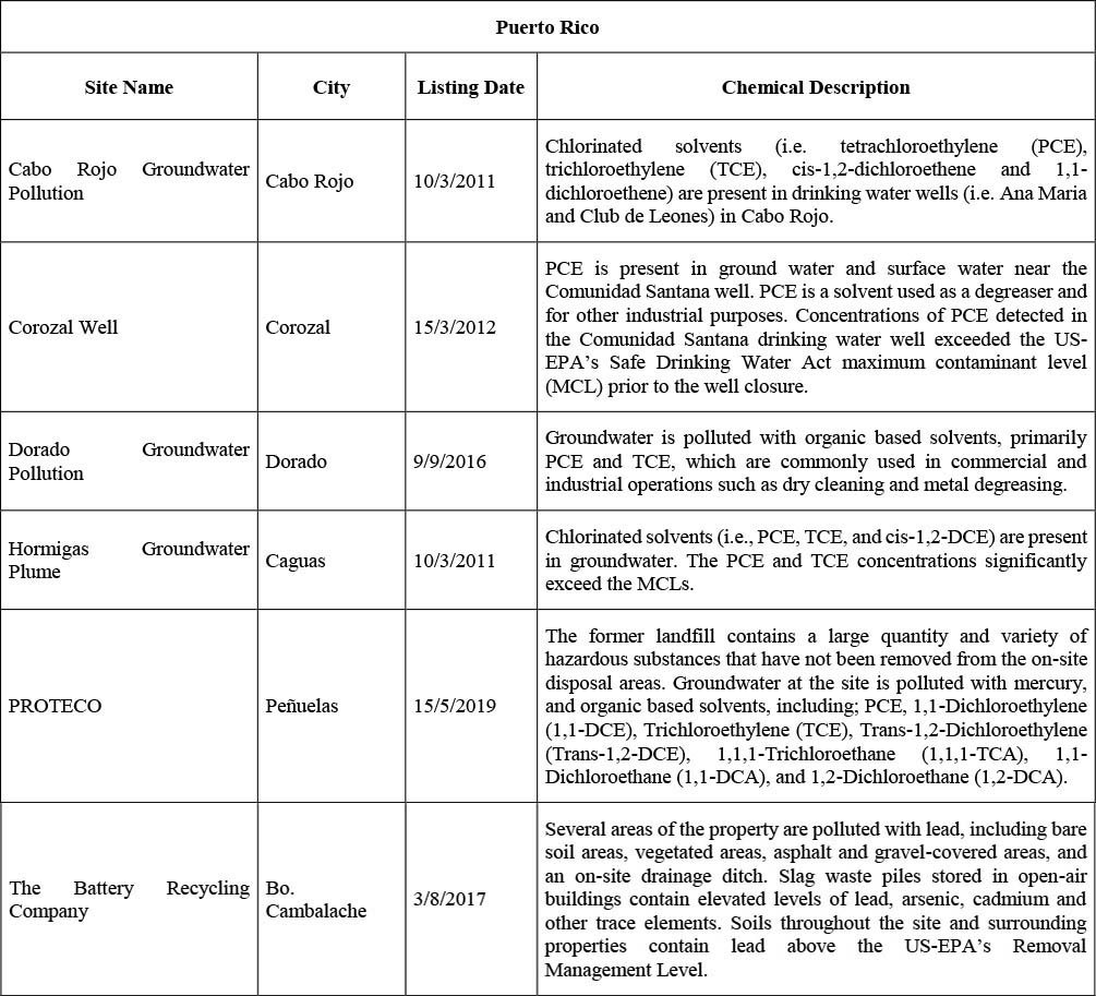
The most complete information of the Caribbean comes from Puerto Rico and the United States Virgin Islands, as they are covered by the United States Environmental Protection Agency’s Superfund programme. The programme addresses major polluted sites where chemicals or hazardous waste have been dumped, left out in the open, leaked or otherwise improperly managed. These sites include manufacturing facilities, processing plants, landfills and mining sites (EPA, 2018). The objectives of the Superfund programme are to: protect human health and the environment by cleaning up polluted sites; make responsible parties pay for remediation work; involve communities in the Superfund process; and return Superfund sites to productive use (EPA, 2018). Table 3 presents the Superfund sites in Puerto Rico listed as such since 2010, indicating the hazardous chemicals found there. Trace elements, chlorinated solvents, organic solvents and volatile organic compounds are the most common substances found at these sites.
Table 3. Superfund sites in Puerto Rico included since 2010.
9.3.2. Soil pollution in Central America
According to the Department of Environment Belize (2012), the country is vulnerable to pollution because industries are unable to properly manage their wastes because of the lack of environmentally sound waste management facilities. Despite some programmes to develop alternatives, there is still insufficient capacity to prevent pollution.
The agricultural sector is responsible for soil pollution issues in Belize, although the area affected is yet unknown. Belize’s sugar industry produces an average of 400 000 tonnes of solid waste known as bagasse. The by-product is highly valuable, as it can be used to generate electricity, which contributes to 15 percent of the energy production in the island (Gongora and Villafranco, 2018). However, the bagasse remains on site until its treatment, and can be affected by wind and water erosion, transporting the contaminants by runoff. Additionally, the wastewater generated in the industrial process contains variable loads of several contaminants, including nitrates and oils. Both runoff water and wastewater seeps into the soil and eventually enters the nearby New River (Chicas, 2008). The banana industry generates over 15 000 tonnes of solid waste per year and is highly dependent on pesticides. Soil pollution by pesticides and trace elements such as lead was observed in agricultural areas and in the vicinity of open dumps, also affecting marine ecosystems due to the transport of contaminants by runoff (Alegria, 2009).
In Costa Rica, according to MINAE-Ministerio de Ambiente y Energia (2017), in 2005, it was determined that 25 percent of its soils were affected by overexploitation and that by 2015, 10 percent of the national territory had erosion problems, with national water bodies being affected by sediment runoff. In 2004, Costa Rica was also affected by an oil spill in Barreal-Belén, affected by over 30 000 L of oil leachate from a petrol station that reached the aquifer. Since 2006, a special commission was established to remediate hydrocarbon-polluted sites through water extraction and soil measurements (Vargas-Fallas, 2009), however these remediation processes have shown to be very costly and effective only in the medium to long-term. Costa Rica counts with over 350 petrol stations that are potential polluting sources, so prevention measure must be taken (Vargas-Fallas, 2011).
In El Salvador, soil pollution by agrochemicals and toxic wastes is one of the major environmental problems (MARN, 2016a). More than 62 tonnes of pesticides and other toxic wastes were identified in the Inventory of Pesticides and Polluted Sites carried out by the Ministry of Environment and Natural Resources in 2012. One of the most heavily polluted sites is located in Cantón Sitio del Niño, where lead and cyanides were detected in the soil around a former lead acid automotive battery recycling and smelting plant, which operated until 2007. Lead levels over 400 mg/kg were detected in soil samples at a distance of 400 meters from the plant. At an agricultural chemical plant, almost 20 tonnes of highly toxic pesticides were found (toxaphene, ethyl parathion and methyl parathion) that are affecting the surrounding soils and water bodies, although the affected area was not yet defined. In the San Sebastián mine, acid drainage with a pH less than 3 and cyanide pollution was detected in the San Sebastián river, 500 metres from the mine exit, so it is estimated that the soils between the mine and the river are affected by this acid pollution (MARN, 2016a).
According to the National Implementation Plan of the Stockholm Convention in Guatemala, around 150 polluted or potentially polluted sites were identified containing over 60 000 kg of different contaminants: 4 sites with pesticides (15 000 kg of DDT), 48 polluted site with PCBs and 12 sited polluted with 2 000 kg of PFOS. Polychlorinated dibenzodioxins and furans were detected in waste disposal sites, mainly open-air dumps accounting for emissions of 18.311 g TEQ1/year (MARN, 2016b). In 2008, up to 288 polluted sites were identified, corresponding to illegal dumpsites, untreated wastewater discharges, and untreated sanitary discharges (MARN, 2017).
In Honduras, the implementation of the Stockholm Convention has determined 42 locations potentially polluted with POPs. In 2 sites, soil pollution by products containing POPs was confirmed: one in the landfill belonging to the most important banana companies in the north of the country, with approximately 3 500 kg of DDT residues mixed with fenitrothion, and the other in the warehouse of the Ministry of Health, with 1.6 tonnes of products polluted with POPs. In other twenty-three sites, non-POPs obsolete pesticides were found (SERNA-Secretaría de Recursos Naturales y Ambiente and CESCCO-Centro de Estudios y Control de Contaminantes, 2009).
In Nicaragua’s State of the Environment Report, sites polluted by mining, such as the mines of Bonanza, Rosita, and Siuna were reported to be affected by lead, cyanide, mercury and arsenic pollution. In addition, organochlorine contaminants such as toxaphene, DDT, DDD, DDE, endrin, and aldrin were found in cotton-growing areas (El Viejo, Chinandega, Chichigalpa, Leon, and Tisma) at concentrations above US EPA standards. Sites affected by about 6.7 tonnes of POPs pesticides were identified in 2009 pending of remedial and management actions (MARENA, 2010).
9.3.3. Soil pollution in South America
In Colombia, according to the Comptroller General of the Republic, 80 municipalities and 17 departments have pollution problems caused by mercury used in artisanal gold extraction. The risk affects the states of Amazonas, Antioquia, Bolívar, Caldas, Cauca and Chocó, where in 2010 approximately 350 000 kg of mercury were released into the environment (Martínez Sepúlveda, 2018). In addition, the country has an inventory of PCB stocks, which indicates that there are 19 000 tonnes of PCBs in the country (Ministerio de Ambiente Vivienda y Desarrollo Territorial, 2007a). A national inventory of POPs pesticides indicated that there are almost 2 400 m3 of soils polluted with POPs, located mainly in the departments of César, Bolívar, Tolima and Atlántico, and about 160 000 kg of DDT that are stored or buried with limited containment measures. Both are potential sources of soil pollution (Ministerio de Ambiente Vivienda y Desarrollo Territorial, 2007b). The consolidated inventory of PCDD/Fs indicated that about 18.40 g TEQ have been directly applied or leached from waste to soils during a five year period following the baseline year 2002 (Ministerio de Ambiente Vivienda y Desarrollo Territorial, 2007c).
In Argentina, more than 4 500 hydrocarbon spills were reported in 2011 (Rodríguez López and Burucua, 2015). In the Chubut area were 1 800 inactive and abandoned oil wells, where a high risk of hydrocarbons leaching exists. The Province of Santa Cruz counts with 13 000 inactive oil wells of which 8 000 are abandoned and in a poor maintenance state, that represents 100 000 ha of unproductive soils due to the levels of soil pollution. In addition, 97 environmental incidents related to the drainage of a 600 cubic meters pool of hydrocarbon waste need to be remediated in the Loma La Lata, which have caused high levels of soil pollution by hydrocarbons and trace elements in the area affecting local communities (Rodríguez López and Burucua, 2015).
Ecuador launched a project in 2014 to identify sites possibly polluted with PCBs. Environmental characterizations were performed in 16 utilities sites, including environmental characterization of soil, surface and groundwater; development of conceptual models for the assessment of pollution risks; development of remediation strategies; and excavation, removal, packaging, labelling and storage of affected soils (Ministerio del Ambiente de Ecuador, 2017). By 2017, approximately 2 500 polluted sites had been identified in the Ecuadorian Amazon. These sites include those polluted with oil of which 28 percent had already been remediated. Remediation of the remaining sites was awaiting the outcome of legal proceedings to determine liability for the cost (COMERCIO, 2017).
In the Plurinational State of Bolivia, several polluted sites were found in 2017, including two sites with mercury pollution in the Yungas area (Municipalities of Coroico, Teoponte, and Tipuani). In the cities of Frankeita, La Paz, Milluni, Oruro, and Santa Rita, soil analysis detected lead, cadmium, arsenic, and zinc at levels above those recommended by the environmental authorities (Condarco, 2017).
In 2009 the Chilean Ministry of the Environment enacted a policy for the management of sites that may contain contaminants. In 2013, a methodology to determine the presence of contaminants in soils was established and an inventory with 590 potentially polluted sites was developed, according to this methodology that need to be further analysed to confirm the potential risk (Figure 12). Priority was given to the regions of Arica and Parinacota, and Antofagasta because of the severity of the pollution and the greater number of people threatened by adverse health impacts (Rojas et al., 2015).
Figure 12. Potentially polluted sites by activity in Chile in 2016.

In 2016, the Institute of Technological Research of the Secretariat of Economic Development, Science, Technology and Innovation of the State of São Paulo, Brazil, published an inventory of polluted areas. The inventory gathered information from the State’s environmental agencies and environmental consulting firms. The inventory found that in 2017, the most common polluting activities in the city of São Paulo were vehicle service stations. The inventory identified a total of 2 148 polluted sites, of which 1 579 were polluted areas under service stations (Lino and Aquino, 2019). Drahansky et al. (2016) indicated that in 2012 São Paulo had 4 572 polluted areas with concentrations of trace elements, such as copper, mercury, and zinc, above the soil quality limits recommended by the Brazilian Procedure for the Protection of Soil and Groundwater Quality (Cesar et al., 2011; CETESB, 2017). Larger POPs contaminated sites have also been documented in Brazil (Torres et al., 2013a, 2013b). Feedstuff manufactured in Brazil from citrus pellets became contaminated with PCDD, through the use of contaminated lime in the manufacturing process. The contaminated lime had been recovered from a landfill site of the organochlorine industry. The feedstuff was exported to Europe (Torres et al., 2013b). Furthermore, in Brazil, large amounts of the pesticide sulfluramide, a precursor of perfluorooctanesulfonate (PFOS), are used against leaf-cutting ants, causing soil, groundwater and sediments pollution and posing a risk to cattle (Guida et al., 2019; Nascimento et al., 2018). Actions are being taken to prevent the illegal use and commercialisation of pesticides in Brazil (Figure 13).
Figure 13. The Brazilian government performs regular controls to prevent the illegal use and commercialisation of highly hazardous pesticides. © Vinícius Mendonça/Ibama (via Wikimedia Commons, CC BY 2.0).

Paraguay and Brazil developed a bilateral technical cooperation agreement on the evaluation of polluted sites. In Paraguay, 75 percent of polluted sites are located near urban settlements in the central area where approximately one-third of the country’s population lives. Pesticide companies, hospital waste incinerators, municipal landfills, tanneries, PCB waste deposits, mining companies and others were considered the main polluting activities (PAHO, 2014).
In Suriname, although all stockpiles of obsolete pesticides were eliminated by 2018, soils and groundwater at those storage locations may well be polluted. A range of sites potentially contaminated with PCBs, PBDEs and PFOS were discovered during the development of the updated Stockholm Convention National Implementation Plan (Weber, 2019). It was concluded that some of the sites are likely to represent a continued risk of exposure to humans and require urgent assessment. Similar assessments have been conducted in many other Caribbean countries and are compiled in the updated Stockholm Convention NIPs. Furthermore, action plans to address these sites have been developed in their respective National Implementation Plans.
- 1 TEQ refers to toxic equivalency. TEQs are a weighted quantity measure based on the toxicity of each member of the dioxin and dioxin-like compounds category relative to the most toxic members of the category.