

Effective implementation of land degradation responses depends on both the condition of the land and the type of farm structure. In practice, this means distinguishing between areas where land remains under active use but requires improved management, and areas where degradation is so severe that a complete change in land use is necessary (Table 3). In both cases, policies must be realistic for farmers to adopt and feasible to implement at scale, striking a balance between short-term profitability and long-term sustainability to ensure uptake and impact.64
Where land remains in use but shows signs of degradation, the focus is on improving land management practices. These may include soil and water conservation, agroforestry, and reduced tillage. Regulatory measures can promote adoption, but their effectiveness depends on farmers’ capacity to comply. Incentive-based schemes can help offset opportunity costs and provide technical support, particularly for smallholders, and their outcomes can be further enhanced through cross-compliance. However, efforts to promote sustainable land management can be costly to implement and monitor, especially in areas with a large number of small-scale farms.48, 69, 70
The burden of implementation varies by farm size. Smallholders often experience the added burden of lacking the livelihood security or financial margins needed to adopt sustainable land-use practices such as fallowing to reduce nutrient mining. Larger farms, by contrast, benefit from economies of scale and are often better positioned to meet compliance or reporting requirements.71, 72 Policies and institutions may be biased towards larger farms, reinforcing disparities.73, 74 For an example of how regulatory burdens can fall unevenly according to farm size, see Box 21, which documents the potential impacts of EU Deforestation Regulation going beyond national and EU jurisdictions. To ensure equitable outcomes, enabling measures such as secure land tenure, access to extension services and support for farmer cooperatives are essential.
Box 21Differential impacts of deforestation regulations by farm size
Agriculture is the leading driver of tropical deforestation, a trend that continues to grow, posing severe threats to the climate, biodiversity and ecosystems.75–78 Forest loss also endangers the food security of the 1.6 billion people worldwide who live within 5 km of forests.79 A major obstacle to reducing deforestation lies in understanding the diverse farming activities within forested landscapes. Existing agrifood system models have attempted to quantify the extent and sources of deforestation linked to crop and livestock products, yet they fall short of attributing forest loss to individual farms. This gap hinders the development of targeted interventions.80
A new study led by researchers at Leiden University’s Institute of Environmental Sciences (CML) addresses this issue by combining spatially modelled field size data with data on forest cover and crop yields.81–83 The study assesses the contribution of small-, medium- and large-scale farmers to agricultural production in forest-dominated areas. It finds that roughly one-third of farms intersect with forested regions, and that smallholder farms are the most prevalent farm type in these landscapes. This finding reflects the recent assertion that smallholders (albeit defined differently) are responsible for most global deforestation – although in South America and Asia, there are areas where large-scale farming is the main driver of deforestation.84
These insights are crucial for shaping effective deforestation policies, including the European Union Deforestation Regulation (EUDR). The EUDR will require cocoa, coffee, palm oil, natural rubber, cattle (beef), soybean and timber products and their derivatives to be free from deforestation.85 To comply, farmers must submit geolocation data; non-compliance means they risk exclusion from international markets. The CML study applies the EU Joint Research Centre’s forest map to identify high-risk farms, countries and commodities within this regulatory framework.81
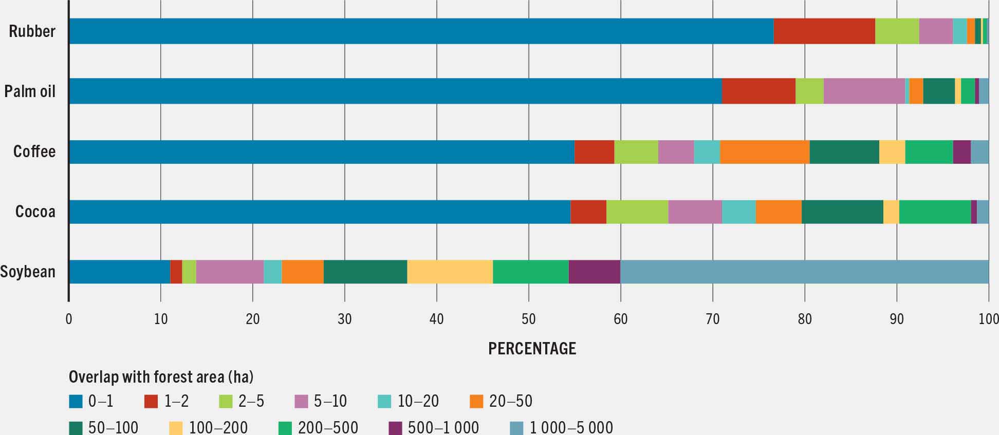
Smallholder farmers account for the largest share of forest-dominated land used to produce several forest-risk commodities (see figure), including rubber (88 percent), palm oil (79 percent), coffee (59 percent) and cocoa (58 percent). In contrast, large-scale farmers dominate soybean cultivation in forested areas. These findings highlight the importance of understanding the types of farms that will be affected by policies. If smallholders are disproportionately affected, additional measures may be needed to address the limited technical and financial capacities of small-scale farmers, including support for data collection, certification and compliance. These are critical to ensure that forest conservation initiatives do not come at the cost of smallholder livelihoods.
FIGURE PRODUCTION OF EUROPEAN UNION DEFORESTATION REGULATION-LISTED CROPS OVERLAPPING WITH FOREST AREAS, SHOWN BY CONTRIBUTION BY FARM SIZE
In severely degraded or abandoned lands, the objective is to reverse degradation through intensive restoration efforts. These areas require the most complex and resource-intensive interventions. Regulatory mandates may compel rehabilitation, while incentive-based programmes support major land-use changes such as afforestation and rewetting. Cross-compliance policies often involve coordinated legal, financial and technical tools within a project spanning multiple years and different stakeholders. Monitoring can be site-specific and long-term, but earth observation techniques are increasingly supporting governments in monitoring and enforcing LUCC regulations, particularly in areas where large-scale changes are expected. For example, in Inner Mongolia, remote sensing supported the monitoring of grazing reduction policies where payment schemes led to measurable improvements in grassland quality.86, 87
Restoration can require substantial public financing, often through donors or private sector cofinancing. The need for landscape-level restoration may even go beyond national jurisdictions; this is the case of the Green Wall for the Sahara Initiative – a pan-African effort across 22 countries, also known as the Great Green Wall – which aims to restore 100 Mha of land by combining national policy alignment with donor coordination and community engagement (Box 22). The effectiveness of these interventions depends on their integration with national strategies, long-term financing mechanisms, and the ability to sustain outcomes beyond the project cycle.
Box 22The Great Green Wall: restoring lands and livelihoods in the Sahara and the Sahel
Starting in the 1970s, vast swathes of fertile land in the Sahel, a region that spans the southern edge of the Sahara, started to become severely degraded.88 Decades of unsustainable land use, compounded by climate change and population pressures, made the area dry and barren, contributing to food insecurity, poverty and displacement across the broader Sahara and Sahel regions.
In response, the African Union launched the Great Green Wall (GGW) initiative in 2007 – a pan-African effort across 22 countries to restore 100 million hectares of degraded land, sequester 250 million tonnes of carbon and create 10 million green jobs by 2030. Around USD 19 billion has been pledged to date by partners including the African Development Bank, the World Bank, the European Union and the Green Climate Fund.89
Implementation varies by country, but is typically delivered through structured programmes that combine technical interventions with policy support, financing mechanisms, and monitoring systems. Coordination is led by the Pan-African Agency of the Great Green Wall, with technical backing from the United Nations Convention to Combat Desertification. To accelerate progress, the Great Green Wall Accelerator was launched in 2021 to enhance donor coordination, mobilize funding, and align international support with national restoration strategies.90
Action Against Desertification – a land restoration initiative within the GGW framework implemented in northern Nigeria from 2016 to 2020 – operated in areas where forest cover had experienced a 50 percent decline between 2007 and 2015, with most of the land converted to cropland.91 Focused on Bauchi, Jigawa and Sokoto states, the programme applied a livelihood-centred approach linking restoration with improved agricultural productivity, commercialization of non-timber forest products (NTFPs) and the provision of ecosystem services. A socioeconomic evaluation found that restoration activities did not adversely affect food security among participating households. On the contrary, moderate food insecurity declined, with households reporting fewer skipped meals and food shortages. These gains were associated with shifts in livelihood strategies – including reduced reliance on crop sales and increased engagement in the sale of livestock by-products and high-value NTFPs – highlighting the potential of integrated restoration efforts to deliver both environmental and socioeconomic benefits.
Integrated land use planning (ILUP) can help align these different types of interventions with both land condition and farm structure. By combining spatial data, stakeholder consultations and cross-sector coordination, ILUP supports the identification of appropriate policy tools and their adaptation to local realities. Box 23 illustrates how countries like Ecuador and Morocco are using participatory, data-driven planning tools to guide sustainable land management decisions. These experiences highlight the importance of embedding technical analysis within inclusive planning processes to ensure that land restoration efforts are both targeted and equitable.
Box 23Implementing sustainable land management: lessons from Morocco and Ecuador
Integrated land use planning through participatory and data-driven solutions is increasingly becoming integral to country policymaking within the framework of land degradation neutrality and the broader Sustainable Development Goals.
In Ecuador, a tool was developed to support the country’s Land Degradation Neutrality goals.92 Built on a user-friendly digital platform, the tool integrates biophysical and socioeconomic data including survey and geospatial data, as well as documented sustainable land management (SLM) practices. Developed with input from national and international experts, public officials and stakeholders, the tool helps decision-makers to prioritize interventions. This inclusive approach strengthens cross-sector collaboration and will support Ecuador’s reporting progress to the United Nations Convention to Combat Desertification. The tool is open source and can be adapted for use in other countries and regions.
A similar approach was applied in Morocco: in 2015, a detailed land degradation assessment in the Souss-Massa region found that approximately 19 percent of land was degraded. The assessment helped map degradation hotspots and existing SLM areas, and was supported by a participatory planning process involving local communities and institutions.93 This process led to a territorial planning pact and a three-year action plan to integrate SLM into local development priorities. The initiative showed how combining technical analysis with community engagement can lead to more effective, inclusive land use planning.
To scale such efforts globally, FAO promotes integrated land use planning, a systematic approach to evaluating and selecting the most appropriate land uses to balance environmental, economic and social goals.94 FAO is currently updating the 1993 Guidelines on Land Use Planning to emphasize recent trends, including the optimization of resources, stakeholder consultation and multidisciplinary technical support.95


